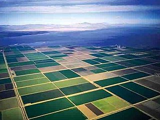
Located on the northeastern side of the Salton Sea, the Salton Sea State Recreation Area offers hunting, fishing, swimming, and camping to visitors.

Guthrie is an unincorporated community in Marshall Township, Lawrence County, Indiana.

Tarry Park is an unincorporated community in Marion Township, Lawrence County, Indiana.

Amos is an unincorporated community in Imperial County, California. It is located on the Southern Pacific Railroad 15 miles (24 km) east of Calipatria, at an elevation of 262 feet.

Bertram is an unincorporated community in Imperial County, California. It is located on the Southern Pacific Railroad 24 miles (39 km) northwest of Calipatria, at an elevation of 187 feet below sea level.

Butlers is a former settlement in Imperial County, California. It was located on the Southern Pacific Railroad 10.5 miles (17 km) southeast of Calipatria, at an elevation of 102 feet below sea level. Butlers still appeared on maps as of 1947.

Fondo is an unincorporated community in Imperial County, California. It is located on the Southern Pacific Railroad 6.5 miles (10 km) west of Calipatria, at an elevation of 203 feet below sea level.

Frink is an unincorporated community in Imperial County, California. It is located on the Southern Pacific Railroad 18 miles (29 km) north-northwest of Calipatria, at an elevation of 171 feet below sea level.

Hovley is an unincorporated community in Imperial County, California. It is located on the Southern Pacific Railroad 8.5 miles (14 km) south of Calipatria, at an elevation of 138 feet below sea level.

Iris is an unincorporated community in Imperial County, California. It is located on the Southern Pacific Railroad 8 miles (13 km) northeast of Calipatria, at an elevation of 82 feet.

Kane Spring is an unincorporated community in Imperial County, California. It is located 1.9 km (1.2 mi) south-southwest of San Felipe Wash and 8 km (5 mi) west of the southwestern extension of the Salton Sea, at an elevation of 141 feet below sea level.

Mundo is an unincorporated community in Imperial County, California. It is located on the Southern Pacific Railroad 7.5 miles (12 km) southeast of Frink, at an elevation of 190 feet below sea level.

Munyon is an unincorporated community in Imperial County, California. It is located on a former branch of the Southern Pacific Railroad 8 miles (13 km) southeast of Calipatria, at an elevation of 108 feet below sea level.

Pope is an unincorporated community in Imperial County, California. It is located on the Southern Pacific Railroad 4.5 miles (7.2 km) west of Frink, at an elevation of 197 feet below sea level.

Squeaky Springs is a former settlement in Imperial County, California.

Tortuga is an unincorporated community in Imperial County, California. It is located on the Southern Pacific Railroad 10.5 miles (17 km) east-northeast of Calipatria, at an elevation of 187 feet. The name Tortuga means "turtle" in Spanish.

Verdant is an unincorporated community in Imperial County, California. It is located on the Southern Pacific Railroad 2.5 miles (4 km) west-southwest of Calipatria, at an elevation of 197 feet below sea level.

Wister is an unincorporated community in Imperial County, California. It is located on the Southern Pacific Railroad 4.25 miles (6.8 km) southeast of Frink, at an elevation of 197 feet below sea level.

Washington Center is an unincorporated community in Washington Township, Whitley County, in the U.S. state of Indiana.
Rock is an unincorporated community in Vernon County, in the U.S. state of Missouri.


