You can help expand this article with text translated from the corresponding article in Welsh. (January 2023)Click [show] for important translation instructions.
|
Bethania is a hamlet in Ceredigion, mid Wales.
You can help expand this article with text translated from the corresponding article in Welsh. (January 2023)Click [show] for important translation instructions.
|
Bethania is a hamlet in Ceredigion, mid Wales.
The centre of this dispersed community in the rural heart of the county is at the junction of the B4577 and B4576 roads. [1]
The bottling plant of the Tŷ Nant bottled water company is nearby.

The Arctic Archipelago, also known as the Canadian Arctic Archipelago, is an archipelago lying to the north of the Canadian continental mainland, excluding Greenland and Iceland.
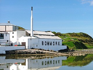
Bowmore distillery is a Islay single malt Scotch whisky distillery located on the Isle of Islay, an island of the Inner Hebrides.

Tresaith is a coastal village in Ceredigion, Wales, between Aberporth and Llangranog. It is linked to the former by a two-mile section of the Ceredigion Coast Path, part of the Wales Coast Path. Tresaith is within the Ceredigion Heritage Coast which offers extensive walking and views. There is an abundance of wildlife and flora. Many kinds of seabirds can be spotted and regular sightings of grey seals and dolphins are made. The village derives its name from the Saith, a small river/stream that runs down the valley towards the east side of the village before flowing into the sea via a waterfall.

Colwall railway station is a railway station on the Cotswold Line serving the village of Colwall in Herefordshire, England. The station has one platform with seating. There is no ticket office; a passenger-operated Permit to Travel machine is installed, and there has been a ticket machine since 2015.

The Gladstone Pottery Museum is a working museum of a medium-sized coal-fired pottery, typical of those once common in the North Staffordshire area of England from the time of the Industrial Revolution in the 18th century to the mid 20th century. It is a grade II* listed building.

Aluminium monochloride, or chloridoaluminium is the metal halide with the formula AlCl. Aluminium monochloride as a molecule is thermodynamically stable at high temperature and low pressure only. This compound is produced as a step in the Alcan process to smelt aluminium from an aluminium-rich alloy. When the alloy is placed in a reactor that is heated to 1,300 °C and mixed with aluminium trichloride, a gas of aluminium monochloride is produced.
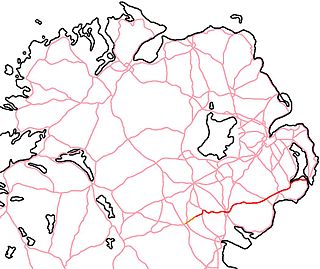
The A25 is the name given to the sections of the main route connecting Strangford with Castleblayney that lie in Northern Ireland. It is a road of regional importance, serving much of south Armagh and south Down. The road commences in the village of Strangford, on the shores of Strangford Lough, from which the Portaferry - Strangford Ferry service transports vehicles to Portaferry on the Ards peninsula. The entirety of the route is 61.2 miles, of which 54.5 miles are located north of the border, forming the A25 - the remaining 6.7 miles form the R182 in the Republic of Ireland.
The Little River is a short river in Madawaska, Maine, about 4 miles (6 km) from the Canada–United States border. The river flows west 5.1 miles (8.2 km) from its source to Long Lake. The lake drains — via Mud Lake, Cross Lake, Square Lake, and Eagle Lake — into the Fish River, a tributary of the Saint John River.

The Little River is a short, mostly-tidal river in Perry, Maine. From Boyden Stream Reservoir it runs about 2 miles (3 km) east to Passamaquoddy Bay.

Malvern Water is a brand of bottled drinking water obtained from a spring in the range of Malvern Hills that marks the border between the counties of Herefordshire and Worcestershire in England. The water is a natural spring water from the hills that consist of very hard granite rock. Fissures in the rock retain rain water, which slowly permeates through, escaping at the springs. The springs release an average of about 60 litres a minute. The flow rate depends on rainfall and can vary from as little as 36 litres per minute to over 350 litres per minute.
Cox Hill is a hamlet in the parish of Chacewater, Cornwall, England.
Strathclyde distillery is a grain spirit distillery producing PBS that will make grain whisky after maturation, located in the Gorbals district of Glasgow, Scotland.

KM-233 is a synthetic cannabinoid drug which is a structural analog of Δ8-tetrahydrocannabinol (THC), the less active but more stable isomer of the active component of Cannabis. KM-233 differs from Δ8-THC by the pentyl side chain being replaced by a 1,1-dimethylbenzyl group. It has high binding affinity in vitro for both the CB1 and CB2 receptors, with a CB2 affinity of 0.91 nM and 13-fold selectivity over the CB1 receptor. In animal studies, it has been found to be a potential treatment for glioma, a form of brain tumor. Many related analogues are known where the 1,1-dimethylbenzyl group is substituted or replaced by other groups, with a fairly well established structure-activity relationship.

JWH-116 is a synthetic cannabinoid receptor ligand from the naphthoylindole family. It is the indole 2-ethyl derivative of related compound JWH-018. The binding affinity of JWH-116 for the CB1 receptor is reported as Ki = 52 ± 5 nM.
Dingle Distillery is an Irish whiskey distillery established in 2012 and billing itself as an 'artisan' distillery. The distillery is located in a converted sawmill in Milltown on the outskirts of Dingle, in a Gaeltacht in the southwest of Ireland. The first whiskeys distilled and matured at the distillery were released in late 2016. In addition to whiskey, the distillery also produces and markets Dingle vodka and Dingle Gin.
Cucunatí is a corregimiento in Chepigana District, Darién Province, Panama with a population of 1,346 as of 2010. It was created by Law 58 of July 29, 1998, owing to the Declaration of Unconstitutionality of Law 1 of 1982. Its population as of 2000 was 1,105.
German submarine U-2509 was a Type XXI U-boat of Nazi Germany's Kriegsmarine, built for service in World War II. She was ordered on 6 November 1943, and was laid down on 17 June 1944 at the Blohm & Voss yard at Hamburg, as yard number 2509. She was launched on 27 August 1944, and commissioned under the command of Kapitänleutnant Rudolf Schendel on 21 September 1944.
Top-y-Fron Hall is a country house in the community of Connah's Quay, Wales. In 1977 it became a Grade II* listed building.

Naryn Castle or Narenj Castle is a castle in the city of Nain, Iran, and is one of the attractions of Nain County. This castle was built by the Parthian Empire.

The Tralee–Fenit Greenway is a greenway and rail trail in Ireland, which is due to form part of EuroVelo EV1 and the Great Southern Trail. The 14km route was planned to be completed by 2021, but delayed due to the COVID-19 pandemic, with a rescheduled opening of summer 2022. The first phase of the greenway, comprising 6.5km of the route, was opened in June 2022, this was extended to 11.2km in October 2022.
52°15′03″N4°05′23″W / 52.2509°N 4.0896°W
| | This Ceredigion location article is a stub. You can help Wikipedia by expanding it. |
