Nakodar is a town and a municipal council in Jalandhar district in the Indian state of Punjab.

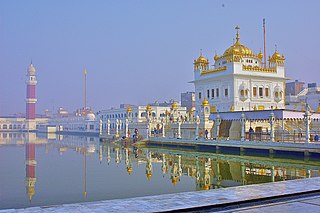
Tarn Taran Sahib is a city in the Majha region of the state of Punjab, in northern India. It is the district headquarters and hosts the municipal council of Tarn Taran district. Gurdwara Sri Tarn Taran Sahib, a prominent Sikh shrine, is located in the central part of the city.

Gurdaspur is a city in the Indian state of Punjab, between the rivers Beas and Ravi. It houses the administrative headquarters of Gurdaspur District and is in the geographical centre of the district, which shares a border with Pakistan.
Khem Karan is a town and a nagar panchayat in Tarn Taran district of Patti tehsil of the Majha region of the Indian state of Punjab.
Jobat is a city and a nagar parishad municipality in Alirajpur district in the Indian state of Madhya Pradesh.
Bhogpur is a town and a Nagar Panchayat in Jalandhar district in the state of Punjab, India. Bhogpur has a Dana Mandi and have subsequent villages under it. iI also acts as a route from Jalandhar to Tanda and is known for its famous sweet shops, and tailor shops. Sikhism is the major religion followed by Hinduism.
Daulatpur is a Town in Pathankot district in the state of Punjab, India.
Gagret is a nagar panchayat in Tehsil Ghanari of Una district in the state of Himachal Pradesh, India. It is situated in plains of Una.
Pratitnagar is a census town in Dehradun district in the Indian state of Uttarakhand.

Tarn Taran district is one of the districts in the Majha region of Punjab, India. The main cities are Tarn Taran Sahib, Bhikhiwind, Khadur Sahib and Patti. The City of Tarn Taran Sahib is a holy place for Sikhs.
Santoshpur is a census town in Uluberia II CD Block of Uluberia subdivision in Howrah district in the Indian state of West Bengal. It is a part of Kolkata Urban Agglomeration.
Patti is an old city, near Tarn Taran Sahib city and a municipal council of the Tarn Taran district in the Majha region of Indian state of Punjab, located 47 Kilometres from Amritsar. Patti city is situated close to the Pakistani border. It is connected through a rail network starting from Amritsar station to Khem Karan station, with Khem Karan being its last station of India.
Dhariwal is a fifth largest town and a municipal council in Gurdaspur district in the state of Punjab, India. Dhariwal was most famous for its woolen mill. This town is situated on the banks of river Upper Bari Duba and is 13 km away from Gurdaspur on the Gurdaspur-Batala highway. Dhariwal,like rest of north-western India, features a humid subtropical climate. Average yearly precipitation is about 925mm, 70% of it receives during monsoon season (June-September). Winter is also wet. June is the hottest while January is coldest month. In winter, dense fog persists for three to five days. As a result, day temperature drops to single digits. During May and June, dust storms followed by intense spells for short intervals are not uncommon. Monsoon arrives in the end of June and withdrawal starts around the third week of September. The town is prone to heatwaves during summer and chills during winter.
Kangan is a town located near Ganderbal, in the Ganderbal district of Jammu and Kashmir, India. It is one of the tehsils in District Ganderbal. It is situated across the Nallah Sindh and spread over a 50-km-long gorge valley, with population of 120,934 and literacy rate of 52.8% and sex ratio 868 per thousand males. Widely regarded for its beauty, it is surrounded by various picnic spots like Sonamarg and Naranag.
Fatehabad is a small town in the Tarn Taran district of Punjab State. in India, located about 20 km from Tarn Taran Sahib
Simalwara is a census town in Dungarpur district in the Indian state of Rajasthan. It is the administrative headquarters for Simalwara Tehsil.
Pattan, is a sub-district town and a municipal community in Baramulla district within the Indian Union Territory of Jammu and Kashmir.
Chung is a historical village in (Bhikhiwind), just 33 km from Tarn Taran Sahib in Patti tehsil of Tarn Taran district in the Indian state of Punjab. Before 1947, it was part of Kasur tehsil of Lahore district. Rice and wheat are the most cultivated crops.
Khadur Sahib is a town and a nagar panchayat in Tarn Taran district of Khadur Sahib tehsil of the Majha region of Indian state of Punjab. Khadur Sahib is a historical place in view of eight out of ten sikh gurus having visited this place. The postal index number of Khadur Sahib is 143117.
Chohla Sahib is a town and a nagar panchayat in Tarn Taran district of the Majha region of Indian state of Punjab. This town is located in Chohla Sahib development block. Chohla Sahib is a historical place in view of two sikh gurus having visited this place. The postal index number of Chohla Sahib is 143408.


