
Lynn Lake is a town in the northwest region of Manitoba, Canada, approximately 1,071 km (665 mi) from Winnipeg. The town is the fourth-largest town in Manitoba in terms of land area. It is centred on the original urban community of Lynn Lake, located at 56°51′06″N101°02′48″W. The town was named after Lynn Smith, chief engineer of Sherritt Gordon Mines Ltd. There are many outfitters in the Lynn Lake area. They offer services for most wilderness experiences, including sport fishing and bear and moose hunting.

Arthur-Virden is a provincial electoral division in the Canadian province of Manitoba. It was created by redistribution in 1989, combining the former constituencies of Arthur and Virden.
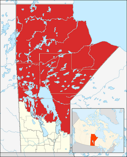
Northern Manitoba is the most northerly region of the Canadian province of Manitoba, added to the province during the last major expansion of its boundaries in 1912. Forestry, mining and hydro-electric development are significant economic drivers with long-term consequences to the environment in the region.
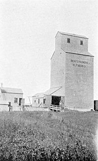
Benito is an unincorporated rural community in the Municipality of Swan Valley West within the Canadian province of Manitoba that held village status prior to January 1, 2015. The community is situated in the Swan River Valley, 37 kilometres southwest of Swan River, 475 kilometres northwest of Winnipeg, and 2 kilometres east of the Saskatchewan border. To the south is Duck Mountain Provincial Park and Forest, to the north is Thunder Hill and further north of Swan River is Porcupine Mountain Provincial Park. Benito is served by PTH 83.
Erickson is an unincorporated urban community in the Municipality of Clanwilliam – Erickson within the Canadian province of Manitoba that held town status prior to 1 January 2015. It is located on Highway 10 on 32-17-18W in south central Manitoba. The main industry of Erickson is agriculture. Its population is 487.
Vicksburg is a ghost town in Bay County, Florida, United States, located near the intersection of State Road 77 and County Road 388.

The Sam Waller Museum is a museum dedicated to preserving the history and artifacts of this region of northern Manitoba. The collections include First Nations, fur trading, mining, transportation. The museum is in the old courthouse, located in downtown The Pas, Manitoba.
The Rural Municipality of Edward is a former rural municipality (RM) in the Canadian province of Manitoba. It was originally incorporated as a rural municipality on December 1, 1905. It ceased on January 1, 2015 as a result of its provincially mandated amalgamation with the RM of Albert and the RM of Arthur to form the Municipality of Two Borders.
The Rural Municipality of Shellmouth-Boulton is a former rural municipality (RM) in the Canadian province of Manitoba. It was originally incorporated as a rural municipality on January 1, 1999. It ceased on January 1, 2015 as a result of its provincially mandated amalgamation with the RM of Silver Creek to form the Rural Municipality of Riding Mountain West.

Thạch Hóa is a commune (xã) and village in Tuyên Hóa District, Quảng Bình Province, in Vietnam.

Welwyn is a community in southeastern Saskatchewan, near the Manitoba border. The community was named for Welwyn, in Hertfordshire, England at the suggestion of James Wake, who homesteaded just across the Manitoba border.
Vandenberg Air Force Base Launch Facility 04 (LC-04) is a former United States Air Force (USAF) Intercontinental ballistic missile (ICBM) launch facility on Vandenberg Air Force Base, California, USA. It is a launch site for the land-based LGM-30 Minuteman missile series.
Kouaku is an island of the Gambier Islands of French Polynesia.
Lime Creek Township is a township in Washington County, Iowa, USA.
The Gordon Lathlin Memorial Centre is an indoor ice hockey arena located on the Opaskwayak Cree Nation reserve near The Pas, Manitoba, Canada. The 1,100-seat arena was built in 1985, and since 1996 it has been home to the OCN Blizzard, who play in the Manitoba Junior Hockey League. During a four-month off-season for hockey each year, the centre is used for social gatherings, concerts, weddings, and "Indian Days".
Prairie Centre Township is a township in Walsh County, North Dakota.
Rushford Township is a township in Walsh County, North Dakota.
Diggins Township is a township in Webster County, in the U.S. state of Missouri.

The Iglesia de las Santas Justa y Rufina is one of the so-called Mozarabic parish churches of Toledo, whose existence has been documented since 1156. However, certain material remains reveal the existence in this place of an Islamic construction, which would undoubtedly have to be identified with a mosque. Until very recently, the only testimony of the existence of an Islamic construction consisted of a fragment of arch that, on a Visigothic pilaster, was embedded in the northwest facade of the temple. The reuse of a piece from previous period, combined with the characteristics of the cutting of the arch, allow them to think of an Islamic work dating around 10th century.


