Bijat

Last updated
Bijat
Borneo Locator Topography.png
Red pog.svg
Bijat
Coordinates: 1°19′00″N111°24′00″E / 1.31667°N 111.4°E / 1.31667; 111.4 Coordinates: 1°19′00″N111°24′00″E / 1.31667°N 111.4°E / 1.31667; 111.4
Country Flag of Malaysia.svg  Malaysia
State Flag of Sarawak.svg  Sarawak
Elevation
51 m (167 ft)

Bijat is a settlement in Sarawak, Malaysia. [1] It lies approximately 122.3 kilometres (76.0 mi) east-south-east of the state capital Kuching. Neighbouring settlements include:

Sarawak State of Malaysia

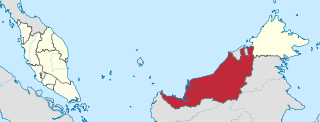
Sarawak is a state of Malaysia. Being the largest among 13 other states with the size almost equal to West Malaysia, Sarawak is located in northwest Borneo Island, and is bordered by the Malaysian state of Sabah to the northeast, Kalimantan to the south, and Brunei in the north. The capital city, Kuching, is the largest city in Sarawak, the economic centre of the state, and the seat of the Sarawak state government. Other cities and towns in Sarawak include Miri, Sibu, and Bintulu. As of the 2015 census, the population of Sarawak was 2,636,000. Sarawak has an equatorial climate with tropical rainforests and abundant animal and plant species. It has several prominent cave systems at Gunung Mulu National Park. Rajang River is the longest river in Malaysia; Bakun Dam, one of the largest dams in Southeast Asia, is located on one of its tributaries, the Balui River. Mount Murud is the highest point in Sarawak.

Malaysia Federal constitutional monarchy in Southeast Asia

Malaysia is a country in Southeast Asia. The federal constitutional monarchy consists of 13 states and three federal territories, separated by the South China Sea into two similarly sized regions, Peninsular Malaysia and East Malaysia. Peninsular Malaysia shares a land and maritime border with Thailand in the north and maritime borders with Singapore in the south, Vietnam in the northeast, and Indonesia in the west. East Malaysia shares land and maritime borders with Brunei and Indonesia and a maritime border with the Philippines and Vietnam. Kuala Lumpur is the national capital and largest city while Putrajaya is the seat of federal government. With a population of over 30 million, Malaysia is the world's 44th most populous country. The southernmost point of continental Eurasia, Tanjung Piai, is in Malaysia. In the tropics, Malaysia is one of 17 megadiverse countries, with large numbers of endemic species.

Kuching City and State Capital in Sarawak, Malaysia

Kuching, officially the City of Kuching, is the capital and the most populous city in the state of Sarawak in Malaysia. It is also the capital of Kuching Division. The city is situated on the Sarawak River at the southwest tip of the state of Sarawak on the island of Borneo and covers an area of 431 square kilometres (166 sq mi) with a population about 165,642 in the Kuching North administrative region and 159,490 in the Kuching South administrative region—a total of 325,132 people.

Sri Aman Town in east Malaysia on the Batang Lupar River, known for its daily tidal bore

Sri Aman is a town and the capital of Sri Aman District and Sri Aman Division in Sarawak, east Malaysia.

Setumbin Place in Sarawak, Malaysia

Setumbin is a settlement in Sarawak, Malaysia. It lies approximately 121 kilometres (75.2 mi) east-south-east of the state capital Kuching. Neighbouring settlements include:

Skra Place in Sarawak, Malaysia

Skra is a settlement in Sarawak, Malaysia. It lies approximately 125.1 kilometres (77.7 mi) east-south-east of the state capital Kuching. Neighbouring settlements include:

Related Research Articles

Simunjan District Place in Sarawak, Malaysia

The Simunjan District is a district in the Simunjan division of Sarawak, Malaysia, located between Serian and Sri Aman. It borders Sebuyau and Samarahan and lies approximately 51.4 kilometres (32 mi) east-south-east of the state capital Kuching.

Kelupu Place in Sarawak, Malaysia

Kelupu is a settlement in Sarawak, Malaysia. It lies approximately 161.5 kilometres (100.4 mi) east-north-east of the state capital Kuching. Neighbouring settlements include:

Pok Place in Sarawak, Malaysia

Pok is a settlement in Sarawak, Malaysia. It lies approximately 131.1 kilometres (81.5 mi) east of the state capital Kuching. Neighbouring settlements include:

Guntong Place in Sarawak, Malaysia

Guntong is a settlement in Sarawak, Malaysia. It lies approximately 145.7 kilometres (91 mi) east-south-east of the state capital Kuching. Neighbouring settlements include:

Pungkung Place in Sarawak, Malaysia

Pungkung is a settlement in Sarawak, Malaysia. It lies approximately 149.6 kilometres (93 mi) east-south-east of the state capital Kuching. Neighbouring settlements include:

Ugol Place in Sarawak, Malaysia

Ugol is a settlement in Sarawak, Malaysia. It lies approximately 142 kilometres (88 mi) east-south-east of the state capital Kuching.

Sedarat Place in Sarawak, Malaysia

Sedarat is a settlement in Sarawak, Malaysia. It lies approximately 151.3 kilometres (94 mi) east-south-east of the state capital Kuching. Neighbouring settlements include:

Sepalau Place in Sarawak, Malaysia

Sepalau is a settlement in Sarawak, Malaysia. It lies approximately 147.2 kilometres (91 mi) east-south-east of the state capital Kuching. Neighbouring settlements include:

Kampung Sabang Place in Sarawak, Malaysia

Kampung Sabang is a settlement in the Simunjan division of Sarawak, Malaysia. It lies approximately 44.8 kilometres (28 mi) east-south-east of the state capital Kuching.

Kampung Jagong Place in Sarawak, Malaysia

Kampung Jagong is a settlement in the Simunjan division of Sarawak, Malaysia. It lies approximately 49.8 kilometres (31 mi) east-south-east of the state capital Kuching.

Rumah Mauh Place in Sarawak, Malaysia

Rumah Mauh is a settlement in Sarawak, Malaysia. It lies approximately 533.7 kilometres (332 mi) east-north-east of the state capital Kuching.

Kampung Engkabang Place in Sarawak, Malaysia

Kampung Engkabang is a settlement in Sarawak, Malaysia. It lies approximately 531.7 kilometres (330 mi) east-north-east of the state capital Kuching.

Rumah Sebatang Place in Sarawak, Malaysia

Rumah Sebatang is a settlement in the Miri division of Sarawak, Malaysia. It lies approximately 487.3 kilometres (303 mi) east-north-east of the state capital Kuching.

Kampung Angus Place in Sarawak, Malaysia

Kampung Angus is a settlement in the Miri division of Sarawak, Malaysia. It lies approximately 476.8 kilometres (296 mi) northeast of the state capital Kuching.

Kampung Alit Place in Sarawak, Malaysia

Kampung Alit is a settlement in the Saratok division of Sarawak, Malaysia. It lies approximately 100.6 kilometres (63 mi) east-north-east of the state capital Kuching.

Kampung Sasam Place in Sarawak, Malaysia

Kampung Sasam is a settlement in the Miri division of Sarawak, Malaysia. It lies approximately 479.3 kilometres (298 mi) northeast of the state capital Kuching.

Rumah Sait Place in Sarawak, Malaysia

Rumah Sait is a settlement in the Kanowit division of Sarawak, Malaysia. It lies approximately 143.6 kilometres (89 mi) east of the state capital Kuching.

Titik Place in Sarawak, Malaysia

Titik is a settlement in the Saratok division of Sarawak, Malaysia. It lies approximately 133.5 kilometres (83 mi) east of the state capital Kuching.

Nanga Entulang Place in Sarawak, Malaysia

Nanga Entulang is a settlement in the Sri Aman District of Sarawak, Malaysia. It is on the southeast bank of the Batang Lupar river, and includes the eponymous stream Sungai Entulang.

References

  1. "Bijat, Malaysia". Geonames. 1994-02-10. Retrieved 2010-12-27.