
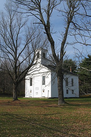
The Universalist Society Meetinghouse is an historic Greek Revival meetinghouse at 3 River Road in Orleans, Massachusetts. Built in 1834, it was the only Universalist church built in Orleans, and is architecturally a well-preserved local example of Greek Revival architecture. The Meeting House is now the home of the Orleans Historical Society and is known as the Meeting House Museum. It was listed on the National Register of Historic Places in 1999.

The Fiske House is a historic house located at 1 Billerica Road in Chelmsford Center, Massachusetts, US.

The Old Centre Historic District is a historic district encompassing the historic town center of Winchendon, Massachusetts. It includes the town's first cemetery, the First Congregational Church, and the oldest surviving house in town, and only one building constructed after 1850. The district was added to the National Register of Historic Places in 1987.

The Harvard Center Historic District is a historic district encompassing the traditional village center of Harvard, Massachusetts, USA. The district is centered on the town common, a triangular grassy space bounded by Elm Street, Still River Road, and Ayer Road. The common is ringed by residences, civic and religious buildings, and a small commercial area. The common was laid out when the town was founded in 1732, and has grown, mainly in periods of growth at the late 18th and late 19th/early 20th centuries. Most of the village's buildings post-date 1831. The district was added to the National Register of Historic Places in 1997.

The Cohasset Common Historic District is a historic district encompassing the historic town center of Cohasset, Massachusetts. It is centered on the town common, which is bounded by Highland Ave., N. Main St., William B. Long, Jr., Rd. and Robert E. Jason Road. The district was added in 1996 to the National Register of Historic Places.

The Teaticket School is a historic former school building at 340 Teaticket Hwy in Falmouth, Massachusetts. Built in 1927, this large Colonial Revival building was the first consolidated elementary school in the town. It has since 1967 served as the Administration Building for the Falmouth Public Schools. It was listed on the National Register of Historic Places in 2002.

The Williamsburg Center Historic District is a historic district on Massachusetts Route 9 in Williamsburg, Massachusetts. It encompasses the traditional center of the town, which was settled in the 18th century and grew to prosperity in the mid-19th century. It was listed on the National Register of Historic Places in 1980.
The Ware Center Historic District encompasses the historic early center of Ware, Massachusetts. Centered at the junction of Massachusetts Route 9 with Greenwich Plains Road, it is a linear district extending about 0.5 miles (0.80 km) along Route 9 in either direction. Most of the structures in the district were built between 1760 and 1860, although there are some 20th century intrusions. The area was the center of town civic and commercial activity until the 1820s, when villages serving industry became more important. The district was listed on the National Register of Historic Places in 1986.

The Chester Center Historic District is a historic district encompassing the historic center of Chester, Massachusetts. The area was first laid out by Chester's first settlers in 1763. It remained the center of commerce and civic life in the rural agricultural community until railroads were built in other areas of the town in the 1840s. The village center declined in importance as economic activity moved to areas more readily accessible to the railroad, and the town hall was eventually moved to Chester Factories. The district includes properties on Skyline Trail near the intersection of Bromley and Lyman Roads, and features Greek Revival, colonial, and Federal architecture. It was listed on the National Register of Historic Places in 1988.

The Ludlow Center Historic District encompasses the historic village center of Ludlow, Massachusetts. Centered on the junction of Center, Church and Booth Streets, it is the site selected as the town center when Ludlow was established in 1774. Its notable structures include the Congregational Church, the old town hall, and a number of farmhouses that date to the first half of the 19th century. The area has remained a center of civic life in the town, even though its economic center moved later in the 19th century to Ludlow Village. The district was listed on the National Register of Historic Places in 1988.

The Acton Center Historic District encompasses the historic heart of the once-rural, now suburban, town of Acton, Massachusetts. The district includes properties on Main Street, Wood and Woodbury Lanes, Newtown, Concord, and Nagog Hill Roads, and has been the town's civic heart since its establishment in the 1730s. It was added to the National Register of Historic Places in 1983.

The South Green Historic District encompasses one of the oldest central civic parts of Ipswich, Massachusetts. The town's South Green was laid out in 1686, and is now the heart of a collection of historic properties dating from the 17th to the 19th century. The centerpiece of the district is the green itself, and its most notable associated property is the John Whipple House, a National Historic Landmark and museum. The district boundaries extend from the junction of South Main and Elm Streets, southward past the green to where County Road crosses Saltonstall's Creek.
The Topsfield Town Common District encompasses the historic town common and surrounding buildings in Topsfield, Massachusetts. The common, established by 1650, is the traditional civic and religious center of the town, and is surrounded by houses dating from the 17th to 20th centuries, the town hall, library, and Congregational church. It was added to the National Register of Historic Places in 1976.

The Bedford Center Historic District encompasses the historic heart of the town of Bedford, Massachusetts. It extends along Great Road between Bacon and Concord Roads, and includes primarily residential areas on adjacent side streets. The area includes the town's main civic buildings, its first cemetery, and a diverse array of residential architecture spanning more than two centuries. The district was listed on the National Register of Historic Places in 1977; its boundaries were adjusted in 2014 and its period of significance extended.

The Billerica Mills Historic District is a historic district between the Concord River, Treble Cove Terrace, Kohlrausch Avenue, Indian Road, Holt Ruggles, and Rogers Streets in the village of North Billerica, Massachusetts.
The Lincoln Center Historic District is a historic district on Bedford, Lincoln, Old Lexington, Sandy Pond, Trapelo & Weston Roads in Lincoln, Massachusetts. The district encompasses Lincoln's civic heart, consisting of a traditional New England Meeting House, a Late Victorian church and the Lincoln Public Library, and a Georgian Revival town hall, as well as a cluster of residences dating to the mid-18th century, when Lincoln was established as a town separate from its neighbors.

The Natick Center Historic District is a historic district on North Ave., Main, Central, and Summer Streets in Natick, Massachusetts, encompassing the 19th century civic and economic heart of the town. Natick's early colonial center, dating to 1651, was in South Natick, and the area that is now its center was a parcel of land set aside for the minister. It achieved significant prominence with the construction of a meeting house in 1799, and the land was sold off for development in 1812. The Boston and Worcester Railroad was extended through the town center in 1835, spurring economic growth. After a fire in 1874 destroyed most of the central business district, the present collection of brick Gothic and Romanesque buildings was constructed.

The Abraham Jaquith House, also known as Farley Garrison house, is a house at 1246 Province Road in Gilmanton, New Hampshire. Built about 1725 in Billerica, Massachusetts, it was dismantled and moved to its present location in the early 2000s. It was listed on the National Register of Historic Places in 1991, and was delisted in 2024.

The Howe School is a historic school building at 390 Boston Road in Billerica, Massachusetts. This three story brick building was built in 1852 with funding from a bequest by Zadok Howe, and served the town as a secondary educational institution for 100 years. Designed by Daniel G. Bean of Lowell, the building including an innovative ventilation system for bringing warm and fresh air into the classrooms. At first a private academy, it was designated the town's high school in 1896, and later served as a grade school and as school administration offices.

The Brookline Town Green Historic District encompasses the historic colonial heart of the town of Brookline, Massachusetts. Centered on a stretch of Walnut Street between Warren and Chestnut Streets, this area is where the town's first colonial meeting house and cemetery were laid out, and was its center of civic life until the early 19th century. The district was listed on the National Register of Historic Places in 1980.


