It has been suggested that this article be merged into Compton Pauncefoot . (Discuss) Proposed since June 2018. |
Blackford and Compton Pauncefoot is a civil parish in Somerset, England.

In England, a civil parish is a type of administrative parish used for local government, they are a territorial designation which is the lowest tier of local government below districts and counties, or their combined form, the unitary authority. Civil parishes can trace their origin to the ancient system of ecclesiastical parishes which historically played a role in both civil and ecclesiastical administration; civil and religious parishes were formally split into two types in the 19th century and are now entirely separate. The unit was devised and rolled out across England in the 1860s.

Somerset is a county in South West England which borders Gloucestershire and Bristol to the north, Wiltshire to the east, Dorset to the south-east and Devon to the south-west. It is bounded to the north and west by the Severn Estuary and the Bristol Channel, its coastline facing southeastern Wales. Its traditional border with Gloucestershire is the River Avon. Somerset's county town is Taunton.
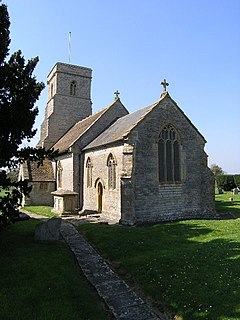
The parish covers the villages of Blackford and Compton Pauncefoot.

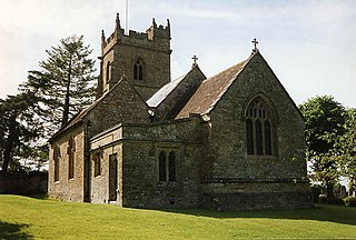
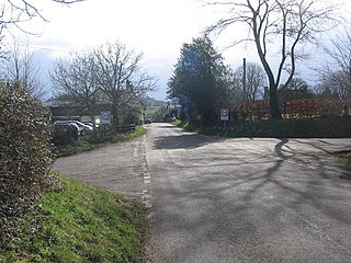
Blackford is a village and former civil parish in the county of Somerset, England, situated beside the A303 road, 4 miles (6.4 km) south west of Wincanton in the South Somerset district. There are two other places called Blackford in Somerset — one is a village near Wedmore, the other a tiny hamlet between Porlock and Minehead.

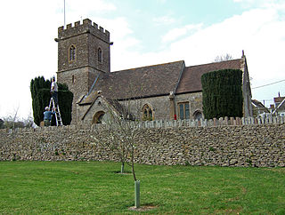
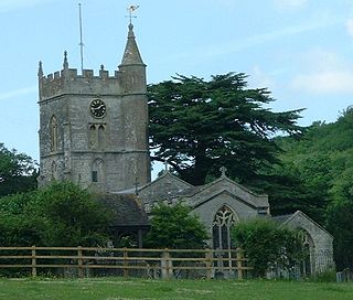
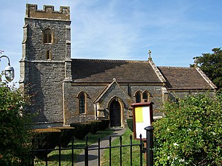
Compton Pauncefoot is a village and civil parish in Somerset, England, situated beside the A303 road, 5 miles (8.0 km) south west of Wincanton in the South Somerset district. The parish had a population of 139 in 2011. The civil parish also includes the village with Blackford and therefore population is based on the two villages together. Blackford parish was merged with Compton Pauncefoot on the 1 April 1933. The civil parish holds a Parish Meeting twice a year and has no Parish Council.
The parish has no parish council and has a Parish Meeting which has limited responsibility for local issues, including setting an annual precept (local rate) to cover very limited permitted expenditure (basically minimal operating expenses and contribution to burial authority) and producing annual accounts for public scrutiny. The parish meeting helps evaluate local planning applications and works with the local police, district council officers, and neighbourhood watch groups on matters of crime, security, and traffic. The parish meeting's role also includes liaising with the district council over projects for the maintenance and repair of parish facilities, as well as consulting with the district council on the maintenance, repair, and improvement of highways, drainage, footpaths, public transport, and street cleaning. Conservation matters (including trees and listed buildings) and environmental issues are also matters that the parish meeting has a say on but no formal responsibility.
The village falls within the Non-metropolitan district of South Somerset, which was formed on 1 April 1974 under the Local Government Act 1972, having previously been part of Wincanton Rural District, [1] which is responsible for local planning and building control, local roads, council housing, environmental health, markets and fairs, refuse collection and recycling, cemeteries and crematoria, leisure services, parks, and tourism.
Non-metropolitan districts, or colloquially "shire districts", are a type of local government district in England. As created, they are sub-divisions of non-metropolitan counties in a two-tier arrangement.
South Somerset is a local government district in Somerset, England.

The Local Government Act 1972 is an Act of the Parliament of the United Kingdom that reformed local government in England and Wales on 1 April 1974.
Somerset County Council is responsible for running the largest and most expensive local services such as education, social services, libraries, major roads (except trunk routes such as the A303 which is the responsibility of the Highways Agency), public transport, policing and fire services, trading standards, waste disposal and strategic planning.

Somerset County Council is the county council of Somerset in the South West of England, an elected local government authority responsible for the most significant local government services in most of the county. Somerset County Council plans drastic cuts to services because the government has cut funding and the council cannot balance its books.
Social services are a range of public services provided by the government, private, profit and non-profit organizations. These public services aim to create more effective organizations, build stronger communities, and promote equality and opportunity.

A library is a collection of sources of information and similar resources, made accessible to a defined community for reference or borrowing. It provides physical or digital access to material, and may be a physical building or room, or a virtual space, or both. A library's collection can include books, periodicals, newspapers, manuscripts, films, maps, prints, documents, microform, CDs, cassettes, videotapes, DVDs, Blu-ray Discs, e-books, audiobooks, databases, and other formats. Libraries range in size from a few shelves of books to several million items. In Latin and Greek, the idea of a bookcase is represented by Bibliotheca and Bibliothēkē : derivatives of these mean library in many modern languages, e.g. French bibliothèque.
It is also part of the Somerton and Frome, a county constituency represented in the House of Commons of the Parliament of the United Kingdom. It elects one Member of Parliament (MP) by the first past the post system of election, and part of the South West England constituency of the European Parliament which elects seven MEPs using the d'Hondt method of party-list proportional representation.

Somerton and Frome is a constituency represented in the House of Commons of the UK Parliament since 2015 by David Warburton of the Conservative Party.

The Parliament of the United Kingdom of Great Britain and Northern Ireland, commonly known internationally as the UK Parliament, British Parliament, or Westminster Parliament, and domestically simply as Parliament, is the supreme legislative body of the United Kingdom, the Crown dependencies and the British Overseas Territories. It alone possesses legislative supremacy and thereby ultimate power over all other political bodies in the UK and the overseas territories. Parliament is bicameral but has three parts, consisting of the Sovereign, the House of Lords, and the House of Commons. The two houses meet in the Palace of Westminster in the City of Westminster, one of the inner boroughs of the capital city, London.

South West England is a constituency of the European Parliament. From 2009 it elects 6 MEPs using the d'Hondt method of party-list proportional representation, reduced from 7 in 2009.