Brympton

Last updated

Brympton
Brympton Clock tower.png
The Brympton clock tower
Somerset UK location map.svg
Red pog.svg
Brympton
Location within Somerset
Population7,308 (2011) [1]
OS grid reference ST520155
District
Shire county
Region
Country England
Sovereign state United Kingdom
Post town YEOVIL
Postcode district BA22
Dialling code 01935
Police Avon and Somerset
Fire Devon and Somerset
Ambulance South Western
UK Parliament
List of places
UK
England
Somerset
50°56′13″N2°41′01″W / 50.9370°N 2.6835°W / 50.9370; -2.6835 Coordinates: 50°56′13″N2°41′01″W / 50.9370°N 2.6835°W / 50.9370; -2.6835

Brympton is a civil parish and electoral ward in Somerset, England. The parish is situated on the north-west edge of Yeovil in the South Somerset district. The parish/ward has a population of 7,308. [1] The civil parish covers the western part of the Yeovil built up area, including the stadium of Yeovil Town F.C. at Huish Park, and also includes the hamlets of Brympton D'Evercy, Lufton, Thorne Coffin and Alvington as well as part of Chilthorne Domer.

Contents

History

An important late Roman villa was excavated at Lufton by Leonard Hayward of Yeovil Grammar School during the 1950s and 1960s. [2] Further work on this villa and its landscape was undertaken by archaeologists from Newcastle University between 2012 and 2017. [3] The villa is a corridor building with an unusual octagonal plunge bath. A number of mosaics were found, including one around the octagonal pool depicting fish. [4]

Brympton, historically spelt Brimpton, was an ancient parish, part of the Stone Hundred. [5] The parish included the historic manor house known as Brympton d'Evercy, and the hamlets of Alvington and Houndstone. It became a civil parish in 1866. In 1930 the parish absorbed part of the civil parish of Preston Plucknett, which was abolished. [6]

Lufton was also an ancient parish, part of the Stone Hundred. In 1866 it became a civil parish, which was abolished in 1933 and absorbed into the civil parish of Brympton. [7] Lufton Manor, which dates from 1900 is an example of Queen Anne style architecture. It was designed by architect Evelyn Hellicar (1862-1929). [8] It is a grade II listed building.

Thorne Coffin was an ancient parish in the Tintinhull Hundred. [5] In 1866 it became a civil parish, which was abolished in 1933 and absorbed into the civil parish of Brympton. [9]

Governance

The parish council has responsibility for local issues, including setting an annual precept (local rate) to cover the council's operating costs and producing annual accounts for public scrutiny. The parish council evaluates local planning applications and works with the local police, district council officers, and neighbourhood watch groups on matters of crime, security, and traffic. The parish council's role also includes initiating projects for the maintenance and repair of parish facilities, as well as consulting with the district council on the maintenance, repair, and improvement of highways, drainage, footpaths, public transport, and street cleaning. Conservation matters (including trees and listed buildings) and environmental issues are also the responsibility of the council.

The village falls within the Non-metropolitan district of South Somerset, which was formed on 1 April 1974 under the Local Government Act 1972, having previously been part of Yeovil Rural District. [10] The district council is responsible for local planning and building control, local roads, council housing, environmental health, markets and fairs, refuse collection and recycling, cemeteries and crematoria, leisure services, parks, and tourism.

Somerset County Council is responsible for running the largest and most expensive local services such as education, social services, libraries, main roads, public transport, policing and fire services, trading standards, waste disposal and strategic planning.

It is also part of the Yeovil county constituency represented in the House of Commons of the Parliament of the United Kingdom. It elects one Member of Parliament (MP) by the first past the post system of election, and was part of the South West England constituency of the European Parliament prior to Britain leaving the European Union in January 2020, which elected seven MEPs using the d'Hondt method of party-list proportional representation.

Religious sites

The Church of St. Andrew, the parish church of Brympton, dates from the 13th century and has been designated by English Heritage as a grade I listed building. [11]

The Church of St Andrew, the parish church of Thorne Coffin, was built in the 14th century. It is a Grade II* listed building. [12]

The Church of St Peter and St Paul, the parish church of Lufton, dates from the 14th century or earlier, but was rebuilt in 1865 by Benjamin Ferrey. It is a Grade II listed building. [13]

Related Research Articles

Yeovil Town in Somerset, England

Yeovil, a town and civil parish in the district of South Somerset, England, has a population of 45,000. It is close to Somerset's southern border with Dorset, 130 miles (210 km) from London, 40 miles (64 km) south of Bristol, 6 miles (9.7 km) from Sherborne and 30 miles (48 km) from Taunton. The aircraft and defence industries developed in the 20th century made it a target for bombing in the Second World War. They are still major employers. Yeovil Country Park, which includes Ninesprings, is one of several open spaces with educational, cultural and sporting facilities. Religious sites include the 14th-century Church of St John the Baptist. The town is on the A30 and A37 roads and has two railway stations.

South Cadbury Human settlement in England

South Cadbury is a village in the civil parish of South Cadbury and Sutton Montis, in the South Somerset council area of the English county of Somerset. The parish includes the village of Sutton Montis.

East Coker Village in Somerset, England

East Coker is a village and civil parish in the South Somerset district of Somerset, England. Its nearest town is Yeovil, two miles (3.2 km) to the north. The village has a population of 1,667. The parish includes the hamlets and areas of North Coker, Burton, Holywell, Coker Marsh, Darvole, Nash, Keyford as well as the southern end of the Wraxhill area.

Thornfalcon Human settlement in England

Thornfalcon is a village and civil parish in Somerset, England, situated 4 miles (6.4 km) east of Taunton in the Somerset West and Taunton district. The village has a population of 119. The parish includes the hamlet of Ash. The name comes from Thorn, and the personal name Fagun which was the Norman surname of Sir Gilbert of Thorn, whose family were lords of the manor until the 14th century.

Barrington, Somerset Human settlement in England

Barrington is a village and civil parish, situated 10 miles (16.1 km) south east of Taunton and 10 miles (16.1 km) west of Yeovil in the South Somerset district of Somerset, England. The village has a population of 438.

Broadway, Somerset Human settlement in England

Broadway is a village and civil parish in Somerset, England, situated 3 miles (4.8 km) west of Ilminster and 5 miles (8.0 km) north of Chard in the South Somerset district. The parish has a population of 740. The parish includes the nearby hamlet of Hare.

Closworth Human settlement in England

Closworth is a village and civil parish in Somerset, England, 5 miles (8.0 km) south of Yeovil in the South Somerset district, on the border with Dorset. The village has a population of 220.

Combe St Nicholas Human settlement in England

Combe St Nicholas is a village and parish in Somerset, England, situated 2 miles (3.2 km) northwest of Chard and 10 miles (16 km) from Taunton in the South Somerset district on the edge of the Blackdown Hills Area of Outstanding Natural Beauty. The parish, which includes Wadeford and Scrapton, has a population of 1,373.

Curry Rivel Human settlement in England

Curry Rivel is a village and civil parish in Somerset, England, situated 6 miles (9.7 km) west of Somerton and 10 miles (16.1 km) east of Taunton in the South Somerset district. The parish has a population of 2,148. The parish includes the hamlet of Burton Pynsent.

Dinnington, Somerset Human settlement in England

Dinnington is a village and civil parish in the English county of Somerset, situated 4 miles (6.4 km) north of Crewkerne in the South Somerset district. The village has a population of 65.

Hardington Mandeville Human settlement in England

Hardington Mandeville is a village and civil parish in Somerset, England, situated 3 miles (4.8 km) south west of Yeovil in the South Somerset district. The village has a population of 585.

Marston Magna Human settlement in England

Marston Magna is a village and civil parish in Somerset, England, situated 5 miles (8.0 km) north of Yeovil in the South Somerset district. The village has a population of 523.
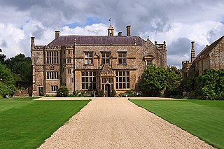
Tintinhull Human settlement in England

Tintinhull is a village and civil parish near Yeovil, 2.5 miles (4 km) south west of Ilchester, in Somerset, England. The village is close to the A303. It is on the Fosse Way.

Odcombe Human settlement in England

Odcombe is a village and civil parish in south Somerset, England, 3 miles (4.8 km) west of the town of Yeovil, with a population of 759 in 2011.

Rimpton Human settlement in England

Rimpton is a village and civil parish 5 miles (8 km) north-west of Sherborne, and 6 miles (10 km) north-east of Yeovil on a tributary of the River Parret in the South Somerset district of Somerset, England.

Stawell, Somerset Human settlement in England

Stawell is a village and civil parish 4.5 miles (7 km) north-east of Bridgwater, and 2 miles (3 km) north-west of Moorlinch, in the Sedgemoor district of Somerset, England. The civil parish includes the village of Sutton Mallet.

Whitestaunton Human settlement in England

Whitestaunton is a village and civil parish in the South Somerset district of Somerset, England. The parish includes the hamlet of Northay. It was known simply as Staunton until the 14th century.

St Andrews Church, Brympton

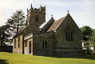
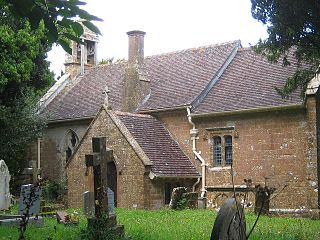
The Church of St Andrew in Brympton, Somerset, England, dates from the 13th century and has been designated as a Grade I listed building.

The Hundred of Stone is one of the 40 historical Hundreds in the ceremonial county of Somerset, England, dating from before the Norman conquest during the Anglo-Saxon era although exact dates are unknown. Each hundred had a 'fyrd', which acted as the local defence force and a court which was responsible for the maintenance of the frankpledge system. They also formed a unit for the collection of taxes. The role of the hundred court was described in the Dooms (laws) of King Edgar. The name of the hundred was normally that of its meeting-place.

Church of St Andrew, Thorne Coffin

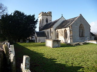
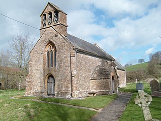
The Church of St Andrew in Thorne Coffin, Somerset, England was built in the 14th century. It is a Grade II* listed building.

References

  1. 1 2 "Statistics for Wards, LSOAs and Parishes — SUMMARY Profiles" (Excel). Somerset Intelligence. Retrieved 4 January 2014.
  2. Hayward, Leonard (1972). "The Roman villa at Lufton, Near Yeovil". Proceedings of the Somerset Archaeological and Natural History Society. 116: 59–77.
  3. Newcastle, University (2021). "The Lufton Project".
  4. "Roman villa, N of Lufton". Somerset Historic Environment Record. Somerset County Council. Retrieved 21 September 2014.
  5. 1 2 "Somerset Hundreds". GENUKI. Retrieved 22 October 2011.
  6. Great Britain Historical GIS / University of Portsmouth, Brympton CP/AP . Retrieved 9 February 2021.
  7. Great Britain Historical GIS / University of Portsmouth, Lufton CP/AP . Retrieved 9 February 2021.
  8. Hellicar obituary, Journal of the RIBA, 21 September 1929 page 772
  9. Great Britain Historical GIS / University of Portsmouth, Thorne CP/AP . Retrieved 9 February 2021.
  10. "Yeovil RD". A vision of Britain Through Time. University of Portsmouth. Retrieved 4 January 2014.
  11. Historic England. "Church of St Andrew (1057269)". National Heritage List for England . Retrieved 6 December 2007.
  12. Historic England. "Church of St Andrew (1263070)". National Heritage List for England . Retrieved 9 February 2021.
  13. Historic England. "Church of St Peter and St Paul (1345771)". National Heritage List for England . Retrieved 9 February 2021.