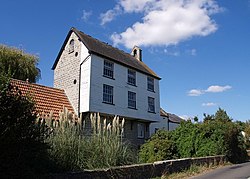
Hambridge and Westport | |
---|---|
Hambridge Mill House | |
Location within Somerset | |
Population | 514 (2011) [1] |
OS grid reference | ST395215 |
District | |
Shire county | |
Region | |
Country | England |
Sovereign state | United Kingdom |
Post town | Langport |
Postcode district | TA10 |
Dialling code | 01460 |
Police | Avon and Somerset |
Fire | Devon and Somerset |
Ambulance | South Western |
UK Parliament | |
Hambridge and Westport is a civil parish in Somerset, England. It had a population of 514 in 2011. [1] The parish includes the villages of Hambridge and Westport, and is in the South Somerset district.
Westport lies on the disused Westport Canal and Hambridge lies close to its junction with the River Isle.
Hambridge is most notable as the place at which Cecil Sharp was inspired by the Rev. Charles Marson, Vicar of Hambridge, to begin collecting folk songs.
The two villages, Hambridge and Westport share many resources including Parish Council, Church (the Church of St James the Less), Branch of the Royal British Legion and Recreation Trust who manage a recreation ground and Village Hall.
There is a thriving school and many additional clubs and societies use the Village Hall as a meeting venue. The Hall is often used for wedding receptions and for celebration events of all kinds. It has panoramic views across the Somerset Levels towards Burrow Hill.
The parish council has responsibility for local issues, including setting an annual precept (local rate) to cover the council's operating costs and producing annual accounts for public scrutiny. The parish council evaluates local planning applications and works with the local police, district council officers, and neighbourhood watch groups on matters of crime, security, and traffic. The parish council's role also includes initiating projects for the maintenance and repair of parish facilities, as well as consulting with the district council on the maintenance, repair, and improvement of highways, drainage, footpaths, public transport, and street cleaning. Conservation matters (including trees and listed buildings) and environmental issues are also the responsibility of the council.
The parish falls within the Non-metropolitan district of South Somerset, which was formed on 1 April 1974 under the Local Government Act 1972, having previously been part of Langport Rural District. [2] The district council is responsible for local planning and building control, local roads, council housing, environmental health, markets and fairs, refuse collection and recycling, cemeteries and crematoria, leisure services, parks, and tourism.
Somerset County Council is responsible for running the largest and most expensive local services such as education, social services, libraries, main roads, public transport, policing and fire services, trading standards, waste disposal and strategic planning.
It is also part of the Glastonbury and Somerton county constituency represented in the House of Commons of the Parliament of the United Kingdom. It elects one Member of Parliament (MP) by the first past the post system of election.
Charlton Mackrell is a village and former civil parish, now in the parish of The Charltons, in the Somerset district, in the ceremonial county of Somerset, England, situated 3 miles (5 km) east of Somerton. The village has a population of 1,020.
Compton Dundon is a village and civil parish in Somerset, England, lying beside King's Sedgemoor and the Polden Hills, 5 miles (8 km) south of Glastonbury and 4 miles (6 km) north of Somerton in the South Somerset district. The village has a population of 705. The parish includes the small village of Dundon and the hamlet of Littleton.
Curry Mallet is a village and parish in Somerset, England. It is on the Fivehead River, 7 miles (11.3 km) east of Taunton in the South Somerset district. The village has a population of 306.
Curry Rivel is a village and civil parish in Somerset, England, situated 6 miles (9.7 km) west of Somerton and 10 miles (16.1 km) east of Taunton in the South Somerset district. The parish has a population of 2,148. The parish includes the hamlet of Burton Pynsent.
Drayton is a village and civil parish in Somerset, England, focussed less than a mile from Curry Rivel and five miles southwest of Somerton in the South Somerset district. It adjoins the River Isle, near its confluence with the Parrett, and the former Westport Canal. The parish includes the hamlet of Midelney.
Fivehead is a village and civil parish in Somerset, England, situated on the Fivehead River, 8 miles (12.9 km) east of Taunton in the South Somerset district. In 2011 the parish, which includes the hamlet of Swell, had a population of 609.
High Ham is a village and civil parish in Somerset, England. Within the parish of High Ham, there are the villages of High Ham and Low Ham and the hamlets of Bowdens, Henley, Paradise and Picts Hill.
Horsington is a village and civil parish in Somerset, England, situated 4 miles (6.4 km) south of Wincanton and 1 mile (1.6 km) north of Templecombe in the South Somerset district. The village lies on the edge of Horsington Marsh, part of the Blackmore Vale. In 2011 the population of the Parish, which includes the adjoining hamlets of Peckholdsash and Wilkin Throop and the village of South Cheriton was 571.
Ilton is a village and civil parish in Somerset, England, situated 8 miles (12.9 km) south-east of Taunton, and 2 miles (3.2 km) north of Ilminster in the South Somerset district. The village has a population of 854. The parish includes the hamlets of Ilford and Cad Green with its 16th-century almshouses.
Isle Abbots is a village and civil parish in Somerset, England, around 7 miles (11.3 km) south-east of Taunton in the South Somerset district. The village had a population of 205 at the 2011 census.
Isle Brewers is a village and parish in Somerset, England, situated on the River Isle, 7 miles (11.3 km) south east of Taunton in the South Somerset district. The village has a population of 150. The parish includes the hamlet of North Bradon.
Kingsdon is a village and parish in the South Somerset district of Somerset, England, situated 3 miles (4.8 km) south east of Somerton. The village has a population of 303 but this is set to rise to around 350 once the Kingsdon Manor development is complete. The majority of the houses in the village are clustered on the side of the hill from which there are scenic views across the Somerset countryside.
Kingweston is a village and civil parish in Somerset, England, situated on Combe Hill, 3 miles (4.8 km) north east of Somerton in the South Somerset district. The village has a population of 128.
Long Load is a village and parish in Somerset, England, situated on the River Yeo 5 miles (8.0 km) south of Somerton in the South Somerset district. The village has a population of 332.
Pitney is a village and parish in Somerset, England, located 2.5 miles (4.0 km) east of Langport and 3 miles (4.8 km) west of Somerton in the South Somerset district. In 2011, the village had a population of 374.
Wootton Courtenay is a village and civil parish on Exmoor in the Somerset West and Taunton district of Somerset, England. The parish includes the hamlets of Brockwell and Huntscott.
Wambrook is a village and civil parish in the Blackdown Hills, Somerset, England. The village lies about 2 miles (3 km) southwest of the town of Chard. The parish includes the hamlets of Higher Wambrook and Lower Wambrook which is sometimes known as Haselcombe.
Puckington is a village and civil parish, situated 10 miles (16 km) south-east of Taunton and 10 miles (16 km) west of Yeovil in Somerset, England. The parish includes the hamlet of South Bradon. In 2011 the parish had a population of 117.
North Barrow is a village and civil parish 8 miles (13 km) to the north-east of Ilchester in the South Somerset district of Somerset, England.
Yeovil Without is a civil parish in the South Somerset district of Somerset, England.