East Coker

Last updated • 6 min readFrom Wikipedia, The Free Encyclopedia

East Coker
East Coker Church - geograph.org.uk - 542241.jpg
Somerset UK location map.svg
Red pog.svg
East Coker
Location within Somerset
Population1,667 (2011) [1]
OS grid reference ST545125
District
Shire county
Region
Country England
Sovereign state United Kingdom
Post town YEOVIL
Postcode district BA22
Dialling code 01935
Police Avon and Somerset
Fire Devon and Somerset
Ambulance South Western
UK Parliament
List of places
UK
England
Somerset
50°54′36″N2°38′55″W / 50.9101°N 2.6485°W / 50.9101; -2.6485
Millennium Stone, East Coker Millennium Stone East Coker - geograph.org.uk - 947422.jpg
Millennium Stone, East Coker

East Coker is a village and civil parish in the South Somerset district of Somerset, England. Its nearest town is Yeovil, two miles (3.2 km) to the north. The village has a population of 1,667. [1] The parish includes the hamlets and areas of North Coker, Burton, Holywell, Coker Marsh, Darvole, Nash, Keyford as well as the southern end of the Wraxhill area.

Contents

History

The East Coker Mosaic on display at the Museum of Somerset East Coker Mosaic.JPG
The East Coker Mosaic on display at the Museum of Somerset

A Roman villa was discovered in East Coker in the 18th century and subsequent excavation has discovered artefacts including a mosaic; however, further work is needed to fully identify the plan of the building. [2]

In the Domesday Survey of 1086 the villages of West and East Coker were known as Cocre. [3]

The parish was part of the hundred of Houndsborough. [4]

The Manor of East Coker was held by the Courtenay family of Powderham from 1306 until 1591. They built Coker Court as the manor house which was eventually sold to Edward Phelips, a wealthy landowner in the region. Upon Edward's death, the manor was left to his trustee, William Helyar, whose family it descended into for the next 300 years. After the last Helyar heir died in the first half of the 20th century, the lordship was acquired by a descendant of the Courtenay family who is the current lord of the manor. [5]

In 1645, soon after the English Civil War, 70 people in the village died of the plague. [6]

In 2011 South Somerset Council published a plan for local housing which included a proposal for the construction of 3,700 new houses on land between East Coker and Yeovil. [7] Local opposition has been vocal. [8] It included an application, supported by Andrew Motion, for World Heritage Site listing based on associations with T. S. Eliot, who wrote the poem East Coker , the second of his "Four Quartets" in 1940 after a visit to the village. [9]

Governance

The parish council has responsibility for local issues, including setting an annual precept (local rate) to cover the council's operating costs and producing annual accounts for public scrutiny. The parish council evaluates local planning applications and works with the local police, district council officers, and neighbourhood watch groups on matters of crime, security, and traffic. The parish council's role also includes initiating projects for the maintenance and repair of parish facilities, as well as consulting with the district council on the maintenance, repair, and improvement of highways, drainage, footpaths, public transport, and street cleaning. Conservation matters (including trees and listed buildings) and environmental issues are also the responsibility of the council.

The village falls within the Non-metropolitan district of South Somerset, which was formed on 1 April 1974 under the Local Government Act 1972, having previously been part of Yeovil Rural District. [10] The district council is responsible for local planning and building control, local roads, council housing, environmental health, markets and fairs, refuse collection and recycling, cemeteries and crematoria, leisure services, parks, and tourism.

Somerset County Council is responsible for running the largest and most expensive local services such as education, social services, libraries, main roads, public transport, policing and fire services, Trading Standards, waste disposal and strategic planning.

It is also part of the Yeovil county constituency represented in the House of Commons of the Parliament of the United Kingdom. It elects one Member of Parliament (MP) by the first past the post system of election. Prior to Brexit in 2020, it was part of the South West England constituency of the European Parliament.

Landmarks

Coker Court was built as a 15th-century manor house, and is now divided into several properties. The 18th-century portion was built by Sir William Chambers. It was used as Clare School at one time. It is listed Grade I. [11]

Helyar Almshouses built between 1640 and 1660.

Hymerford House (also known as Grove Farmhouse) dates from the 15th century and is listed Grade I. [12]

Naish Priory listed Grade I contains extant portions of a substantial and important establishment that was part of the manor of Coker and dates from the 14th century. [13]

Transport

The parish has no railway station, the nearest being Yeovil Junction railway station on the Exeter-London Waterloo line which passes through the parish. Previously the village was served by Sutton Bingham Station which was about one kilometre south of the village and closed to all traffic on 31 December 1962. There are a few bus routes, these are Route N8 (Nippy Bus) West Coker-Yeovil which operates hourly Monday to Friday Daytime between 8am and 5pm [14] Route X37 (Sureline) Yeovil-Dorchester operates one journey in this direction only Monday to Friday Yeovil College Term time Only at 0927 arriving at Dorchester at 1020 in combination with a return service Route 212 (Sureline) Dorchester-Yeovil operates one journey in this direction only Monday to Friday Yeovil College Term time Only leaving Dorchester at 1200 arriving back in East Coker at 1314. [15] The parish also has some innovative demand responsive transport provided by Nippy Bus, the N8 can be booked to pick up passengers off route in the parish after first registering and calling the company an hour before travel and will arrange a convenient time within the hours of operation to pick people up. There is also a night bus service Route N4 Crewkerne-Yeovil which operates on a demand responsive basis Wednesday-Saturday Nights, last journey from Yeovil Thursday-Saturday Nights is at 0250 in the early hours of the morning arriving in the parish around 0330. [16]

Industry

Coker Canvas. [17] Samuel Hutchings of East Coker, sail cloth manufacturer in 1828. [18] Sail cloth manufacturing in the 18th and 19th century. John Bullock of East Coker, sail cloth manufacturer 1740's - 1780's (father and son). [19]

Religious sites

Lychgate East Coker Cemetery Lychgate East Coker Cemetery - geograph.org.uk - 947372.jpg
Lychgate East Coker Cemetery

The church of St Michael in East Coker dates from the 12th century and has been designated by English Heritage as a Grade II* listed building. [20] The church is the final resting place of the ashes of T. S. Eliot, whose ancestors came from the village. [21]

Notable residents

Notable trees

Ulmus minor tree.jpg

A superb specimen of the narrow-leaved (or smooth-leaved) elm Ulmus minor subsp. minor survives, unscathed by Dutch elm disease, in a pasture to the south-east of the village. Measured in 2008, it was more than 30 m in height, with a d.b.h. of 85 cm. Almost certainly planted as one of many ornamentals by the Helyar dynasty, the tree is a TROBI UK Champion, and has been adjudged the finest freestanding specimen in Europe. [26]

The tree has been cloned at Le Pépinière Forestière de L'etat, Guémené-Penfao, France, as part of the Euforgen genetic resources conservation programme. [27]

Related Research Articles

<span class="mw-page-title-main">Yeovil</span> Town in Somerset, England

Yeovil is a town and civil parish in Somerset, England. The population of Yeovil at the last census (2021) was 49,698. It is close to Somerset's southern border with Dorset, 126 miles (203 km) west of London, 41.8 miles (67.3 km) south of Bristol, 6 miles (9.7 km) west of Sherborne and 27.6 miles (44.4 km) east of Taunton. The aircraft and defence industries which developed in the 20th century made it a target for bombing in the Second World War; they are still major employers. Yeovil Country Park, which includes Ninesprings, is one of several open spaces with educational, cultural and sporting facilities. Religious sites include the 14th-century Church of St John the Baptist. The town is on the A30 and A37 roads and has two railway stations.

<span class="mw-page-title-main">Crewkerne</span> Human settlement in England

Crewkerne is a town and electoral ward in south Somerset, England, 9 miles (14 km) southwest of Yeovil and 7 miles (11 km) east of Chard. The civil parish of West Crewkerne includes the hamlets of Coombe, Woolminstone and Henley, and borders the county of Dorset to the south. The town is on the main headwater of the River Parrett, A30 road and West of England Main Line railway, in modern times the slower route between the capital and the southwest peninsula, having been eclipsed by the Taunton route.

<span class="mw-page-title-main">Yeovilton</span> Village in Somerset, England

Yeovilton is a village in Somerset, England, 1 mile (1.6 km) east of Ilchester and 5 miles (8.0 km) north of Yeovil. It had a population of 1,226 in the 2011 census, estimated at 1,418 in 2019.

<span class="mw-page-title-main">Dowlish Wake</span> Human settlement in England

Dowlish Wake is a small village and civil parish in Somerset, England, 2 miles (3 km) south of Ilminster and 5 miles (8 km) northeast of Chard in the South Somerset district. With a population of 277, it has several thatched houses and a pub, the New Inn. Its post office closed in 1991.

<span class="mw-page-title-main">Haselbury Plucknett</span> Human settlement in England

Haselbury Plucknett is a village and civil parish on the River Parrett in Somerset, England, situated 6 miles (9.7 km) south west of Yeovil in the South Somerset district. The village has a population of 744.

<span class="mw-page-title-main">Marston Magna</span> Human settlement in England

Marston Magna is a village and civil parish in Somerset, England, situated 5 miles (8.0 km) north of Yeovil in the South Somerset district. The village has a population of 523.

<span class="mw-page-title-main">Mudford</span> Village in England

Mudford is a village and parish in Somerset, England, situated 3 miles (4.8 km) from Yeovil in the South Somerset district on the River Yeo. The village has a population of 696. The parish includes the hamlets of Mudford Sock, West Mudford and Up Mudford.

<span class="mw-page-title-main">West Camel</span> Village in Somerset, England

West Camel is a village and civil parish in south Somerset, England, about 7 miles (11.3 km) north of the town of Yeovil. It lies either side of the River Cam, just south of the A303, and has a population of 459. The parish includes the hamlet of Urgashay. Neighbouring villages include Queen Camel, and Bridgehampton.

<span class="mw-page-title-main">West Coker</span> Human settlement in England

West Coker is a large village and civil parish in Somerset, England, situated 3 miles (4.8 km) south west of Yeovil in the South Somerset district.

<span class="mw-page-title-main">Sparkford</span> Village in Somerset, England

Sparkford is a village and civil parish in Somerset, England. The parish includes the village of Weston Bampfylde.

<span class="mw-page-title-main">Misterton, Somerset</span> Human settlement in England

Misterton is a village and civil parish 1 mile (1.6 km) south-east of Crewkerne, Somerset, England.

<span class="mw-page-title-main">North Perrott</span> Human settlement in England

North Perrott is a village and civil parish in south Somerset, England, near the border with Dorset.

<span class="mw-page-title-main">South Petherton</span> Village and civil parish in Somerset, England

South Petherton is a large village and civil parish in the South Somerset district of Somerset, England, located 5 miles (8 km) east of Ilminster and 5 miles (8 km) north of Crewkerne. The parish had a population of 3,737 in 2021 and includes the smaller village of Over Stratton and the hamlets of Compton Durville, Drayton, Wigborough and Yeabridge. The River Parrett forms the eastern boundary of the parish. The village is approximately 2 miles (3 km) from East Lambrook, Martock and Lopen.

<span class="mw-page-title-main">Coker Court</span> Historic site in Somerset, England

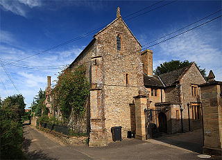
Coker Court is a substantial manor house in East Coker, Somerset, England. It was built in the fifteenth and eighteenth centuries and has been designated as a Grade I listed building. It was erected by the Courtney family who were lords of the manor and rectors of the adjacent parish church. The building is constructed from locally quarried Hamstone with roofs composed of stone tiles.

<span class="mw-page-title-main">Naish Priory</span> Historic site in Somerset, England

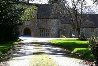
Naish Priory in East Coker, Somerset, England, contains portions of a substantial house dating from the mid 14th century to around 1400. Emery says the building was not a priory as it had been termed by the late 19th-century owner Troyte Chafyn Grove, and there appears no evidence of ownership by a religious house or the residence of a large community of monks on the site. However, there is evidence of a dormitory and communal living dating from the 14th century, and the extant buildings grew on a foundation that had religious obligations by way of chantry to the de Courtenay Earls of Devon from at least 1344. It has been designated as a Grade I listed building, with the attached Priory Cottage and northern boundary railings.

<span class="mw-page-title-main">Transport in Somerset</span> Overview of transport in Somerset

The earliest known infrastructure for transport in Somerset is a series of wooden trackways laid across the Somerset Levels, an area of low-lying marshy ground. To the west of this district lies the Bristol Channel, while the other boundaries of the county of Somerset are along chains of hills that were once exploited for their mineral deposits. These natural features have all influenced the evolution of the transport network. Roads and railways either followed the hills, or needed causeways to cross the Levels. Harbours were developed, rivers improved, and linked to sources of traffic by canals. Railways were constructed throughout the area, influenced by the needs of the city of Bristol, which lies just to the north of Somerset, and to link the ports of the far south-west with the rest of England.

<span class="mw-page-title-main">South West Coaches</span>

South West Coaches is a privately owned bus company that operates services around Dorset, Somerset, and Wiltshire, in South West England.

<span class="mw-page-title-main">Nippy Bus</span>

Nippy Bus was a privately owned bus company operating services in Somerset, England. It operated local town services in Yeovil under contract to the Somerset County Council as well as rural services. Nippy Club was launched in 2010 utilising a coach on chartered services twice a month for clubbers.

<span class="mw-page-title-main">Marcus Fysh</span> British politician

Marcus John Hudson Fysh is a British politician and former investment manager who was the Member of Parliament (MP) for Yeovil from 2015 until he lost the seat in 2024. He served as Parliamentary Under-Secretary of State for Exports from September 2022 until 27 October 2022.

<span class="mw-page-title-main">St Michael and All Angels' Church, East Coker</span> Church in East Coker, England

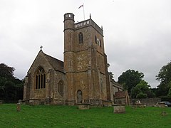
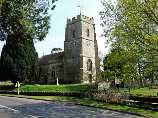
St Michael and All Angels’ Church is a Grade II* listed parish church in the Church of England in East Coker, Somerset.

References

  1. 1 2 "Statistics for Wards, LSOAs and Parishes – SUMMARY Profiles" (Excel). Somerset Intelligence. Retrieved 4 January 2014.
  2. Gathercole, Clare. "An archaeological assessment of Yeovil" (PDF). English Heritage Extensive Urban Survey. Somerset County Council. p. 10. Archived from the original (PDF) on 25 October 2012. Retrieved 23 August 2011.
  3. "Text of the Somerset Domesday: Part 1', pp. 433–478". A History of the County of Somerset: Volume 1 (1906). British History Online. Retrieved 23 August 2011.
  4. "Somerset Hundreds". GENUKI. Retrieved 9 October 2011.
  5. "Manorial Society of England & Wales" . Retrieved 20 January 2023.
  6. "The civil war in Somerset". Somerset County Council. Archived from the original on 17 July 2011. Retrieved 23 August 2011.
  7. Sharrock, David (20 March 2011). "East Coker, TS Eliot's placid village, resists threat of housing invasion". The Guardian . Retrieved 23 August 2011.
  8. Chesshyre, Robert (22 October 2011). "Hands Off Our Land: the fight to protect TS Eliot's village". Telegraph. Retrieved 16 September 2017.
  9. Morris, Steven (22 August 2011). "TS Eliot village bids for world heritage status". The Guardian . Retrieved 23 August 2011. Poets, academics and residents have launched an attempt to win world heritage status for an English village beloved of TS Eliot that they say is threatened by developers. [...] The campaigners hope that heritage status could help block proposals to build 3,700 homes between the village and nearby Yeovil.
  10. "Yeovil RD". A vision of Britain Through Time. University of Portsmouth. Retrieved 4 January 2014.
  11. Historic England. "Coker Court (1057176)". National Heritage List for England . Retrieved 2 February 2008.
  12. Historic England. "Hymerford House (1057157)". National Heritage List for England . Retrieved 12 October 2008.
  13. Historic England. "Naish Priory (1057189)". National Heritage List for England . Retrieved 12 October 2008.
  14. "Nippy Bus Timetable" (PDF). Route N8 Timetable. Nippy Bus. Archived from the original (PDF) on 21 April 2016. Retrieved 15 March 2009.
  15. "Sureline Timetable". Routes 212 & X37 Timetable. Sureline. Retrieved 10 November 2010.
  16. "Nippy Bus How to Use Route N4". Route N4 How To. Nippy Bus. Archived from the original on 15 December 2008. Retrieved 15 March 2009.
  17. "Somerset EUS". www.somersetheritage.org.uk. Retrieved 4 September 2023.
  18. "Lease and Release 1. Henry Whitmarsh of Yeovil, Somerset, esq. 2. George Bullock of East Coker, Somerset, esq. 3. Samuel Hutchings of East Coker, sail cloth manufacturer. 4. William Lambert White of Yeovil, gentleman.Water Corn Mills, dwelling house, bakehouse, brewhouse and lands, Maiden Newton. Mentioned: Thos Hutchings; John Hopkins; Mary Garland; Wm Chipp; Robt Coombs; John Whittle; Wm Lovelace; Thos Hopkins; Mr Lilly; Richard Mowlam;". archive-catalogue.dorsetcouncil.gov.uk. Retrieved 4 September 2023.
  19. "Local History – East Coker Parish Council" . Retrieved 4 September 2023.
  20. Historic England. "Church of Saint Michael (1345781)". National Heritage List for England . Retrieved 2 February 2008.
  21. Dunning, Robert (1980). Somerset & Avon. Edinburgh: Bartholomew. p. 78. ISBN   0-7028-8380-8.
  22. Beazley, Charles Raymond (1911). "Dampier, William"  . Encyclopædia Britannica . Vol. 7 (11th ed.). pp. 790–791.
  23. Edward Chaney, Genius Friend: G.B. Edwards and The Book of Ebenezer Le Page, (Blue Ormer Publishing, 2015)
  24. "James Bree: Actor seen in 'On Her Majesty's Secret Service' and 'Dr Who'". The Independent. 6 March 2009. Retrieved 1 September 2011.
  25. "Village votes to halt sprawl". BBC. 8 December 2015. Retrieved 1 September 2011.
  26. Heybroek, H. M., Goudzwaard, L, Kaljee, H. (2009). Iep of olm, karakterboom van de Lage Landen (:Elm, a tree with character of the Low Countries). KNNV, Uitgeverij. ISBN   978-90-5011-281-9
  27. Collin, E., Bilger, I., Eriksson, G. & Turok, J. (2000). The conservation of elm genetic resources in Europe, in Dunn, C. P., (Ed.) (2000) The Elms: Breeding, Conservation and Disease Management. Kluwer Academic Publishers, Boston, USA.