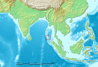
The Nicobar Islands are an archipelagic island chain in the eastern Indian Ocean. They are located in Southeast Asia, 150 km north of Aceh on Sumatra, and separated from Thailand to the east by the Andaman Sea. Located 1,300 km southeast of the Indian subcontinent, across the Bay of Bengal, they form part of the Union Territory of Andaman and Nicobar Islands, India.

Car Nicobar is the northernmost of the Nicobar Islands. It is also one of three local administrative divisions of the Indian district of Nicobar, part of the Indian union territory of Andaman and Nicobar Islands.
Little Andaman Island is the fourth largest of the Andaman Islands of India with an area of 707 km², lying at the southern end of the archipelago. It belongs to the South Andaman administrative district, part of the Indian union territory of Andaman and Nicobar Islands. the island is lying 88 km (55 mi) south from Port Blair, the capital of Andaman and Nicobar Islands and the nearest airport from where regular flights to Kolkata and Chennai are available.
Nicobar district is one of three districts in the Indian union territory of Andaman and Nicobar Islands. The district's administrative territory encompasses all of the Nicobar Islands, which are located in the Indian Ocean, between the Bay of Bengal and the Andaman Sea. The headquarters of the district is the village of Malacca, located on the island of Car Nicobar.
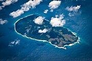
Narcondam is a small volcanic island located in the Andaman Sea. The island's peak rises to 710 m above mean sea level, and it is formed of andesite. It is part of the Andaman Islands, the main body of which lie approximately 124 km (77 mi) to the west. The island is part of the Indian union territory of Andaman and Nicobar Islands. The island is small, covering an area of approximately 6.8 square kilometres. It was classified as a dormant volcano by the Geological Survey of India.
Teressa is one of the Nicobar Islands, India.
Interview Island is an island of the Andaman Islands. It belongs to the North and Middle Andaman administrative district, part of the Indian union territory of Andaman and Nicobar Islands. the island is lying 125 km (78 mi) north from Port Blair.
Strait Island is an island of the Andaman Islands. It belongs to the North and Middle Andaman administrative district, part of the Indian union territory of Andaman and Nicobar Islands. The island lies 63 km (39 mi) north from Port Blair.
Tillangchong, also known as Tillanchang, is an island and a village in the Nicobar district of Andaman and Nicobar Islands, India.
Pulomilo is an island in the Nicobar district of Andaman and Nicobar Islands, India, and home to a village of the same name. It is located just north of Little Nicobar Island,
Champin is a village in the Nicobar district of Andaman and Nicobar Islands, India. It is located on the Nancowry Island, around 10 km from the Tapong village, and comes under the administration of the Nancowry tehsil.
Chowra is an island in the Andaman and Nicobar islands group of India. It is located to the north of Teressa island and to the south of Battimalv Island in the India Ocean. It is also known as Choura, Tatat or Sanenyo.
Battimalv is an island of the Nicobar Islands. It is part of the Indian union territory of Andaman and Nicobar Islands.
Paira is an island in the Nicobar district of Andaman and Nicobar Islands, India.
Man is an uninhabited island in the Nicobar district of Andaman and Nicobar Islands, India.
Nancowry Subdivision is one of three local administrative divisions of the Indian district of Nicobar, part of the Indian union territory of Andaman and Nicobar Islands.
Stewart Island is an island of the Andaman Islands. It belongs to the North and Middle Andaman administrative district, part of the Indian union territory of Andaman and Nicobar Islands. the island is lying 150 km (93 mi) north from Port Blair.
Aves Island is an island of the Andaman Islands. It belongs to the North and Middle Andaman administrative district, part of the Indian union territory of Andaman and Nicobar Islands. The island lies 140 km (87 mi) north from Port Blair.
North Passage Island is an island of the Andaman Islands. It belongs to the North and Middle Andaman administrative district, part of the Indian union territory of Andaman and Nicobar Islands. The island lies 80 km (50 mi) north from Port Blair.