
The Great Western Highway is a 201-kilometre-long (125 mi) state highway in New South Wales, Australia. From east to west, the highway links Sydney with Bathurst, on the state's Central Tablelands.

Lithgow is a town in the Central Tablelands of New South Wales, Australia and is the administrative center of the City of Lithgow local government area. It is located in a mountain valley named Lithgow's Valley by John Oxley in honour of William Lithgow, the first Auditor-General of New South Wales.

Glenbrook is a township of the Lower Blue Mountains of New South Wales, Australia. It is located 63 kilometres west of Sydney in the local government area of the City of Blue Mountains. At the 2016 Australian census Glenbrook had a population of 5,051 people.

The City of Blue Mountains is a local government area of New South Wales, Australia, governed by the Blue Mountains City Council. The city is located in the Blue Mountains range west of Sydney.

Mount Victoria is a small township in the Blue Mountains of New South Wales, Australia. It is the westernmost village in the City of Blue Mountains, located about 120 kilometres (75 mi) by road from the Sydney central business district and at an altitude of about 1,052 metres (3,451 ft) AHD . The settlement had a population of 823 people at the 2011 Census.

Hartley is a historical village in the Central Tablelands region of New South Wales, Australia, within the City of Lithgow local government area, located approximately 127 kilometres (79 mi) west of the Sydney central business district. Hartley is located below the western escarpment of the Blue Mountains.

The Lapstone Zig Zag was a zig zag railway built between Emu Plains and Blaxland stations on the Main Western line of New South Wales in Australia. Constructed between 1863 and 1865 to overcome an otherwise insurmountable climb up the eastern side of the Blue Mountains, the zig zag and associated Knapsack Viaduct, a sandstone arch viaduct, were designed by John Whitton, Engineer-in-Charge of New South Wales Government Railways, and were built by William Watkins. The zig zag was listed on the Blue Mountains local government heritage register on 27 December 1991; while the adjacent Knapsack Viaduct was listed on the New South Wales Heritage Database on 2 April 1999. The Lapstone ZigZag was the world-first ZigZag constructed on any main-line railway.

The City of Lithgow is a local government area in the Central West region of New South Wales, Australia. The area is located adjacent to the Great Western Highway and the Main Western railway line.
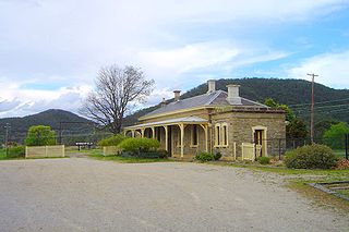
The Bowenfels railway station is a heritage-listed disused railway station and now visitor's centre and restaurant located on the Main Western line in Bowenfels, City of Lithgow, New South Wales, Australia. It was designed by John Clifton and the New South Wales Government Railways and built from 1869 to 1869 by G. Watsford, NSW Government Railway. It is also known as the Bowenfels Railway Station and Stationmaster's House and Old Station Masters Residence and Station. It was added to the New South Wales State Heritage Register on 2 April 1999.
Rydal is a small rural village in New South Wales, Australia.
O’Connell is a village in New South Wales, Australia. The village, classified by the National Trust of Australia, is 23 kilometres from Oberon on the O'Connell Road. At the 2006 census, O'Connell and the surrounding area had a population of 355.

The Lithgow Zig Zag is a heritage-listed former zig zag railway line built near Lithgow on the Great Western Line of New South Wales in Australia. The zig zag line operated between 1869 and 1910, to overcome an otherwise insurmountable climb and descent on the western side of the Blue Mountains. It was designed by John Whitton and built from 1863 to 1869 by Patrick Higgins as contractor. It is also known as the Great Zig Zag Railway and Reserves and Zig Zag Railway. The property is owned by Department of Planning and Infrastructure. It was added to the New South Wales State Heritage Register on 2 April 1999.

Wallerawang is a small township in the Central Tablelands of New South Wales, Australia. It is located approximately 14 kilometres (8.7 mi) northwest of Lithgow adjacent to the Great Western Highway. It is also located on the Main Western railway line at the junction of the Gwabegar line.

The Lithgow Underbridge is a heritage-listed railway underbridge that carries the Main West Line over James Street, in Lithgow, in the City of Lithgow local government area of New South Wales, Australia. The bridge is located approximately 156 kilometres (97 mi) from Central railway station. The bridge was designed by John Whitton as the Engineer-in-Chief for Railways and was built in 1869 by contractor, P. Higgins. It is also known as Lithgow Underbridge. The property is owned by RailCorp, an agency of the Government of New South Wales. It was added to the New South Wales State Heritage Register on 30 August 2013.

The Lithgow Heavy Anti Aircraft Gun Stations and Dummy Station is a heritage-listed former gun emplacements, anti aircraft gun batteries and dummy batteries and now disused railway signal box located via Kirkley Street, Bowenfels, City of Lithgow, New South Wales, Australia. It was built from 1941 to 1942 by Water Conservation & Irrigation Commission, Defence. It is also known as Lithgow Anti Aircraft Gun Emplacements and Heavy Anti Aircraft guns 3.7 inch anti aircraft guns. The property is owned by Lithgow City Council. It was added to the New South Wales State Heritage Register on 5 August 2011.

The Marrangaroo railway viaduct is a heritage-listed railway viaduct that carries the Main Western line across Marrangaroo Creek at Marrangaroo in the City of Lithgow local government area of New South Wales, Australia. The property added to the New South Wales State Heritage Register on 2 April 1999.

The Bowenfels rail viaducts are a series of heritage-listed railway viaducts and railway bridges over Farmers Creek on the Main Western line in Bowenfels, City of Lithgow, New South Wales, Australia. It was designed in two stages, by John Whitton as the Engineer-in-Chief for Railways, in 1870; and by engineering staff of New South Wales Government Railways in 1921; and was built from 1870 to 1921. It is also known as Farmers Creek viaducts. The property is owned by RailCorp, an agency of the Government of New South Wales. It was added to the New South Wales State Heritage Register on 2 April 1999. The viaduct are located approximately 159 kilometres (99 mi) west of Central railway station.

Fernhill is a heritage-listed former house and former inn located beside the Great Western Highway in Bowenfels, City of Lithgow, New South Wales, Australia. It was built from 1856 to 1859 by John Blackman. It is also known as Australia Arms Inn. The property is owned by National Trust of Australia (NSW). It was added to the New South Wales State Heritage Register on 2 April 1999. On 18 July 2019 it was sold as a residential property.

The Coxs River railway bridges are two heritage-listed railway bridges that carry the Main Western line over the Coxs River at Wallerawang, City of Lithgow, New South Wales, Australia. The bridges were designed by engineering staff of the New South Wales Government Railways and built in 1870 by day labour. The property is owned by RailCorp, an agency of the Government of New South Wales. It was added to the New South Wales State Heritage Register on 2 April 1999.

The Rydal rail underbridges are a series of heritage-listed railway underbridges and viaducts that carry the Main Western line over Solitary Creek at Rydal, in the City of Lithgow local government area of New South Wales, Australia. The property is owned by RailCorp, an agency of the Government of New South Wales. It was added to the New South Wales State Heritage Register on 2 April 1999.

