Bruncu Spina

Last updated
Bruncu Spina
La cima del Bruncu Spina - 1829 m s.l.m. - Sardegna.JPG
Highest point
Elevation 1,829 m (6,001 ft)
Prominence 178 m (584 ft)
Isolation 366 km (227 mi)
Coordinates 40°00′57″N9°18′14″E / 40.015754°N 9.303969°E / 40.015754; 9.303969
Geography
Italy relief location map.jpg
Red triangle with thick white border.svg
Bruncu Spina
Country Flag of Italy.svg Italy
Parent range Gennargentu

Bruncu Spina, with its 1,829 meters is the second highest peak in Sardinia after Punta La Marmora. [1] It is located in the Gennargentu massif, in the province of Nuoro, in the administrative territory of the municipalities of Villagrande Strisaili and Desulo. The territorial portion in the head of the municipality of Villagrande Strisaili was granted in perpetual emphyteusis to the municipality of Fonni. [2]

Contents

On the top of the mountain there was an astronomical observatory, currently reduced to the state of ruins. [3]

Description

Origin and meaning of the name

The toponym in Sardinian can be translated as "summit of the thistle." This name can be attributed to the presence on the mountain of herbaceous species belonging to the Asteraceae family. According to others (Massimo Pittau - Toponyms of Southern Sardinia) the toponym means "summit of the thorn" and refers to the Prunus prostrata that grows there. [4]

Climate

Precipitation is concentrated in the autumn, winter and spring months. [5] Frequent snowfall occurs during the winter season, with more than two meters of snowfall each year and snowfields of several meters accumulating in some places due to winds (snowfields last until May/June). January and February are the months when the heaviest snowfall occurs, with heavy snowfall also occurring in March (01/03/2016, 70 cm of snow) and April. [6]

Flora and fauna

From a floristic-vegetational point of view, the mountain slopes are covered with low scrubland formations that are the result of the processes of degradation of the original vegetation due to overgrazing and the indiscriminate use of fire as a means of obtaining new areas useful for livestock farming. [7] Holm oak (Quercus ilex) woodland formations can be found at altitudes below 1,400 meters while downy oak (Quercus pubescens) is found in small, sparse, isolated groups in association with cade juniper (Juniperus oxycedrus). At higher altitudes, shrub species that assume a creeping habit due to the unfavorable climatic conditions are found. The most commonly represented species are tree heath (Erica arborea), Corsican broom ( Genista corsica ), dwarf juniper (Juniperus nana), caraway thyme (Thymus herba-barona), and greater barberry (Santolina insularis). In the valleys, stream banks are characterized by gallery forests formed by black alder (Alnus glutinosa). [5] The presence of the rare Lamyropsis microcephala , a species endemic to Sardinia, is also noted. It grows on the slopes of Bruncu Spina, in an estimated range of about 100 m2. [8]

The fauna is represented by birds such as the golden eagle (Aquila chrysaetos), Bonelli's eagle (Hieraaetus fasciatus), red kite (Milvus milvus) and griffon vulture (Gyps fulvus). Mammals, on the other hand, are represented by wild boar (Sus scrofa), fox (Vulpes vulpes ichnusae), marten (Martes martes) and Sardinian wildcat (Felis lybica sarda). [9]

Ski

Skiing is possible on the slopes of the mountain. Along the side of Fonni (Separadorgiu) there is a ski lift, while on the side of Desulo (s'Arena) there is a 300-meter long moving walkway. The ski season normally lasts 2–3 months (December to March) and attracts several thousand people. [10]

Hiking

The summit of Bruncu Spina can be reached by following several hiking trails, maintained by the Forestry Authority of Sardinia. Along the way there are several viewpoints and areas with facilities for resting. The paths through which the summit can be reached are:

See also

Related Research Articles

<span class="mw-page-title-main">Sardinian language</span> Romance language indigenous to the island of Sardinia

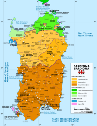
Sardinian or Sard is a Romance language spoken by the Sardinians on the Western Mediterranean island of Sardinia.

<span class="mw-page-title-main">Sardinia</span> Island in the Mediterranean and region of Italy

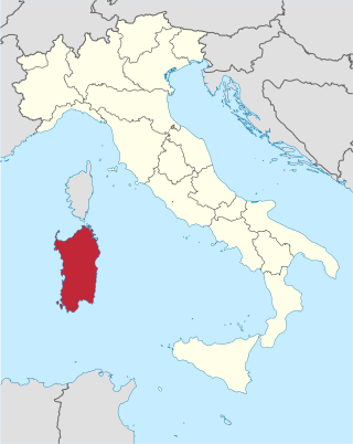
Sardinia is the second-largest island in the Mediterranean Sea, after Sicily, and one of the 20 regions of Italy. It is located west of the Italian Peninsula, north of Tunisia and immediately south of the French island of Corsica.

<span class="mw-page-title-main">Cagliari</span> Comune in Sardinia, Italy

Cagliari is an Italian municipality and the capital of the island of Sardinia, an autonomous region of Italy. Cagliari's Sardinian name Casteddu means castle. It has about 155,000 inhabitants, while its metropolitan city has about 420,000 inhabitants. According to Eurostat, the population of the Functional urban area, the commuting zone of Cagliari, rises to 476,975. Cagliari is the 26th largest city in Italy and the largest city on the island of Sardinia.

<span class="mw-page-title-main">Gennargentu</span> Mountain in Italy

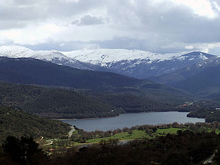
Gennargentu is a large massif in central-southern Sardinia, Italy, encompassing the provinces of Nuoro and Ogliastra. It includes the highest peaks on the island, such as Punta La Marmora, Monte Spada, Punta Erbas Virdes, Bruncu Spina and Punta Paulinu.

<span class="mw-page-title-main">Whiteface Mountain</span> Mountain in New York

Whiteface Mountain is the fifth-highest mountain in the state of New York, USA, and one of the High Peaks of the Adirondack Mountains. Set apart from most of the other High Peaks, the summit offers a 360-degree view of the Adirondacks and clear-day glimpses of Vermont and even Canada, where the skyscrapers of Montreal, 80 miles (130 km) away, can be seen on a very clear day. Located in the town of Wilmington, about 13 miles (21 km) from Lake Placid, the mountain's east slope is home to a major ski area with the greatest vertical drop east of the Rockies, which hosted the alpine skiing competitions of the 1980 Winter Olympics. Unique among the High Peaks, Whiteface features a developed summit and seasonal accessibility by motor vehicle. Whiteface Memorial Highway reaches a parking area at an elevation of 4,600 feet (1,400 m), with the remaining 267 feet (81 m) being obtained by tunnel and elevator.

<span class="mw-page-title-main">National Park of the Gulf of Orosei and Gennargentu</span> National park in Sardinia

The Gennargentu National Park is a national park on the east coast of Sardinia.

<span class="mw-page-title-main">Nuragic civilization</span> Archaeological culture in Sardinia

The Nuragic civilization, also known as the Nuragic culture, was a civilization or culture on the Mediterranean island of Sardinia, Italy, which lasted from the 18th century BC up to the Roman colonization in 238 BC. Others date the culture as lasting at least until the 2nd century AD and in some areas, namely the Barbagia, to the 6th century AD or possibly even to the 11th century AD.

<span class="mw-page-title-main">Sardinian people</span> Romance ethnic group native to Sardinia

The Sardinians, or Sards, are a Romance language-speaking ethnic group native to Sardinia, from which the western Mediterranean island and autonomous region of Italy derives its name.

<span class="mw-page-title-main">Paleo-Sardinian language</span> Extinct language isolate indigenous to the island of Sardinia

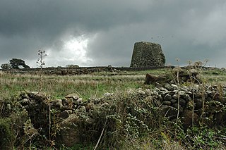
Paleo-Sardinian, also known as Proto-Sardinian or Nuragic, is an extinct language, or perhaps set of languages, spoken on the Mediterranean island of Sardinia by the ancient Sardinian population during the Nuragic era. Starting from the Roman conquest with the establishment of a specific province, a process of language shift took place, wherein Latin came slowly to be the only language spoken by the islanders. Paleo-Sardinian is thought to have left traces in the island's onomastics as well as toponyms, which appear to preserve grammatical suffixes, and a number of words in the modern Sardinian language.

<span class="mw-page-title-main">Tourism in Sardinia</span> Place

Sardinia is the second largest island in the Mediterranean Sea and an autonomous region of Italy. Tourism in Sardinia is one of the fastest growing sectors of the regional economy. The island attracts more than a million tourists from both Italy, from the rest of Europe, and, to a lesser degree, from the rest of the world. According to statistics, tourist arrivals in 2016 were 2.9 million people.

<span class="mw-page-title-main">Giants of Mont'e Prama</span> Ancient sculptures in Sardinia (Italy)

The Giants of Mont'e Prama are ancient stone sculptures created by the Nuragic civilization of Sardinia, Italy. Fragmented into numerous pieces, they were discovered in March 1974 on farmland near Mont'e Prama, in the comune of Cabras, province of Oristano, in central-western Sardinia. The statues are carved in local sandstone and their height varies between 2 and 2.5 meters.

This article presents a history of Cagliari, an Italian municipality and the capital city of the island of Sardinia. The city has been continuously inhabited since at least the neo-lithic period. Due to its strategic location in the Mediterranean and natural harbor, the city was prized and highly sought after by a number of Mediterranean empires and cultures.

<span class="mw-page-title-main">Mount Arcuentu</span> Mountain in Italy

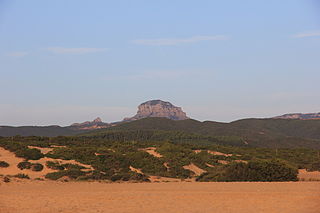
Mount Arcuentu, elevation 785 m (2,575 ft), is a volcanic massif situated in southwestern Sardinia, northwest of Arbus. It is a summit of a mountain range which runs parallel to the coastline of Costa Verde for about 8 kilometres (5.0 mi).

<span class="mw-page-title-main">Sardinian surnames</span>

Sardinian surnames are surnames with origins from the Sardinian language or a long, identifiable tradition on the Western Mediterranean island of Sardinia.

<span class="mw-page-title-main">Mount Warren (California)</span> Mountain of Mono County, California

Mount Warren is a 12,327-foot-elevation (3,757 meter) summit located in the Sierra Nevada mountain range, in Mono County, California, United States. The mountain is set within the Hoover Wilderness, on land managed by Inyo National Forest. The peak is situated 1.5 miles (2.4 km) south of Gilcrest Peak, 1.8 miles (2.9 km) northwest of Lee Vining Peak, and 5 miles (8.0 km) southeast of Excelsior Mountain, which is the nearest higher neighbor. Topographic relief is significant as the summit rises 5,955 feet above Mono Lake in 4.5 miles.

<span class="mw-page-title-main">Mount Lincoln (California)</span> Mountain in the state of California

Mount Lincoln is an 8,383-foot-elevation (2,555 meter) mountain summit in Placer County, California, United States.

<span class="mw-page-title-main">Mount Judah</span> Mountain in the state of California

Mount Judah is an 8,243-foot-elevation (2,512 meter) mountain summit in Placer County, California, United States.

<span class="mw-page-title-main">Twin Peaks (Placer County, California)</span> Double summit mountain in the state of California

Twin Peaks is an 8,878-foot-elevation (2,706 meter) double summit mountain in Placer County, California, United States.

<span class="mw-page-title-main">Bruncu Spina ski area</span> Ski resort in Sicily, Italy

The ski area Bruncu Spina is the only ski area in Sardinia. The systems are installed on the slopes of Bruncu Spina and of Monte Spada. It is located in the Gennargentu massif, in the administrative territory of the municipalities of Fonni, Desulo and Villagrande Strisaili, in province of Nuoro.

<span class="mw-page-title-main">Monte Gonare</span> Mountain in Sardinia, Italy

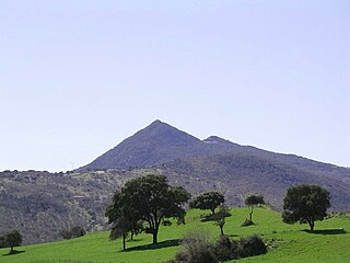
Mount Gonare is a mountain formation in central Sardinia, in the province of Nuoro. It is located in the administrative territory of Orani and Sarule and rises to an elevation of 1,083 m above sea level.

References

  1. Ignazio Camarda (1988), p.269.
  2. "Monte Novu". Archived from the original on December 11, 2010. Retrieved 16 October 2010.
  3. Heck, André (2004). "Italy". StarGuides Plus: a world-wide directory of organizations in astronomy and related space sciences. Dordrecht: Kluwer Academic Publishers. p. 327. ISBN   9781402019265 . Retrieved 29 October 2010.
  4. "Massimo Pittau - Toponimi della Sardegna meridionale". www.pittau.it. Retrieved 2023-06-27.
  5. 1 2 "Monte Novu sul sito SardegnaForeste" . Retrieved 29 October 2010.
  6. Chessa, Piero Angelo; Alessandro Delitala (1997). "7. La neve". Il clima della Sardegna. Sassari: Chiarella. pp. 17–20. Retrieved 18 October 2010.
  7. Ignazio Camarda (1993), p.280.
  8. "Lamyropsis microcephala". Top 50 Campaign Mediterranean Island Plants. International Union for Conservation of Nature and Natural Resources. Archived from the original on 15 April 2013. Retrieved 28 February 2021.
  9. "Massiccio del Gennargentu" . Retrieved 29 October 2010.
  10. "Dove sciare a Bruncu Spina". Sci Marche (in Italian). 2019-12-19. Retrieved 2023-06-27.
  11. "Sentiero Gennargentu T-721" . Retrieved 29 October 2010.
  12. "Sentiero Arcu Artilai - Bruncu Spina T-721A" . Retrieved 29 October 2010.

Bibliography