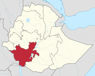
The Southern Nations, Nationalities, and Peoples' Region was a regional state in southwestern Ethiopia. It was formed from the merger of five kililoch, called Regions 7 to 11, following the regional council elections on 21 June 1992. Its government was based in Hawassa.

Arba Minch is a city and separate woreda in the southern part of Ethiopia. "Arba Minch" means "40 Springs", originated from the presence of more than 40 springs. It is located in the Gamo Zone of the South Ethiopia Regional State, about 500 kilometers south of Addis Ababa, at an elevation of 1285 meters above sea level. It is the largest town in Gamo Zone. It is surrounded by Arba Minch Zuria woreda. This Town has plenty of natural gifts including the bridge of God, Crocodile ranch, crocodile market, different fruits and vegetables, different fishes farmed from Chamo and Abaya Lakes, more than 40 springs, different cereals, and crops, surprisingly having the two big Lakes in the country, lake Abaya and Chamo, respectively, next to Lake Tana, etc. This makes the town one of the tourist destinations in Ethiopia, which comprises Nech Sar National Park, home to the country's varied wildlife and plant species.

Asella is a town in central Ethiopia. Located in the Arsi Zone of the Oromia Region 126 km (78 mi) south from Addis Ababa, this town has a latitude and longitude of 7°57′N39°7′E, with an elevation of 2,430 meters. Asella hosts an Asella Airport. Asalla was the capital of Arsi Province until that province was demoted to a Zone of Oromia with the adoption of the 1995 Constitution. It retains some administrative functions as the seat of the present Arsi Zone.

Chencha is a town in southern Ethiopia. Located in the Gamo Gofa Zone of the Southern Nations, Nationalities, and Peoples Region, 37 kilometers north of Arba Minch, Chencha has a longitude and latitude of 6°15′N37°34′E and an elevation of 2732 meters above sea level.
Maji is a town in south western Ethiopia. It is located on the Boma Plateau, lying in the West Omo Zone of the South West Ethiopia Peoples' Region, and has a longitude and latitude of 6°12′N35°35′E with an elevation variously given as 2,104, 2,258 and 2,430 meters above sea level. The town is the administrative center for the Maji woreda.
Kurmuk is a town in western Ethiopia. Located in the Asosa Zone of the Benishangul-Gumuz Region, Kurmuk has a latitude and longitude of 10.557192°N 34.295485°E with an elevation of 653 meters above sea level.
Adami Tullu a town located about 168 kilometers south of Addis Ababa in the East Shewa Zone of the Oromia Region, Ethiopia., Adami Tullu has a latitude and longitude of 7°52′N38°42′E with an elevation of 1636 meters above sea level. It is one of five towns in Adami Tullu and Jido Kombolcha woreda.

Omorate is a town in southern Ethiopia near the Kenyan border. Located in the Debub Omo Zone of the Southern Nations, Nationalities and Peoples' Region, this village has a latitude and longitude of 4°48′N35°58′E with an elevation of 395 meters above sea level. It is the administrative center of Kuraz woreda.
Melokoza is one of the woredas in the Southern Nations, Nationalities, and Peoples' Region of Ethiopia. Part of the Gamo Gofa Zone, Melokoza is bordered on the south by Basketo special woreda, on the southwest by the Debub (South) Omo Zone, on the northwest by the Konta special woreda, on the north by the Dawro Zone, and on the east by Demba Gofa and Geze Gofa; the Omo River defines its northwestern boundary separating the woreda from Konta and the Dawro Zone. The major town in Melokoza is Leha.
Sendafa is a town and separate woreda in Oromia Region, Ethiopia. Its name is taken from the Oromo name for a kind of thick, jointed grass or reed which grows in swampy areas. Located in the Oromia Special Zone Surrounding Finfinne of the Oromia Region, Sendafa has a latitude and longitude of 9°09′N39°02′E with an elevation of 2514 meters above sea level. The town lies on the paved Addis Ababa - Adigrat highway, some 38 kilometers north of the capital.

Debarq also spelled Dabareq and Debark, is a town in northern Ethiopia, 90 kilometers north-east of Gondar on the highway between Gondar and Axum, and is in the Semien Gondar Zone of the Amhara Region. It has a latitude and longitude of 13°08′N37°54′E and an elevation of 2850 meters above sea level.
Mekane Selam is a town in central Ethiopia. Located in the South Wollo Zone of the Amhara Region, this town has a latitude and longitude of 10°45′N38°45′E with an elevation of 1827 meters above sea level. It is the administrative center of Borena woreda. The city is bordered by Eastern Gojjam in the west, Kelala and Wogide in the south, Leganbo (Akesta) in the east and Sayint (Agibar) in the north.
Bedele is a town and separate Aanaa in south-western Ethiopia. Located in the Buno Bedele Zone of the Oromia Region, this town has a longitude and latitude of 8°27′N36°21′E and an elevation between 2,012–2,162 metres (6,601–7,093 ft) above sea level.
Sawla is a town in southern Ethiopia. Located in Gofa Zone of the Southern Nations, Nationalities and Peoples' Region, this town has a latitude and longitude of 6°18′N36°53′E with an elevation of 1,395 metres (4,577 ft) above sea level. It is surrounded by Demba Gofa woreda.
Adola is a town located in the Guji Zone of the Oromia Region, at an altitude of 1,758 metres (5,768 ft) above sea level. 470 km from Addis Ababa.

Badessa is a town and separate Aanaa in eastern Ethiopia. Located in the West Hararghe Zone of the Oromia Region, at the base of a spur of the Chercher Mountains 40 km south of the Addis Ababa - Djibouti Railway and 65 km east of Awash, this town has a latitude and longitude of 8°54′N40°47′E with an elevation of 1761 m above sea level.
Mieso is a town in eastern Ethiopia. Located in the West Hararghe Zone of the Oromia Region, it has a latitude and longitude of 9°14′N40°45′E with an elevation of 1394 meters above sea level.

Gidole is a town in southern Ethiopia, and is the administrative center of the Dirashe special woreda. Located in the Southern Nations, Nationalities, and Peoples Region, it sits at a latitude and longitude of 05°39′N37°22′E with an elevation ranging from 2045 to 2650 meters above sea level. The town Gidole is named after the Kitoola people with a little bit modification, an ethnic group inhabiting southern Ethiopia.
Fofa is a town in southern Ethiopia, and is the administrative center of the Yem special woreda. Located in the Southern Nations, Nationalities, and Peoples Region, this town has a latitude and longitude of 07°51′N37°31′E with an elevation of 2506 meters above sea level.
በጎፋ ዞን የገዜ ጎፋ ወረዳ አስተዳደር gofa zone geze gofa woreda administration website


