Amaro Zone (Kore) is a zone in South west Ethiopia Regional State of Ethiopia. The people are called Kore and their language is Korigna. Amaro kore people are the descendants of the Christian missioners of north Ethiopian sematic peoples of Gonder, who were moved gradually through northern shewa (menze) to central and south western Ethiopian lands of Damot (wolayta), Dawuro, Gamo Gofa and surrounding areas of the region With their Christian traditions and heritages around eleventh; twelfth and thirteenth century. As the native of kore nation theologian Jebdu kassahun evidentially assured and narrated, That was a time of ST. Abune Gebremenfes kidus, st.tekle Haymanot, and emperor Yikuno Amlak, who were preached and expanded Christianity to central and south western Ethiopian lands. Amaro is one of the areas in which members of Kore nations widely live in. Amaro Kore people got zonal status in August 2023 A.D upon the formation of the South west Ethiopia Regional State. In 2011 A.D, the Segen Area Peoples Zone was established, which includes Amaro woreda and the three former special woredas surrounding it.[1] Located in the Great Rift Valley, Amaro kore peoples land is bordered on the south by Burji Zone, on the southwest by Konso Zone, on the west by Dirashe Zone, on the northwest by Gamo Zone and Lake Chamo, and on the north by Lake Abaya and in east and northeast by Oromia Region. It is divided into 35 kebeles. The administrative center of the woreda is Kelle. Jijola woreda, Derba Menena woreda, and Kereda are other growing municipals of the zone.
The highest peak in the zone is Mount Dello (3600 meters), which is part of the Kore mountains, the highest in Jemjem plateau and the second from the region. Much of the western part of this zone lies inside the (Enee Shanka) Nechisar National Park. The major crops grown in Amaro are enset (Enset ventricosum), teff, maize, wheat, barley, navy beans, and coffee.[2] Amaro has 39 kilometers of all-weather roads and 16 kilometers of dry-weather roads, for an average road density of 36 kilometers per 1000 square kilometers.[3] The Central Statistical Agency (CSA) reported that 1,082 tons of coffee were produced in the year ending in 2005, based on inspection records from the Ethiopian Coffee and Tea authority. This represented 0.48% of the Southern Nations, Nationalities and Peoples' Region (SNNPR)'s output and 1.08% of Ethiopia's total output.[4]
This zone was selected as one of the three areas for Agri-Service Ethiopia to implement an Integrated Food Security Program. This Program operates in 10 of the woreda's kebeles, with the goal of improving agricultural practices, developing new rural water sources, and maintain and improve the existing local schools.[2]
Kore is well known and rich by yearly overflowing rivers. Bewaye, Sarmale (Segen), Duano, Kondilcho are some of them. with the time now, due to the number of the people are increasing in alarming rate and the societies facing many challenges that arise from mal-administration from so-called segen zone, peoples are demanding the demolition of the zone and strongly claiming the assurance of their own right to self-administration under the status of independent Amaro Kore zone.
Demographics
Based on the 2007 Census conducted by the Central Statistical Agency of Ethiopia (CSA), this zone has a total population of 149,231, of whom 75,202 are men and 74,029 women. With an area of 1,522.16 square kilometers, Amaro has a population density of 104.93; 8,633 or 5.78% are urban inhabitants. A total of 28,969 households were counted in this zone, which results in an average of 5.15 persons to a household, and 27,941 housing units. The largest ethnic group reported in Amaro was the Koore people (97.8%); all other ethnic groups made up 2.2% of the population. Koore language was spoken as a first language by 97.36% of the inhabitants, and 1.28% spoke Amharic; the remaining 1.36% spoke all other primary languages reported. 87.76% of the population said they were Protestants, 6.12% practiced Ethiopian Orthodox Christianity, 2.78% practiced traditional beliefs, 1.84% were Catholics, and 1.14% were Muslim.[5]
In the 1994 Census this zone had a population of 98,315 in 19,060 households, of whom 49,277 were men and 49,038 women; 3,059 or 3.11% of its population were urban dwellers. The two largest ethnic groups reported in Amaro were the Koore people (93.11%), and the Amhara (0.8%); all other ethnic groups made up 6.19% of the population. Koore language was spoken as a first language by 97.79% of the inhabitants, 0.82% spoke Oromigna, and 0.82% spoke Amharic; the remaining 0.57% spoke all other primary languages reported.[6] 51.63% of the population said they were Protestants, 35.46% practiced traditional religions, and 10.38% practiced Ethiopian Orthodox Christianity.[7] Concerning education, 22.76% of the population were considered literate; 10.54% of children aged 7–12 were in primary school; 1.32% of the children aged 13–14 were in junior secondary school, and 0.84% of the inhabitants aged 15–18 were in senior secondary school.[8] Concerning sanitary conditions, about 36% of the urban houses and 9% of all houses had access to safe drinking water at the time of the census; 60% of the urban and 10% of the total had toilet facilities.[9]
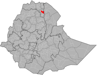
Yem Zone is one of the zones in the Central Ethiopia Regional State. Yem is named for the Yem, people whose homeland lies in this zone,. Yem is bordered on the west and north by the Oromia Region, and separated from Gurage on the northeast and Hadiya on the east by the Omo River. High points in Yem include Mount Bor Ama, Mount Azulu and Mount Toba. The administrative center of Yem is Saja.
Kembata is a zone in the Central Ethiopia Regional State of Ethiopia. It was formerly known as Kembata, Alaba and Tembaro, until Alaba and Tembaro became a special woreda in 2002 and 2023 respectively. This zone is named after the Kambaata people which gained zonal posture following the establishment of Central Ethiopian region in 2023.
Burji Zone is one of the zones in the South Ethiopia Regional State of Ethiopia. In August 2023 Burji special Woreda got zonal status upon the formation of South Ethiopia Region. In 2011, the Segen Area Peoples Zone was established, which includes Burji woreda and the 3 former special woredas surrounding it. It is named for the Burji people, who have their homeland in this zone. Burji is bordered on the east and south by the Oromia Region, on the west by the Konso Zone, and on the north by the Amaro Zone. The administrative center of Burji is Soyama.
Dirashe Zone is one of the zones in the South Ethiopia Regional State of Ethiopia. In 2011, the Segen Area Peoples Zone was established, which includes Dirashe woreda and the 3 former special woredas surrounding it. It is named for the Dirashe people, whose homelands lie in the eastern part of this woreda. Dirashe got zonal status when the South Ethiopia Regional State formed in August 2023.
Konso is a zone in the South Ethiopia Regional State, Ethiopia. It was formerly a woreda. Prior to 2011, Konso was not part of any Zone in the Southern Nations, Nationalities and Peoples' Region (SNNPR) and was therefore considered a special woreda, an administrative subdivision which is similar to an autonomous area. In 2011, the Segen Area Peoples Zone was established, which includes Konso special woreda and the 3 former woredas surrounding it. This special woreda is named after the Konso people. Located in the Great Rift Valley, Konso is bordered on the south by the Oromia Region, on the west by the South Omo Zone, on the northwest by Alle special woreda, on the north by Dirashe special woreda, on the northeast by Amaro special woreda, and on the east by Burji special woreda. The Sagan River, which flows south then west to join the Weito, defines part of the woreda's boundary with Burji and the entire length of the boundary with the Oromia Region. The administrative center is Karati; other towns in Konso include Fasha and Sagen. After protesting by residents to become a zone for several years, Konso became a zone in November 2018.
Tahtay Adiyabo is a woreda in the Tigray Region of Ethiopia. Part of the North Western Zone, Tahtay Adiyabo is bordered on the south by Asigede Tsimbela, on the southwest by the Tekezé River on the north by Eritrea, and on the east by La'ilay Adiyabo; part of the northern border with Eritrea is delineated by the Mareb River. The northernmost point of this woreda is the northernmost point of Ethiopia. Towns in this woreda include Addi Awuala and Addi Hageray. The town of Sheraro is surrounded by Tahtay Adiyabo.
Hintalo Wajirat is one of the Districts of Ethiopia or woredas in the Tigray Region of Ethiopia. It is named after its largest town, Hintalo, and the Wajirat Mountains in the southern part of the woreda. Located in the Debub Misraqawi (Southeastern) Zone at the eastern edge of the Ethiopian highlands Hintalo Wajirat is bordered on the south by the Debubawi (Southern) Zone, on the west by Samre, on the north by Enderta, and on the east by the Afar Region. Other towns in Hintalo Wajirat include Adi Gudem, and Bahri Tseba.
Kofele is one of the Districts in the Oromia Region of Ethiopia. It is named after the administrative center of the District, Kofele. Part of the West Arsi Zone, Kofele is bordered on the south by the Kokosa, on the west by the Southern Nations, Nationalities and Peoples' Region, on the northwest by the Shashamene(District), on the north by Kore, on the east by Gedeb Asasa, and on the south east by Dodola. Other towns in Kofele include Wabe Gefersa.
Damot Weyde is a woreda in South Ethiopia Regional State of Ethiopia. It is a Part of the Wolayita Zone located in the Great Rift Valley, Damot Weyde is bordered on the south by Hobicha, on the west by Sodo Zuria, on the northwest by Damot Gale, on the north and northeast by Diguna Fango wordas. The administrative center of the woreda is Bedessa.
Yeki is a woreda in South West Ethiopia Peoples' Region, Ethiopia. Part of the Sheka Zone, Yeki is bordered on the south by the Bench Maji Zone, on the west by the Gambela Region, on the north by Amderacha, and on the east by the Keffa Zone.The name 'Yeki' is named after the name of Sheko chief. The major town in Yeki is Tepi. Tepi is also named after the name of Majang man who live in the center of the current Tepi town.
Cheha is one of the woredas in the Southern Nations, Nationalities, and Peoples' Region of Ethiopia. This woreda is named after one of the sub-groups of the Sebat Bet Gurage, the Cheha. Part of the Gurage Zone, Cheha is bordered on the south by Enemorina Eaner, on the west by the Oromia Region, on the north by the Wabe River which separates it from Abeshge and Kebena, on the east by Ezha, and on the southeast by Gumer and Geta. The administrative center for Cheha is Endibir; other towns include Gubre.
Angacha is one of the woredas in the Southern Nations, Nationalities, and Peoples' Region of Ethiopia. Part of the Kembata Tembaro Zone, Angacha is bordered on the south by Kacha Bira, on the west by Doyogena, on the north by the Hadiya Zone, on the east by Damboya, and on the southeast by Kedida Gamela. Towns in Angacha include Angacha, the administration center and Funemura, a fast growing town in the northern part of Angacha woreda. Western part of Angacha woreda was separated to create Doyogena woreda including Amecho Wato town.
Shebedino is a woreda in Southern Nations, Nationalities, and Peoples' Region, Ethiopia. Part of the Sidama Zone located in the Great Rift Valley, Shebedino is bordered on the south by Dale, on the west by Boricha, on the north by Awasa Zuria, on the east by Gorche, and on the southeast by Wensho. Towns in Shebedino include Leku. Boricha and Gorche woredas were separated from Shebedino woreda.
Konta, previously called Ela, is a zone in the Southwest Region of Ethiopia. It is named after Konta people who speak the dialects called Kontatsuwa, Omotic languages. Before joining to Southwest Ethiopia Regional states, Konta was special woreda. This zone is bordered on the south by the Omo River which separates it from the Gamo Zone, Gofa Zone, and Selamgo woreda, Debub Omo Zone, on the west by the Keffa Zone, on the north by Oromia Region,Dedo and Mancho woreda, and on the east by the Dawro Zone; the Denchya River defines the southern part of the boundary with the Keficho Shekicho Zone. The administrative center is Ameya; other towns include Chida.
Kindo Koysha is a woreda in the South Ethiopia Regional State of Ethiopia. It is a Part of the Wolayita Zone, Kindo Koysha is bordered on the south by Offa, on the southwest by Kindo Didaye, on the west by the Dawro Zone, on the north by Boloso Bombe, on the west by Damot Sore, on the southwest by Kindo Didaye and on the southeast by Bayra Koysha. The administrative center of Kindo Koysha is Bale Hawassa. Kindo Didaye woreda was separated from Kindo Koysha.
Isara Tocha was one of the 77 woredas in the Southern Nations, Nationalities, and Peoples' Region of Ethiopia. Part of the Dawro Zone, Isara Tocha was bordered on the south by the Omo River which separates this woreda from the Gamo Gofa Zone, on the west by the Konta special woreda, on the north by the Gojeb River which separates it from the Oromia Region, on the east by Mareka Gena, and on the southeast by Loma Bosa. Towns in Isara Tocha included Bale and Tocha. Isara Tocha was separated to Isara and Tocha woredas.
Kucha is one of the woredas in the Part of the Gamo zone.The major town in Kucha is Selamber.
Kemba is one of the woredas in the Southern Nations, Nationalities, and Peoples' Region of Ethiopia. Part of the Gamo Gofa Zone, Kemba is bordered on the southwest by the Debub Omo Zone, on the west by Uba Debretsehay, on the northwest by Zala, on the northeast by Deramalo, on the east by Bonke, and on the southeast by the Dirashe special woreda; the Weito River defines the boundary with Bonke and Dirashe. The major town in this woreda is Kemba.
Melokoza is one of the woredas in the Southern Nations, Nationalities, and Peoples' Region of Ethiopia. Part of the Gamo Gofa Zone, Melokoza is bordered on the south by Basketo special woreda, on the southwest by the Debub (South) Omo Zone, on the northwest by the Konta special woreda, on the north by the Dawro Zone, and on the east by Demba Gofa and Geze Gofa; the Omo River defines its northwestern boundary separating the woreda from Konta and the Dawro Zone. The major town in Melokoza is Leha.
Adola is one of the woredas in the Oromia Region of Ethiopia. It is part of former Adolana Wadera woreda what was divided for Adola, Girja and Wadera woredas and Adola town. Part of the Guji Zone, Adolana Wadera was bordered on the south by Liben, on the southwest by Odo Shakiso, on the west by Bore, on the north by the Southern Nations, Nationalities, and Peoples Region, and on the east by the Bale Zone.
This page is based on this Wikipedia article Text is available under the CC BY-SA 4.0 license; additional terms may apply. Images, videos and audio are available under their respective licenses.