(''Oraș-reședință'')"},"subdivision_name3":{"wt":"[[File:Causeni Stema.jpg|25px]] [[Căușeni]]"},"leader_party":{"wt":""},"leader_title":{"wt":"Raion president"},"leader_name":{"wt":"Ciontoloi Ion ([[Democratic Party of Moldova|PLDM]]), since 2011"},"established_title":{"wt":""},"established_date":{"wt":"2002"},"area_total_km2":{"wt":"1163"},"area_land_km2":{"wt":""},"area_water_km2":{"wt":""},"area_water_percent":{"wt":""},"elevation_footnotes":{"wt":""},"elevation_m":{"wt":""},"population_as_of":{"wt":"[[2014 Moldovan Census|2014]]"},"population_footnotes":{"wt":"{{cite web | url= http://www.statistica.md/pageview.php?l=en&idc=479& | title= Results of Population and Housing Census in the Republic of Moldova in 2014 | publisher= [[National Bureau of Statistics of the Republic of Moldova]] | year=2017 | accessdate = 2017-05-01}}"},"population_total":{"wt":"81,185"},"population_density_km2":{"wt":"auto"},"population_note":{"wt":""},"timezone":{"wt":"[[Eastern European Time|EET]]"},"utc_offset":{"wt":"+2"},"timezone_DST":{"wt":"[[Eastern European Summer Time|EEST]]"},"utc_offset_DST":{"wt":"+3"},"area_code":{"wt":"[[Telephone numbers in Moldova|+373 43]]"},"blank_name":{"wt":"[[Vehicle registration plates of Moldova|Car plates]]"},"blank_info":{"wt":"CS"},"footnotes":{"wt":""},"website":{"wt":"{{url|http://www.causeni.md}}"}},"i":0}}]}" id="mwAg">District in Republic of Moldova
Căușeni District Raionul Căușeni | |
---|---|
District (Raion) | |
![]() | |
![]() | |
![]() | |
Country | ![]() |
Administrative center (Oraș-reședință) | ![]() |
Government | |
• Raion president | Ciontoloi Ion (PLDM), since 2011 |
Area | |
• Total | 1,163 km2 (449 sq mi) |
Population | |
• Total | 81,185 |
• Density | 70/km2 (180/sq mi) |
Time zone | UTC+2 (EET) |
• Summer (DST) | UTC+3 (EEST) |
Area code | +373 43 |
Car plates | CS |
Website | www |
Căușeni District (Romanian : Raionul Căușeni, pronunciation: [ k ə . u ˈ ʃ e nʲ ] ) is a district in the central part of Moldova, with the administrative center at Căușeni. The other major city in the district is Căinari. According to the 2014 Moldovan Census, the population of the district is 81,185.
The Căușeni District was the first district of Moldova to be recorded in 1455. The next localities of the region to be recorded were: Zaim, Cîrnățeni, Fîrlădeni, but not until the period 1535–1573. In the 16th-18th centuries, intensive agriculture and wine-making industries developed and population grew as a consequence. In 1761, in Căuşeni city, the Assumption Church was built with beautiful painted frescoes on the inside walls. In 1812, after the Russo-Turkish War (1806–1812), Bessarabia was occupied by the Russian Empire until 1917. During this period there was an intense Russification of the native population. In 1918, after the collapse of the Russian Empire, Bessarabia united with Romania. From 1918–1940 and again from 1941–1944 during the German occupation, the district became part of Tighina County. After the 1939 Molotov–Ribbentrop Pact, Bessarabia was occupied by the USSR in June 1940. In 1991 as a result of the proclamation of the Independence of Moldova, part of Căușeni District joined with Tighina County (1991–2003). In 2003 the district became an administrative unit of Moldova.
Căușeni District is located in the southern part of Moldova. It is bordered by the following districts: Ialoveni and Anenii Noi in the north, Slobozia District in the east, Ștefan Vodă District in the south-east, bordering in the south with Ukraine, and Cimișlia District in the west. The relief of the land is mostly flat, with maximum altitudes of 220–230 metres. The minimum altitude is 20–30 metres on the Lower Dniester plain. The land has a low intensity of erosion.
The district has a continental climate with an annual average district temperature of 11 °C (52 °F). The July average temperature is 23 °C (73 °F), and in January it is −4 °C (25 °F). Annual precipitation 450–550 mm. Average wind speed is 2–5 metres/second.
Typical European fauna, with the presence of such mammals such as foxes, hedgehogs, deer, wild boar, polecat, wild cat, ermine. and others. Of birds there are: partridges, crows, eagles, starlings, swallows, and more.
Forests of the district are composed of tree species such as oak, ash, hornbeam, linden, maple, walnut and others. Other common plants are: wormwood, knotweed, fescue, and nettle.
Căușeni district is located in the Dniester River basin, whose main tributary is the Botna River (152 km). Most lakes are artificial in origin.
As of 1 January 2012, the district population was 92,000, of which 26.5% was urban and 73.5% was rural population
Ethnic group | % of total |
---|---|
Moldovans * | 87.0 |
Romanians * | 5.4 |
Russians | 3.5 |
Ukrainians | 2.0 |
Bulgarians | 1.2 |
Gagauz | 0.7 |
Other | 0.2 |
Undeclared | 3.5 |
Footnote: * There is an ongoing controversy regarding the ethnic identification of Moldovans and Romanians.
The main economic activities of the district are agriculture and manufacturing. Currently there are 15,721 registered companies in the district. The different types of manufacturing that predominate are: wine-making, processing of milk, bakery products, and other industries based on local raw materials. Total Agricultural land is 93,700 ha which is (80.5%) of the total land area. Of this agricultural land, the arable land occupies 70 600 ha (60.7%), of which there are 4,300 ha of orchards (3.7%) and 5,200 ha of vineyards (4.5%).
The district operates 69 educational institutions, including institutions of secondary education - 37 (14,960 students), kindergartens - 31 (3014 children), a creative center for children.
Căușeni District has historically voted mainly for right-wing parties. In Moldova the district is represented by the Alliance for European Integration (AEI). The Party of Communists of the Republic of Moldova (PCRM) has seen a continuous fall in the percentage of the vote during the last three elections.
During the last three elections the vote for the AEI has grown from 11,179 votes to 20,140 votes representing an increase of 80%.
Year | AEI | PCRM |
---|---|---|
2010 | 51.58%20,140 | 41.19% 16,082 |
July 2009 | 50.27%19,629 | 44.26% 17,281 |
April 2009 | 30.03% 11,179 | 53.01%19,733 |
Parties and coalitions | Votes | % | +/− | |
---|---|---|---|---|
Party of Communists of the Republic of Moldova | 16,082 | 41.19 | −3.07 | |
Liberal Democratic Party of Moldova | 12,525 | 32.08 | +19.62 | |
Democratic Party of Moldova | 4,725 | 12,10 | +3.13 | |
Liberal Party | 2,515 | 6.44 | −5.68 | |
European Action Movement | 835 | 2.14 | +2.14 | |
United Moldova | 437 | 1.12 | +1.12 | |
Other Party | 1,538 | 3.91 | -18.34 | |
Total (turnout 57.46%) | 39,352 | 100.00 |
In the Căușeni District there are: 37 houses of culture, several folk bands with a Title 31 model, and 74 amateur artistic groups with a total of 1200 participants. There is a School of Arts in Căușeni city, a school of Music in both Căinari and Copanca, a museum of history and ethnography of Căușeni, the "Alexei Mateevici House Museum" in Zaim, and in Cainari, a Museum of history and ethnography in Copanca, and 45 public Libraries including 9 branches for children].
Health services are provided in Căușeni District through: a general fund hospital with 292 beds, 19 Magnetic field imaging (MFI) units, 13 health centres, 5 health points, and 13 clinical diagnostic laboratories.
Moldova is divided administratively into two levels:
The history of the Jews in Bessarabia, a historical region in Eastern Europe, dates back hundreds of years.
Slobozia District is a district of Transnistria. It is the southernmost district of Transnistria, located mostly south of Tiraspol. Its seat is the city of Slobozia, located at 46°44′N29°42′E, on the river Dniester. The district contains 4 cities/towns and 12 communes :
Cimișlia is a district in southern Moldova, situated between the capital of Chișinău and the autonomous territorial unit of Gagauzia, with its administrative center being the town of Cimișlia. On 1 January 2011, its population was officially recorded to be 61,700.
Dondușeni District is a district (raion) in the north of Moldova. Its administrative center is the city of Dondușeni. As of 2011, its population was 45,100.
Florești is a district in the north-east of Moldova, with the administrative center at Florești. The other major cities are Ghindeşti and Mărculeşti. As of 1 January 2011, its population was 90,000.
Leova District is a district in the central part of Moldova, bordering Romania, with the administrative center at Leova. As of 2014, its population was 44,702.
Șoldănești is a district in the north-east of Moldova, with the administrative center at Șoldănești. As of 2014, its population was 36,743.
Ștefan Vodă is a district in the south-east of Moldova, with the administrative center at Ștefan Vodă. As of 1 January 2011, its population was 71,900. The district is situated 100 km from Chișinău and 100 km from Odesa, Ukraine.
Anenii Noi District is a district (raion) in the central part of Moldova. As of 1 January 2011, its population was 83,100. Its seat is the city of Anenii Noi.
Basarabeasca is a district in the south of Moldova, with the administrative center at Basarabeasca.
Cantemir is a district in the south of Moldova, with the administrative center at Cantemir. As of January 1, 2011, its population was 62,800.
Ialoveni is a district in the central part of Moldova, with the administrative center at Ialoveni. As of 2014, its population was 93,154.
Orhei is a district in central Moldova, with its administrative center in the city of Orhei. As of 2014 Moldovan Census its population was 101,502.
The Transnistria Governorate was a Romanian-administered territory between the Dniester and Southern Bug, conquered by the Axis Powers from the Soviet Union during Operation Barbarossa. A Romanian civilian administration governed the territory from 19 August 1941 to 29 January 1944. A brief military administration followed, during which the Romanians withdrew from the region by late March 1944. German control became official on 1 April 1944.
Gîsca is a village near in Căușeni District, Moldova, composed of a single village with the same name, population 4,841 at the 2004 Census. The locality, although situated on the right (western) bank of the river Dniester, immediately to the south-west of the city of Tighina (Bender), in the Bessarabian, not Transnistrian part of Moldova, is under the control of the breakaway Transnistrian authorities.
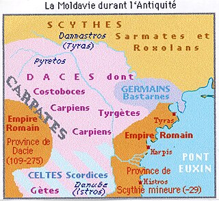
The Upper Trajan's Wall is the modern name given to a fortification located in the central area of modern Moldavia. Some scholars consider it to be of Roman origin, while others think it was built in the third/fourth century by the Germanic Greuthungi to defend their borders against the Huns. It may also have been called Greuthungian Wall in later Roman accounts, but this is uncertain owing to a single polysemic manuscript occurrence in the works of Ammianus Marcellinus.
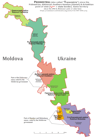
The Pridnestrovian Moldavian Republic is subdivided into five raions:
The Administrative-Territorial Units of the Left Bank of the Dniester (Transnistria) is a formal administrative unit of Moldova established by the Government of Moldova to delineate the territory controlled by the unrecognized Pridnestrovian Moldavian Republic.