Caldicot, Monmouthshire

Last updated

Caldicot
Caldicot Cross.jpg
Caldicot Cross in the town centre, a memorial to the deaths of local soldiers in World War I, World War II and other conflicts.
Monmouthshire UK location map.svg
Red pog.svg
Caldicot
Location within Monmouthshire
Population9,813 (2021 Census) [1]
OS grid reference ST475885
Principal area
Preserved county
Country Wales
Sovereign state United Kingdom
Post town CALDICOT
Postcode district NP26
Dialling code 01291
Police Gwent
Fire South Wales
Ambulance Welsh
UK Parliament
List of places
UK
Wales
Monmouthshire
51°35′28″N2°44′57″W / 51.5910°N 2.7492°W / 51.5910; -2.7492

Caldicot (Welsh : Cil-y-coed) is a market town and community in Monmouthshire, Wales. The town is located between Chepstow and the city of Newport. The site adjoins the Caldicot Levels, on the north side of the Severn Estuary. The population of the built-up area was around 11,000. It has a large school, Caldicot School, and is known for its medieval castle. The built-up area includes Portskewett. Caldicot had a population of 9,604 in 2011. [2]

Contents

History

There was considerable activity in the area during the Bronze Age. Excavations near the Nedern Brook beside the castle revealed a plank from a boat and complex wooden structures in the former river bed. The boat probably traded across the Severn with the farmers and traders of Somerset. Later, in Roman times, it is likely that trading vessels sailed up the Nedern Brook to Caerwent. The discovery of kilns also shows that coarse pottery was produced in the village during Roman times. [3]

In 1074, following the Norman Conquest, the manor of Caldicot was given to Durand, the Sheriff of Gloucester. Caldicot was recorded in Gloucestershire by the Domesday Book in 1086. Its entry reads, Durand the Sheriff holds of the King, one land, in Caerwent, called Caldicot. He has in demesne there 3 ploughs, and 15 half villeins, and 4 bondmen, and one knight. All these have twelve ploughs. There is a mill worth ten shillings.

The name 'Caldicot' is usually stated to derive from the Old English phrase calde cot meaning 'cold hut'. A cold hut is an exposed shelter used by either humans or animals. The modern Welsh name, Cil-y-coed, meaning "corner of the wood", referring to Wentwood, is an example of folk etymology. [4]

One of the oldest buildings in Caldicot, Llanthony Secunda Manor, was built around 1120 as a grange for monks from Llanthony Secunda Priory in Gloucester. [5]

In 1158 the manor of Caldicot passed to Humphrey II de Bohun, who was responsible for building the stone keep and curtain walls of the present-day castle. In 1376 it passed to Thomas Woodstock, third son of King Edward III, when he married Alianore de Bohun. It began to fall into ruins around the 16th century.

Caldicot is one of the few villages to appear on the Cambriae Typus map of 1573. [6]

By the mid-19th century, Caldicot was a small farming village. However, the opening of the South Wales Railway brought London and Cardiff within relatively easy reach (although Caldicot station itself was not opened until 1936). The railway attracted industry, and 1862 Henry Hughes of Tintern opened a wireworks next to the railway, becoming the village's major employer and attracting many new workers. In 1880 it became a tinplate works for the canning industry. In 1879 work began on the Severn Tunnel, which was opened in 1886. Its construction brought hundreds of workers to Caldicot, roughly doubling its population. [7] [8]

Court House was the home of baker Henry Jones, the inventor of self-raising flour, from 1864 until his death in 1891. He is buried in the churchyard. [9]

During the first half of the 20th century, Caldicot continued to grow steadily, but unspectacularly, reaching a population of 1,770 in 1951. Early in the 1950s, however, Chepstow Rural District Council decided that the village should be allowed to expand to approximately 3,000. Shortly after this decision, the government decided to build a new steelworks at Llanwern. Caldicot was designated as a suitable home for the thousands of steelworkers, and expansion plans were revised upwards. Llanwern steelworks opened in 1962, and by the end of the decade Caldicot had over 7,000 residents. [7]

The growth of the community was furthered by the opening of the Severn Bridge in 1966. With Caldicot now being part of the "M4 corridor" new businesses, such as telecommunication company Mitel, came to the town, compensating for the contraction of the steel industry and the railways. [7]

Religion

Parish church of St. Mary St. Mary's Church, Caldicot - geograph.org.uk - 95631.jpg
Parish church of St. Mary

The parish church of St. Mary, also called St Mary Virgin Church, [10] is a Church in Wales parish church. There is evidence that the church has pre-Norman foundations; however, the earliest part of the building dates from the 14th century. It is a Grade I listed building. It is mainly built in the Perpendicular style of the late 14th and 15th centuries.

Education

New building at Caldicot School, February 2017 New Build during construction .jpg
New building at Caldicot School, February 2017

Caldicot School was substantially rebuilt and the new buildings opened in September 2017. [11] [12] It will house all subject departments in one single building. The project was part of the Welsh Government's "21st Century Schools & Education Capital Programme". The new building has capacity for 1,500 pupils and was to cost £31million [13] which then rose to £34.9 million. By October 2016, the total cost was said to have risen to £40.175 million. [14]

Governance

Caldicot Town Council comprises seventeen elected or co-opted town councillors, from five community wards, namely Castle, Dewstow, Green Lane, Severn and West End. [15] Caldicot Castle, Dewstow, Green Lane, Severn and West End are also county wards to Monmouthshire County Council, each electing one county councillor. [16]

Attractions and amenities

The pedestrianised town centre of Caldicot on market day Caldicot.jpg
The pedestrianised town centre of Caldicot on market day

Caldicot is the location of Caldicot Castle and lake. The area has popular waymarked footpaths along the Caldicot Levels and the coastal path can be walked. Nearby are Caerwent and Wentwood. To the north-west, Dewstow House dates from c.1804. Extensive gardens and grottoes built after 1895 have been undergoing restoration since 2000 and are now open to the public.

Five primary schools are located in the area, two of which were created from local Infant and Junior Schools. Durand Primary (with nursery), Ysgol Gymraeg Y Ffin (Welsh-medium education provision for south Monmouthshire), Castle Park Primary (formed from Sandy Lane Infant School and St Mary's Juniors), Dewstow Primary (formally of West End Infants and Green Lane Juniors) and ARW (Archbishop Rowan Williams Church of Wales Primary School) in Portskewett. Caldicot is the nearest town to the Welsh side opening of the Severn railway tunnel, although the nearest station serving the line through the tunnel, Severn Tunnel Junction, is at Rogiet, a village which was developed in modern times largely to service the railway. Caldicot library was built in 1995. Caldicot Leisure Centre has a sports centre, one of four leisure centres in Monmouthshire. Its facilities include an indoor swimming pool, squash courts and both indoor and outdoor games pitches, and a gym. The Leisure Centre is located next to Caldicot School. [17] [18] [19] A new astroturf pitch was built before 2013.

Transport

Caldicot station on the Gloucester–Newport line serves the town, with services to cities like Newport, Cardiff and Gloucester as well to Bristol. Transport by road allows access to the M4 / M48 motorway. There is also access by road across the Second Severn Crossing and Severn Bridge to Bristol and South England.

Twinning

Caldicot is twinned with Waghäusel, Germany and Morières-lès-Avignon France.

Notable people

See also

Related Research Articles

<span class="mw-page-title-main">Chepstow</span> Human settlement in Wales

Chepstow is a town and community in Monmouthshire, Wales, adjoining the border with Gloucestershire, England. It is located on the tidal River Wye, about 2 miles (3 km) above its confluence with the River Severn, and adjoining the western end of the Severn Bridge. It is the easternmost settlement in Wales, situated 16 miles (26 km) east of Newport, 28 miles (45 km) east-northeast of Cardiff, 18 miles (29 km) northwest of Bristol and 110 miles (180 km) west of London.

<span class="mw-page-title-main">Monmouthshire</span> County in Wales

Monmouthshire is a county in the south east of Wales. It borders Powys to the north; the English counties of Herefordshire and Gloucestershire to the north and east; the Severn Estuary to the south, and Torfaen, Newport and Blaenau Gwent to the west. The largest town is Abergavenny, and the administrative centre is Usk.

<span class="mw-page-title-main">Severn Tunnel Junction railway station</span> Railway station in Rogiet, Wales

Severn Tunnel Junction railway station is a minor station on the western side of the Severn Tunnel in the village of Rogiet, Monmouthshire, Wales. It is 123.5 miles (198.8 km) from London Paddington and lies at the junction of the South Wales Main Line from London and the Gloucester to Newport Line.

<span class="mw-page-title-main">Rogiet</span> Human settlement in Wales

Rogiet is a small village and community in Monmouthshire, south east Wales, between Caldicot and Magor, 8 miles (13 km) west of Chepstow and 11 miles (18 km) east of Newport, which covers an area of 847 hectares (3.27 sq mi). It lies close to the M4 and M48 motorways, and the Second Severn Crossing. It has a railway station named Severn Tunnel Junction. Rogiet only has a population of 1,813 (2011).

Crick is a small village or hamlet in the Welsh county of Monmouthshire, United Kingdom. It is located on the A48 road 1 mile north of the town of Caldicot and 1 mile east of Caerwent.

<span class="mw-page-title-main">Gloucester–Newport line</span> UK railway line

The Gloucester–Newport line is a railway line that runs along the west bank of the River Severn in the United Kingdom between Gloucester and Newport.

<span class="mw-page-title-main">Caldicot Hundred</span>

Caldicot was an ancient hundred of Monmouthshire, Wales.

<span class="mw-page-title-main">St. Brides Netherwent</span>

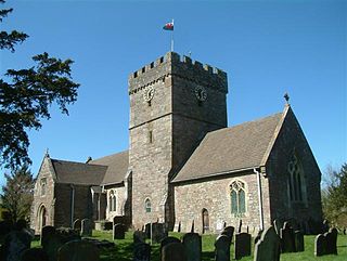
St. Brides Netherwent is a parish and largely deserted village in Monmouthshire, south-east Wales. It is centred 2 miles north of Magor, and 3 miles west of Caerwent. The A48 Newport to Chepstow road passes close by to the north.

<span class="mw-page-title-main">Shirenewton</span> Village and community in Monmouthshire, Wales, UK

Shirenewton is a village and community in Monmouthshire, south east Wales. It is located 3 miles due west of Chepstow, 5 miles (8 km) by road. The village stands around 500 feet above sea level, and has extensive views of the Severn Estuary and Bristol Channel. The population of the village and the conjoined village of Mynydd-bach was 657 in 2011.

<span class="mw-page-title-main">Caldicot railway station</span> Railway station in Monmouthshire, Wales

Caldicot railway station is a part of the British railway system owned by Network Rail and is operated by Transport for Wales. It serves the town of Caldicot in Monmouthshire, Wales. It is located between Chepstow and the city of Newport on the Gloucester line, 148 miles 2 chains (238.2 km) from the zero point at Paddington, measured via Stroud. The line to Bristol via the Severn Tunnel runs just to the north but there are no platforms here; however, Severn Tunnel Junction station is within walking distance for those wanting to travel to Bristol.

<span class="mw-page-title-main">Llanvair Discoed</span> Human settlement in Wales

Llanvair Discoed is a small village in Monmouthshire, south-east Wales, 6 miles west of Chepstow and 10 miles east of Newport.

<span class="mw-page-title-main">Kingdom of Gwent</span> Kingdom in South Wales

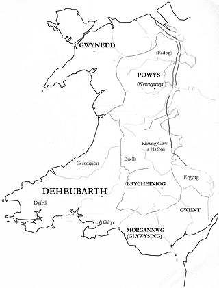
Gwent was a medieval Welsh kingdom, lying between the Rivers Wye and Usk. It existed from the end of Roman rule in Britain in about the 5th century until the Norman invasion of Wales in the 11th century. Along with its neighbour Glywyssing, it seems to have had a great deal of cultural continuity with the earlier Silures, keeping their own courts and diocese separate from the rest of Wales until their conquest by Gruffydd ap Llywelyn. Although it recovered its independence after his death in 1063, Gwent was the first of the Welsh kingdoms to be overrun following the Norman conquest.

<span class="mw-page-title-main">Llanthony Secunda Priory</span>

Llanthony Secunda Priory was a house of Augustinian canons in the parish of Hempsted, Gloucestershire, England, situated about 1/2 a mile south-west of Gloucester Castle in the City of Gloucester. It was founded in 1136 by Miles de Gloucester, 1st Earl of Hereford, a great magnate based in the west of England and the Welsh Marches, hereditary Constable of England and Sheriff of Gloucestershire, as a secondary house and refuge for the canons of Llanthony Priory in the Vale of Ewyas, within his Lordship of Brecknock in what is now Monmouthshire, Wales. The surviving remains of the Priory were designated as Grade I listed in 1952 and the wider site is a scheduled ancient monument. In 2013 the Llanthony Secunda Priory Trust received funds for restoration work which was completed in August 2018 when it re-opened to the public.

<span class="mw-page-title-main">Portskewett</span> Village and community in Monmouthshire, Wales

Portskewett is a village and community (parish) in Monmouthshire, south east Wales. It is located four miles south west of Chepstow and one mile east of Caldicot, in an archaeologically sensitive part of the Caldicot Levels on the Welsh shore of the Severn Estuary. The Second Severn Crossing passes overhead carrying the M4 motorway. The community includes Sudbrook, Crick and Leechpool.

<span class="mw-page-title-main">Sudbrook, Monmouthshire</span> Human settlement in Wales

Sudbrook is a village in Monmouthshire, south east Wales. It is located 4 miles south west of Chepstow and 1 mile east of Caldicot. It lies close to the Second Severn Crossing on the Severn Estuary, and adjoins the village of Portskewett. It was largely built in the late 19th century for workers on the Severn railway tunnel. At that time it was also known as Southbrook.

Chepstow Rural District was a rural district in the administrative county of Monmouthshire, Wales. It was established under the Local Government Act 1894, and was abolished in 1974 when its functions were assumed by the new Monmouth District Council.

<span class="mw-page-title-main">Portskewett Pier railway station</span> Former railway station in Wales

Portskewett Pier was a station on the Bristol & South Wales Union Railway. The pier at Black Rock, near Portskewett, was the Welsh side of the New Passage Ferry across the River Severn. The ferry linked rail services between Bristol and South Wales, avoiding the previous long detour through Gloucester. The ferry service lasted for nearly twenty five years, from 1863 to 1886, until the opening of the railway tunnel beneath the river.

Caldicot Castle is an electoral ward in the town of Caldicot, Monmouthshire, Wales. The ward elects councillors to Caldicot Town Council and Monmouthshire County Council.

<span class="mw-page-title-main">Nedern Brook Wetlands</span>

The Nedern Brook Wetland is a flood meadow habitat near Caldicot, Monmouthshire, Wales, designated since 1988 as a Site of Special Scientific Interest (SSSI). The site is of 44.5 hectares and is bridged by the M48 motorway. The spelling Neddern is used in some documents. Nedern Brook is also called Troggy Brook.

<span class="mw-page-title-main">Church Farmhouse, Caldicot</span> Building in Monmouthshire, Wales

Church Farmhouse, Caldicot, Monmouthshire is a substantial grange building which was a working farmhouse before 1205. It is connected to both Llanthony Prima in Monmouthshire and Llanthony Secunda in Gloucester. It was established as a grange farm for Llanthony Secunda Priory in the 12th century with the lands in Caldicot being given to the monastery in 1137. It is a Grade II* listed building. The adjacent barn has its own Grade II listing.

References

  1. "Caldicot". City population. Retrieved 25 October 2022.
  2. "Custom report - Nomis - Official Labour Market Statistics".
  3. "Custom report - Nomis - Official Labour Market Statistics". www.nomisweb.co.uk. Retrieved 27 July 2021.
  4. "Origins of the place name". Archived from the original on 9 February 2009. Retrieved 25 September 2008.
  5. "BBC - South East Wales Caldicot - Llanthony Secunda Manor - Ron Lapthorn talks about the history of this distinctive house in Caldicot, Monmouthshire". Archived from the original on 6 December 2008. Retrieved 13 January 2008.
  6. A reproduction of the map is at File:Atlas_Ortelius_KB_PPN369376781-011av-011br.jpg
  7. 1 2 3 "A Short History of Caldicot". Archived from the original on 22 October 2007. Retrieved 13 January 2008.
  8. "A Short History of Caldicot". Archived from the original on 22 October 2007. Retrieved 13 January 2008.
  9. Some Memorial Inscriptions, Caldicot, Monmouthshire
  10. "Rectorial Benefice of Caldicot". The Church in Wales. 21 October 2015. Retrieved 8 April 2016.
  11. "New £36m school opens in Caldicot". BBC News. 11 September 2017. Retrieved 22 October 2017.
  12. "Caldicot School New Build Update MCC". Monmouthshire. Archived from the original on 7 February 2017. Retrieved 6 February 2017.
  13. "BBC News article - Monmouthshire to get two new secondary schools by 2016". 17 January 2014.
  14. "Caldicot School new build cost update".
  15. "Your Councillors". Caldicot Town Council. Retrieved 6 January 2019.
  16. The County of Monmouthshire (Electoral Changes) Order 2002. Statutory Instruments. 6 December 2002. Retrieved 4 January 2019.{{cite book}}: |website= ignored (help)
  17. MonLeisure site
  18. Caldicot Leisure Centre Archived 2011-09-16 at the Wayback Machine
  19. Leisure Centre information