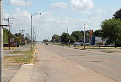
Canute, Oklahoma | |
---|---|
Coordinates: 35°25′19″N99°16′41″W / 35.42194°N 99.27806°W | |
Country | United States |
State | Oklahoma |
County | Washita |
Area | |
• Total | 0.63 sq mi (1.63 km2) |
• Land | 0.63 sq mi (1.63 km2) |
• Water | 0.00 sq mi (0.00 km2) |
Elevation | 1,887 ft (575 m) |
Population (2020) | |
• Total | 494 |
• Density | 782.88/sq mi (302.18/km2) |
Time zone | UTC-6 (Central (CST)) |
• Summer (DST) | UTC-5 (CDT) |
ZIP code | 73626 |
Area code | 580 |
FIPS code | 40-11650 [3] |
GNIS feature ID | 2413161 [2] |
Canute is a town in Washita County, Oklahoma, United States. The population was 541 at the 2010 census.
Canute was established in the early 1900s and is located on the now-defunct Rock Island Railroad. Following the advent of the automobile, Canute became a popular stop along U.S. Route 66 and a large number of tourist businesses were established, including gasoline service stations, motels and restaurants. However, when Interstate 40 bypassed the small village to the north in May 1970 and received only one exit from the freeway, the local economy went into a decline due to the bypass and the concurrent closure of nearby Clinton-Sherman Air Force Base at Burns Flat, leading most of those businesses to shut down. Today, Canute businesses include a bank and auto repair shop on Route 66, [4] along with a gas station/convenience store. Former Oklahoma governor David Walters was born in Canute.
According to the United States Census Bureau, the town has a total area of 0.6 square miles (1.6 km2), all land.
Climate data for Canute, Oklahoma | |||||||||||||
---|---|---|---|---|---|---|---|---|---|---|---|---|---|
Month | Jan | Feb | Mar | Apr | May | Jun | Jul | Aug | Sep | Oct | Nov | Dec | Year |
Mean daily maximum °F (°C) | 48.9 (9.4) | 54.3 (12.4) | 63.8 (17.7) | 74.1 (23.4) | 81.5 (27.5) | 89.5 (31.9) | 94.8 (34.9) | 93.1 (33.9) | 85 (29) | 74.9 (23.8) | 60.8 (16.0) | 50.5 (10.3) | 72.6 (22.6) |
Mean daily minimum °F (°C) | 23.6 (−4.7) | 27.9 (−2.3) | 36.3 (2.4) | 46.5 (8.1) | 55.7 (13.2) | 64.5 (18.1) | 68.9 (20.5) | 67.1 (19.5) | 59.5 (15.3) | 48.1 (8.9) | 36.4 (2.4) | 26.8 (−2.9) | 46.8 (8.2) |
Average precipitation inches (mm) | 0.7 (18) | 1.2 (30) | 2 (51) | 2.1 (53) | 4.6 (120) | 3.9 (99) | 1.9 (48) | 2.9 (74) | 3.3 (84) | 2 (51) | 1.7 (43) | 0.8 (20) | 26.9 (680) |
Source: Weatherbase.com [5] |
Census | Pop. | Note | %± |
---|---|---|---|
1930 | 366 | — | |
1940 | 374 | 2.2% | |
1950 | 355 | −5.1% | |
1960 | 370 | 4.2% | |
1970 | 420 | 13.5% | |
1980 | 676 | 61.0% | |
1990 | 542 | −19.8% | |
2000 | 524 | −3.3% | |
2010 | 541 | 3.2% | |
2020 | 494 | −8.7% | |
U.S. Decennial Census [6] |
As of the census [3] of 2000, there were 524 people, 214 households, and 145 families residing in the town. The population density was 854.2 inhabitants per square mile (329.8/km2). There were 242 housing units at an average density of 394.5 per square mile (152.3/km2). The racial makeup of the town was 88.36% White, 0.57% African American, 1.91% Native American, 0.19% Asian, 7.25% from other races, and 1.72% from two or more races. Hispanic or Latino of any race were 7.63% of the population.
There were 214 households, out of which 29.4% had children under the age of 18 living with them, 54.7% were married couples living together, 9.3% had a female householder with no husband present, and 31.8% were non-families. 28.0% of all households were made up of individuals, and 14.5% had someone living alone who was 65 years of age or older. The average household size was 2.45 and the average family size was 3.01.
In the town, the population was spread out, with 24.2% under the age of 18, 12.2% from 18 to 24, 25.4% from 25 to 44, 21.0% from 45 to 64, and 17.2% who were 65 years of age or older. The median age was 38 years. For every 100 females, there were 97.7 males. For every 100 females age 18 and over, there were 90.0 males.
The median income for a household in the town was $32,321, and the median income for a family was $38,036. Males had a median income of $26,406 versus $15,500 for females. The per capita income for the town was $20,283. About 13.7% of families and 15.6% of the population were below the poverty line, including 16.7% of those under age 18 and 22.5% of those age 65 or over.
Canute Elementary School is located at Third and Walk Street. The elementary serves students in Pre-K through 6th grade with an average of 32 students per class.
Canute Junior High and High School is located at 506 Third Street. The junior high serves students in 7th through 9th grades with 34 students per class on average. The high school serves students in 10th grade through 12th grade with an average of 30 students per class.
Cascade is a city in Dubuque and Jones counties, Iowa, United States. The Dubuque County portion is part of Dubuque Metropolitan Statistical Area, while the Jones County section is part of Cedar Rapids Metropolitan Statistical Area. The population was 2,386 at the 2020 census, up from 1,958 in 2000. The city is located within southwestern of Dubuque County and north-central Jones County.
Muscotah is a city in Atchison County, Kansas, United States. As of the 2020 census, the population of the city was 155. Muscotah was named after the Kickapoo Native American word for "prairie".
Marysville is a city in and the county seat of Marshall County, Kansas, United States. As of the 2020 census, the population of the city was 3,447.
Warrensburg is a city in and the county seat of Johnson County, Missouri, United States. The population was 20,313 at the 2020 census. The Warrensburg Micropolitan Statistical Area consists of Johnson County. The city is a college town as it is home to the University of Central Missouri.
Hendrix is a town in Bryan County, Oklahoma, United States. The population was 79 at both the 2010 and the 2000 censuses. According to the Bryan County Genealogy Society, Hendrix was originally known as Kemp City. This led to it often being confused with the neighboring town that is simply named Kemp. Hendrix was largely destroyed by a 1916 tornado.
Kansas is a town in Delaware County, Oklahoma, United States. The population was 802 at the 2010 census.
Hunter is a town in Garfield County, Oklahoma, United States. The population was 165 at the 2010 census, a 4.6 percent decline from the figure of 173 in 2000.
Bradley is a town in Grady County, Oklahoma, United States. The population was 78 at the 2020 United States census.
Carney is a town in Lincoln County, Oklahoma, United States. As of the 2020 census, the population of the town was 545.
Davenport is a town in Lincoln County, Oklahoma, United States. The population was 814 at the 2010 census.
Wayne is a town in McClain County, Oklahoma, United States. Wayne and McClain County are part of the Oklahoma City Metropolitan Area. The population was 625 at the 2020 census, a 9.2% decrease from 2010. Wayne is part of the "Heart of Oklahoma" exurban area south of Norman and Oklahoma City.
Oktaha is a town in Muskogee County, Oklahoma, United States.
Luther is a town in Oklahoma County, Oklahoma, United States, and a part of the Oklahoma City Metropolitan Area. The population was 1,221 at the 2010 census. Sperling Best Places lists the population of 4073 for the 73054 Luther zip code, which includes the town and immediate surrounding area of rural residents.
Shidler is a city in Osage County, Oklahoma, United States. The population was 328 in the 2020 census, a decline from the figure of 441 recorded in 2010.
Tribbey is a town in Pottawatomie County, Oklahoma, United States.The community was named for Alpheus M. Tribbey, landowner. The population was 337 by the 2020 United States census.
Central High is a town in Stephens County, Oklahoma, United States. The population was 1,181 at the time of the 2020 Census.
Foss is a town in Washita County, Oklahoma, United States. As of the 2010 census, the town population was 151, an 18.9 percent increase from 127 at the 2000 census.
Sentinel is a town in Washita County, in the U.S. state of Oklahoma. The population was 901 in the 2010 census, an increase of 4.9 percent from the figure of 859 residents in 2000. Towns near Sentinel are Rocky, Cordell, Canute, and Burnsflat.
Texhoma is a city in Sherman County, Texas, United States. The population was 258 at the 2020 census, declining from 364 in 2010. Texhoma is a divided city, with the Texas-Oklahoma state border separating the city from Texhoma, Oklahoma. It is also the northernmost settlement in the entire state of Texas.
Sherman is a village in the town of Sherman, Chautauqua County, New York, United States. The village lies in the northern part of the town at intersections of County Routes 15 and 18, NY-76 and NY-430. The population was 681 at the 2020 census.