Cape Borda, South Australia Last updated January 29, 2026 Climate Cape Borda has a warm-summer mediterranean climate (Köppen: Csb ) with tepid, dry summers and mild, relatively wet winters. [ 13] On average, the town experiences 181.0 cloudy days and only 49.2 clear days per annum. Extreme temperatures ranged from 40.0 °C (104.0 °F) on 28 January 2009 to 1.8 °C (35.2 °F) on 12 June 1999. [ 14] The wettest recorded day was 23 March 1877 with 93.7 mm (3.69 in) of rainfall. [ 15]
The original weather station recorded temperature, precipitation, solar exposure, 9 am & 3 pm conditions. It was closed in 2007.
Climate data for Cape Borda Comparison ( 35°45′S 136°35′E / 35.75°S 136.59°E / -35.75; 136.59 m (469 ft) AMSL) (1865-2007) Month Jan Feb Mar Apr May Jun Jul Aug Sep Oct Nov Dec Year Record high °C (°F) 39.0 36.8 34.0 29.2 24.8 20.4 20.0 22.0 26.5 32.6 34.4 37.0 39.0 Mean daily maximum °C (°F) 23.0 23.3 21.3 18.7 16.4 14.6 13.9 14.0 15.1 16.9 19.4 21.2 18.2 Mean daily minimum °C (°F) 13.8 14.3 13.5 12.4 11.2 9.8 9.1 8.9 9.3 10.0 11.2 12.5 11.3 Record low °C (°F) 6.1 8.0 7.2 6.7 3.3 1.8 2.2 2.2 2.8 3.3 4.1 6.0 1.8 Average precipitation mm (inches) 15.4 16.9 23.7 45.2 79.0 106.4 104.2 86.5 55.3 41.7 26.1 21.0 620.7 Average precipitation days (≥ 0.2 mm) 5.4 5.0 7.5 11.9 17.1 19.6 21.2 19.8 16.0 12.8 8.7 7.5 152.5 Average afternoon relative humidity (%) 54 55 59 65 71 73 74 72 70 65 59 58 65 Average dew point °C (°F) 10.9 11.3 11.1 10.3 9.8 8.6 7.9 7.6 8.0 8.3 8.8 10.2 9.4 Source: Bureau of Meteorology (1865-2007) [ 16]
A newer weather station was opened in 2002. It records temperature, precipitation & solar exposure.
Climate data for Cape Borda ( 35°45′S 136°36′E / 35.75°S 136.60°E / -35.75; 136.60 m (518 ft) AMSL) (2002-2025) Month Jan Feb Mar Apr May Jun Jul Aug Sep Oct Nov Dec Year Record high °C (°F) 40.0 37.9 35.5 30.3 24.6 20.9 18.1 21.0 25.6 31.1 36.2 39.1 40.0 Mean daily maximum °C (°F) 24.6 23.9 22.6 19.7 17.0 15.0 14.3 14.7 16.0 18.1 20.6 22.6 19.1 Mean daily minimum °C (°F) 14.5 14.5 13.8 12.6 11.2 9.9 9.3 9.2 9.5 10.2 11.7 13.0 11.6 Record low °C (°F) 7.0 8.7 7.7 6.0 5.1 2.9 3.9 3.4 2.6 3.5 4.5 6.0 2.6 Average precipitation mm (inches) 17.8 15.9 20.3 37.9 66.1 94.0 86.1 69.9 45.9 30.2 27.6 22.5 531.6 Average precipitation days (≥ 0.2 mm) 5.0 4.7 8.4 12.2 18.7 19.6 21.1 21.1 16.4 11.3 9.4 8.0 155.9 Source: Bureau of Meteorology (2002-2025) [ 5]
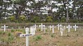
Harvey's Return cemetery
Harvey's Return plaque
References ↑ "Fleurieu and Kangaroo Island SA Government region" (PDF) . The Government of South Australia. Archived from the original (PDF) on 21 March 2019. Retrieved 9 September 2016 . 1 2 3 4 5 6 7 8 9 "Search result for "Cape Borda (Locality Bounded)" (Record no SA0050434 ) with the following layers being selected - "Suburbs and Localities", "Local Government Areas" and "Hundreds" . Department of Planning, Transport and Infrastructure . Archived from the original on 12 October 2016. Retrieved 8 March 2016 . 1 2 Mawson . Retrieved 2 March 2018 . 1 2 "Federal electoral division of Mayo, boundary gazetted 16 December 2011" (PDF) . Australian Electoral Commission. Retrieved 2 August 2015 . 1 2 3 4 5 "Cape Borda Climate Statistics (2002-2025)" . Bureau of Meteorology . Retrieved 14 January 2026 . ↑ Australian Bureau of Statistics (28 June 2022). "Cape Borda (suburb and locality)" . Australian Census 2021 QuickStats . Retrieved 28 June 2022 . 1 2 3 "Cape Borda, South Australia (Postcode)" . postcodes-australia.com. Retrieved 8 March 2016 . ↑ "Monthly climate statistics: Summary statistics CAPE BORDA" . Commonwealth of Australia, Bureau of Meteorology. Retrieved 8 March 2016 . ↑ "Development Plan, Kangaroo Island Council" (PDF) . Department of Planning, Transport and Infrastructure . pp. 263– 269. Retrieved 8 March 2016 . ↑ "Harveys Return Cemetery, Flinders Chase National Park (sic)" . South Australian Heritage Register . Department of Environment, Water and Natural Resources. Retrieved 27 March 2016 . ↑ "Cape Borda Lighthouse (originally 'Flinders Light') and Keepers' Cottages, Flinders Chase National Park" . South Australian Heritage Register . Department of Environment, Water and Natural Resources. Retrieved 27 March 2016 . ↑ "Harveys Return Landing Site, Flinders Chase National Park (sic)" . South Australian Heritage Register . Department of Environment, Water and Natural Resources. Retrieved 27 March 2016 . ↑ "Climate classification maps: Köppen - all classes" . Bureau of Meteorology . Retrieved 14 January 2026 . ↑ "Cape Borda Climate (1865-2007)" . FarmOnline Weather . Australian Community Media . Retrieved 14 January 2026 . ↑ "Cape Borda Comparison Climate (2002-2025)" . FarmOnline Weather . Australian Community Media . Retrieved 14 January 2026 . ↑ "Cape Borda Comparison Climate Statistics (1865-2007)" . Bureau of Meteorology . Retrieved 14 January 2026 .
This page is based on this
Wikipedia article Text is available under the
CC BY-SA 4.0 license; additional terms may apply.
Images, videos and audio are available under their respective licenses.