Carta Hydrographica y Chorographica de las Islas Filipinas

Last updated
Library of Congress copy Carta Hydrographica y Chorographica de las Yslas Filipinas Dedicada al Rey Nuestro Senor por el Mariscal d. Campo D. Fernando Valdes Tamon Cavallo del Orden de Santiago de Govor. Y Capn.jpg
Library of Congress copy

Carta Hydrographica y Chorographica de las Islas Filipinas (Spanish, " Hydrographical and Chorographical Chart of the Philippine Islands"), more commonly known as the Murillo Velarde map, is a map of the Philippines made and published in Manila in 1734 by the Spanish Jesuit cartographer Pedro Murillo Velarde, and two Filipinos; engraver Nicolás de la Cruz Bagay and artist Francisco Suarez. [1] [2] The World Digital Library describes it as the "first and most important scientific map of the Philippines". [3] It is frequently referred to as the "Mother of all Philippine Maps". [4] [5] [6]

Spanish language Romance language

Spanish or Castilian, is a Romance language that originated in the Iberian Peninsula and today has over 450 million native speakers in Spain and in the Americas. It is a global language and the world's second-most spoken native language, after Mandarin Chinese.

Hydrography Applied science of measurement and description of physical features of bodies of water

Hydrography is the branch of applied sciences which deals with the measurement and description of the physical features of oceans, seas, coastal areas, lakes and rivers, as well as with the prediction of their change over time, for the primary purpose of safety of navigation and in support of all other marine activities, including economic development, security and defence, scientific research, and environmental protection.

Chorography

Chorography is the art of describing or mapping a region or district, and by extension such a description or map. This term derives from the writings of the ancient geographer Pomponius Mela and Ptolemy, where it meant the geographical description of regions. However, its resonances of meaning have varied at different times. Richard Helgerson states that "chorography defines itself by opposition to chronicle. It is the genre devoted to place, and chronicle is the genre devoted to time". Darrell Rohl prefers a broad definition of "the representation of space or place".

Contents

Map

The map's title includes the following additional description: dedicada al Rey Nuestro Señor por el Mariscal d. Campo D. Fernando Valdes Tamon Cavallo del Orden de Santiago de Govor. Y Capn General de dichas Yslas (Spanish, "dedicated to the King Our Lord by Field Marshal Fernando Tamon Valdes, Knight of the Order of Santiago, Governor and Captain General of said Islands"). The map was created upon the behest of then governor-general Fernando Valdes y Tamon in response to an order from Philip V of Spain. [7]

Order of Santiago religious order founded in the 12th century, Spain and Portugal

The Order of Santiago, also known as the Order of St. James of the Sword, is a religious and military order founded in the 12th century. It owes its name to the Patron Saint of Spain, "Santiago". Its initial objective was to protect the pilgrim of St. James' Way, to defend Christendom and to remove the Muslim Moors from the Iberian Peninsula. Entrance was not however restricted to nobles of Spain exclusively, and so many of her members have been prominent Catholic Europeans in general. The Order of Santiago is one of the most renowned military orders in the history of the world, its insignia being particularly recognisable and abundant in Western art.

The Governor-General of the Philippines was the title of the government executive during the colonial period of the Philippines, governed mainly by Spain (1565–1898) and the United States (1898–1946), and briefly by Great Britain (1762–1764) and Japan (1942–1945). They were also the representative of the executive of the ruling power.

Philip V of Spain 18th-century King of Spain

Philip V was King of Spain from 1 November 1700 to his abdication in favour of his son Louis on 14 January 1724, and from his reaccession of the throne upon his son's death, 6 September 1724 to his own death on 9 July 1746.

The map shows maritime routes from Manila to Spain and New Spain. The Spanish royal coat of arms occupies a prominent space in the upper-middle portion of the map. On its flanks are twelve images, six to a side. Eight of these images depict various ethnic groups residing in the archipelago. The remaining four are cartographic depictions of cities and islands. The ethnic groups and individuals depicted include Chinese Filipinos ("Sangley") or Chinese, Kaffirs ("Cafres"), a Camarin (a native of Manila), a Lascar from India, mestizos, a Mardica (natives of Ternate and Tidore), a Japanese ("Japon"), Spaniards, Criollos, Filipino natives ("Indios"), Aetas, an Armenian, a Mughal, a native of the Malabar region and a Visayan. Maps of "Samboagan" (known today as Zamboanga City, a city in Mindanao), the port of Cavite, the island of "Guajan" (Guam) and Manila, and illustrations of endemic plants and animals occupy the remaining sections.

New Spain kingdom of the Spanish Empire (1535-1821)

The Viceroyalty of New Spain was an integral territorial entity of the Spanish Empire, established by Habsburg Spain during the Spanish colonization of the Americas. It covered a huge area that included territories in North America, South America, Asia and Oceania. It originated in 1521 after the fall of Mexico-Tenochtitlan, the main event of the Spanish conquest, which did not properly end until much later, as its territory continued to grow to the north. It was officially created on 8 March 1535 as a Kingdom, the first of four viceroyalties Spain created in the Americas. Its first viceroy was Antonio de Mendoza y Pacheco, and the capital of the kingdom was Mexico City, established on the ancient Mexico-Tenochtitlan.

Coat of arms of the King of Spain Coat of arms of the Spanish Monarch since 2014

The coat of arms of the King of Spain is the heraldic symbol representing the monarch of Spain. The current version of the monarch's coat of arms was adopted in 2014 but is of much older origin. The arms marshal the arms of the former monarchs of Castile, León, Aragon, and Navarre.

Archipelago A group of islands

An archipelago, sometimes called an island group or island chain, is a chain, cluster or collection of islands, or sometimes a sea containing a small number of scattered islands.

The Murillo Velarde map was widely reprinted. These include reproductions in Manila (1744), Vienna (1748) by Kaliwoda, Nuremberg (1760) by Lowitz, and in the first volume of Juan de la Concepcion's Historia General de Philipinas (1788). [7]

Copies

There are less than 50 extant copies of the map. [8] Some are mounted on a cloth backing measuring 112x120 cm. The map itself measures 108x71 cm and is on a scale approximating 1:1,400,000.

The scale of a map is the ratio of a distance on the map to the corresponding distance on the ground. This simple concept is complicated by the curvature of the Earth's surface, which forces scale to vary across a map. Because of this variation, the concept of scale becomes meaningful in two distinct ways. The first way is the ratio of the size of the generating globe to the size of the Earth. The generating globe is a conceptual model to which the Earth is shrunk and from which the map is projected.

Library of Congress (de facto) national library of the United States of America

The Library of Congress (LOC) is the research library that officially serves the United States Congress and is the de facto national library of the United States. It is the oldest federal cultural institution in the United States. The library is housed in three buildings on Capitol Hill in Washington, D.C.; it also maintains the National Audio-Visual Conservation Center in Culpeper, Virginia. The library's functions are overseen by the librarian of Congress, and its buildings are maintained by the architect of the Capitol. The Library of Congress claims to be the largest library in the world. Its "collections are universal, not limited by subject, format, or national boundary, and include research materials from all parts of the world and in more than 450 languages."

Washington, D.C. Capital of the United States

Washington, D.C., formally the District of Columbia and commonly referred to as Washington or D.C., is the capital of the United States. Founded after the American Revolution as the seat of government of the newly independent country, Washington was named after George Washington, the first president of the United States and a Founding Father. As the seat of the United States federal government and several international organizations, Washington is an important world political capital. The city, located on the Potomac River bordering Maryland and Virginia, is one of the most visited cities in the world, with more than 20 million tourists annually.

Biblioteca Nacional de España major public library, the largest in Spain and one of the largest libraries in the world

The Biblioteca Nacional de España is a major public library, the largest in Spain, and one of the largest in the world. It is located in Madrid, on the Paseo de Recoletos.

Reduced version

Murillo Velarde also published a smaller version of the Carta Hydrographica y Chorographica de las Yslas Filipinas, one that did not include the twelve illustrations on the map's flanks. This version measures 51x33 cm. and was published in 1744. [6] There are extant copies in the collections of the Lopez Museum, National Library of the Philippines [8] and the Boston Public Library Norman B. Leventhal Map Center. [12]

South China Sea disputes

The Murillo Velarde map has been instrumental in the Philippines' efforts to assert territorial rights in the South China Sea. The map, along with 270 other maps, was used by the Philippines' team of experts to refute China's historic claim of ownership of the entire South China Sea, [11] as it features Scarborough Shoal then labelled as "Panacot", as well as "Los Bajos de Paragua" now known as the Spratly Islands. [13] In 2016 the Permanent Court of Arbitration ruled in favor of the Philippines stating that China had "no historical rights" based on their Nine-Dash Line map. China however, rejected the ruling, [14] and Philippine President Rodrigo Duterte has decided not to act upon it. [15]

Related Research Articles

Philippines Republic in Southeast Asia

The Philippines, officially the Republic of the Philippines, is an archipelagic country in Southeast Asia. Situated in the western Pacific Ocean, it consists of about 7,641 islands that are categorized broadly under three main geographical divisions from north to south: Luzon, Visayas and Mindanao. The capital city of the Philippines is Manila and the most populous city is Quezon City, both part of Metro Manila. Bounded by the South China Sea on the west, the Philippine Sea on the east and the Celebes Sea on the southwest, the Philippines shares maritime borders with Taiwan to the north, Japan to the northeast, Vietnam to the west, Palau to the east, and Malaysia and Indonesia to the south.

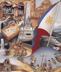
Juan de Salcedo was a Spanish conquistador. He was born in Mexico in 1549 and he was the grandson of Miguel López de Legazpi and brother of Felipe de Salcedo. Salcedo was one of the soldiers who accompanied the Spanish colonization of the Philippines in 1565. He joined the Spanish military in 1564 for their exploration of the East Indies and the Pacific, at the age of 15. In 1567, Salcedo led an army of about 300 Spanish and Mexican soldiers and 600 Visayan (Filipino) allies along with Martín de Goiti for their conquest of Islamic Manila. There they fought a number of battles against the Muslim leaders, mainly against Tarik Sulayman. The Spanish officers, Mexican recruits and Filipino warriors coalesced in 1570 and 1571 to attack the Islamised areas of Luzon, for control of lands and settlements.

Tondo, Manila Place in National Capital Region, Philippines

Tondo is a district located in Manila, Philippines. It is the largest in terms of area and population of Manila's sixteen districts, with a Census-estimated 631,313 people in 2015 and consists of two congressional districts. It is also the most densely populated district in the city.

Bathala deity

According to the indigenous religious beliefs of the Tagalog people, Bathala is the all-mighty deity who created the universe. A descriptive honorific is often attached to his name, describing him as the Bathalang Maylicha and as the Bathalang Maycapal.

Jacques-Nicolas Bellin French hydrographer, geographer and member of the philosophes

Jacques Nicolas Bellin was a French hydrographer, geographer, and member of the French intellectual group called the philosophes.

Scarborough Shoal Shoal in the South China Sea

Scarborough Shoal, also known as Huangyan Dao ,, Bajo de Masinloc (Spanish),, and Democracy Reef are two rocks in a shoal located between the Macclesfield Bank and Luzon island in the West Philippine Sea.

Ayala Museum Art and history museum in , Ayala Museum Building

The Ayala Museum is a museum in Makati, Metro Manila, Philippines. It is located in Ayala Center adjacent to Greenbelt mall and is run privately by the Ayala Foundation. This six-storey edifice houses ethnographic and archaeological exhibits on Filipino culture, art, and history. Since its establishment in 1967, the museum has been committed to showcasing overseas collections and situating contemporary Philippine art in the global arena in a two-way highway of mutual cooperation and exchange with local and international associates.

Epifanio de los Santos Filipino politician

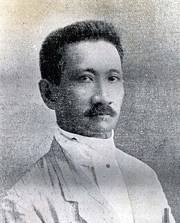
Epifanio de los Santos y Cristóbal, sometimes known as Don Pañong or Don Panyong was a noted Filipino historian, literary critic, art critic, jurist, prosecutor, antiquarian, archivist, scholar, painter, poet, musician, musicologist, philosopher, philologist, bibliographer, translator, journalist, editor, publisher, paleographer, ethnographer, biographer, researcher, civil servant, patriot and hero. He was appointed Director of the Philippine Library and Museum by Governor General Leonard Wood in 1925.

Manuel Artigas y Cuerva was a historian and journalist. He was born in Tacloban, Leyte, on October 15, 1866. His parents were Miguel Artigas y Rodriguez, a Spaniard from Cadiz, Spain and Soledad Cuerva y Molina of Bulacan. They were originally from Baler but they moved to Leyte in 1860 when Soledad's father, an officer in the artillery corps, was transferred.

Malolos Constitution

The Political Constitution of 1899, informally known as the Malolos Constitution, was the basic law of the First Philippine Republic. It was written by Felipe Calderón y Roca and Felipe Buencamino as an alternative to a pair of proposals to the Malolos Congress by Apolinario Mabini and Pedro Paterno. After a lengthy debate in the latter part of 1898, it was promulgated on 21 January 1899.

Dimasaua, also spelled Dimasawa and Dimasava, was the invented name created by 17th-century Spanish missionary Fr. Francisco Colín, S.J., pointing to a tiny isle in southern Leyte whose chief, according to Colín, "gave the most signal service" to Ferdinand Magellan and his crew at the port of Butuan in March–April 1521.

Names of the Philippines

The name Philippines derives from that of the 16th-century Spanish king Philip II, and is a truncated form of Philippine Islands. During the expedition of Ruy López de Villalobos to the region, the Spanish sailor Bernardo de la Torre bestowed the name Las Islas Filipinas on the islands of Leyte and Samar, in honor of the then Prince of Asturias. Despite the existence of other names, Filipinas ("Philippines") was eventually adopted as the name of the entire archipelago.

<i>Doctrina Christiana</i>

The Doctrina Christiana was an early book on the Catholic Catechism, written in 1593 by Fray Juan de Plasencia, and is believed to be one of the earliest printed books in the Philippines.

1898 in the Philippines details events of note that happened in the Philippines in the year 1898.

Philippines–Spain relations Diplomatic relations between the Republic of the Philippines and the Kingdom of Spain

The Philippines–Spain relations is a bilateral and multilateral relations between the Philippines and Spain.

Madja-as pre-Hispanic (c.1200–1569) Philippine state located on the islands of Panay and Negros

The Confederation of Madya-as was a legendary pre-Hispanic supra-barangay polity in island of Panay in Philippines. It was mentioned in Pedro Monteclaro's book titled Maragtas. It was supposedly created by Datu Sumakwel to exercise his authority over all the other datus of Panay. Like the Maragtas and the Code of Kalantiaw, the historical authenticity of the confederation is disputed, as no other documentation for Madya-as exists outside of Monteclaro's book.

Caboloan sovereign pre-colonial (c.1406–1576) Philippine polity located in the fertile Agno River basin and delta, with Binalatongan as the capital

Caboloan, referred to Chinese records as Feng-chia-hsi-lan, was a sovereign pre-colonial Philippine polity located in the fertile Agno River basin and delta, with Binalatongan as the capital. The polity of Pangasinan sent emissaries to China in 1406–1411.

Fernando Canon Filipino revolutionary general, inventor

Fernando Canon Faustino y Alumno , was a Filipino revolutionary general, poet, inventor, engineer,musician and Philippines 1st National Chess Champion on 1908.

Balarao

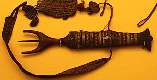
Balarao, also known as "winged dagger", is a Filipino dagger used throughout the pre-colonial Philippines. It is unusually shaped, with a leaf-like blade and a finger-fitting grip consisting of two horn-like projections at the pommel and no guards. The tang also protrudes at the back. The dagger is a status symbol among nobility and warriors and is usually finely-worked with precious metals, ivory, and horn.

References

  1. 1 2 "Carta hydrographica y chorographica de las Yslas Filipinas : dedicada al Rey Nuestro Señor por el Mariscal d. Campo D. Fernando Valdes Tamon Cavallo del Orden de Santiago de Govor. Y Capn". Library of Congress . Retrieved 4 January 2019.
  2. "Chairman Velarde donates replicas of 1734 Murillo-Velarde Map". Asian Institute of Journalism and Communication . Retrieved 4 January 2018.
  3. "A Hydrographical and Chorographical Chart of the Philippine Islands". World Digital Library. 8 January 2018. Retrieved 4 January 2019.
  4. 1 2 "We Have the Mysterious Map that Proves the West Philippine Sea is Ours". Esquire Philippines . 4 May 2017. Retrieved 4 January 2019.
  5. Mariano, Jose Vionel F. (30 August 2017). "Army receives replica of Mother of all Philippine Maps". Philippine Army . Retrieved 4 January 2018.
  6. 1 2 "The Mother of Philippine Maps". Lopez Museum. 9 November 2009. Retrieved 4 January 2019.
  7. 1 2 Mojarro, Jorge R. (12 June 2015). "The Murillo Velarde map: A relic from 1734 amid the rough seas of 2015". BusinessWorld . Retrieved 4 January 2019.
  8. 1 2 3 4 Ocampo, Ambeth R. (10 June 2015). "Rare, important and significant". The Philippine Daily Inquirer . Retrieved 4 January 2019.
  9. "Carta Hydrographica y Chorographica de las Yslas Filipinas Dedicada al Rey Nuestro Señor por el Mariscal d. Campo D. Fernando Valdes Tamon Cavallº del Orden de Santiago de Govor. Y Capn. Hecha pr. el Pe. Pedro Murillo Velarde dla. Compª d. Ihs. Cathco. d. De Canones sobre los Mapas y Relaciones mejores que han salido, y observaciones del Author ; delineavit Nicolas de la Cruz Bagay Indio [Tagalo en Manl. Año 1734]" . Retrieved 4 January 2019.
  10. Tordesillas, Ellen T. (7 June 2015). "PH to submit 300-year-old map to UN in case vs China" . Retrieved 4 January 2019.
  11. 1 2 "UPD gets replica of 1734 Murillo Velarde map". University of the Philippines Diliman. 18 October 2018. Retrieved 4 January 2019.
  12. "Mapa de las yslas Philipinas". Boston Public Library . Retrieved 5 January 2019.
  13. Layug, Margaret Claire (11 September 2017). "Murillo Velarde Map refutes 'false history', China's claims – Carpio". GMA News . Retrieved 4 January 2019.
  14. Phillips, Tom (12 July 2016). "Beijing rejects tribunal's ruling in South China Sea case". The Guardian . Retrieved 4 January 2019.
  15. Salaverria, Leila B. (18 December 2016). "Duterte to set aside UN tribunal ruling on maritime dispute". Philippine Daily Inquirer . Retrieved 4 January 2019.