
Bacon Peak is a mountain located in North Cascades National Park, in the Cascade Range in the U.S. state of Washington. Its glaciers cover 1.2 square miles (3.2 km2); the three main glaciers are Diobsud Creek Glacier, Green Lake Glacier and Noisy Creek Glacier.

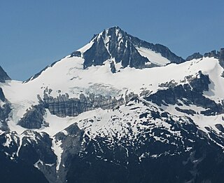
Klawatti Peak is located in North Cascades National Park in the U.S. state of Washington. Klawatti Peak is a nunatak, a peak surrounded by glaciers. These are Klawatti Glacier to the east, McAllister Glacier to the northwest and Inspiration Glacier to the south.
Primus Peak is located in North Cascades National Park in the U.S. state of Washington. Primus Peak is flanked by North Klawatti Glacier to the south and Borealis Glacier to the northeast. Tricouni Peak is situated immediately east of Primus Peak.

Sinister Peak is in Mount Baker-Snoqualmie and Wenatchee National Forests in the U.S. state of Washington. It is situated in Glacier Peak Wilderness and the North Cascades. Not quite 1 mi (1.6 km) east of Dome Peak, Sinister Peak is along a high ridge connecting the two peaks. The Chickamin Glacier is on the north slopes of Sinister Peak while the Garden Glacier is just southeast. Though some of the routes to the summit are technical, it can be reached by a moderate scramble.

Whatcom Peak is in North Cascades National Park in the U.S. state of Washington. Whatcom Peak is .50 mi (0.80 km) north of Challenger Glacier and the Whatcom Glacier descends from the northeast slopes of the peak. An unnamed hanging glacier descends along the northwest flank of the peak. This mountain is set between Mount Challenger and Easy Peak.

Kimtah Peak, elevation 8,600+ feet, is in North Cascades National Park in the U.S. state of Washington. Kimtah Peak is a summit along a ridge known as Ragged Ridge. Kimtah Glacier is on the northwest slopes of the peak, while Katsuk Glacier is to the northeast.
Mount Fury, elevation 8,280+ ft, is in North Cascades National Park in the U.S. state of Washington. Several small glaciers are on the slopes of Mount Fury, and it is the second tallest peak in the Picket Range, after Luna Peak which lies 2.6 mi (4.2 km) to the northeast.

McMillan Spire is a mountain peak in the Picket Range in the U.S. state of Washington and within North Cascades National Park. The peak lies .75 mi (1.21 km) east of Mount Degenhardt, and 0.47 mi (0.76 km) east of Inspiration Peak. The subpeak known as East McMillan Spire is .14 mi (0.23 km) east of McMillan Spire and they are collectively referred to as the McMillan Spires. The Terror Glacier lies to the west of the peak.

Snowfield Peak is in North Cascades National Park in the U.S. state of Washington. Located in the south unit of the park, Snowfield Peak is .70 mi (1.13 km) east of the summit known as Horsemans Pack and the Neve Glacier descends from the north slopes of the mountain.

Neve Peak is in North Cascades National Park in the U.S. state of Washington. Located in the south unit of the park, Neve Peak is .66 mi (1.06 km) west of Colonial Peak. The Neve Glacier is just south of Neve Peak while the Colonial Glacier descends from the north slopes of the mountain.

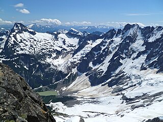
Austera Peak is in North Cascades National Park in the U.S. state of Washington. Located in the south unit of the park, Austera Peak is about 1 mi (1.6 km) north of Klawatti Peak and the same distance south of Primus Peak. The North Klawatti Glacier, Klawatti Glacier and the north section of McAllister Glacier all descend from the slopes of Austera Peak. Austera Peak is the highpoint along an arête known as Austera Towers.

Icy Peak is a 7,073-foot (2,156-metre) Skagit Range mountain summit located in the North Cascades of Washington state. It is situated in North Cascades National Park at the head of Nooksack Cirque. High ridges connect it to Seahpo Peak and Mount Shuksan. An icefall occupies the northeast cirque, and small glaciers clad all sides of the peak. Precipitation runoff drains into the Nooksack and Baker Rivers.

Trapper Mountain is a 7,530-foot (2,295-metre) summit located in Chelan County of Washington state. It is part of the North Cascades Range. Trapper Mountain is situated southeast of Cascade Pass on the shared border of North Cascades National Park and Glacier Peak Wilderness. The nearest higher peak is Hurry-up Peak, 0.92 miles (1.48 km) to the west. Surface runoff from the mountain drains into Trapper Lake and tributaries of the Stehekin River.

Magic Mountain is a 7,610-foot (2,320-metre) mountain summit located on the shared boundary of Skagit County and Chelan County in Washington state. It is part of the North Cascades, a subset of the Cascade Range. Magic Mountain is situated southeast of Cascade Pass on the shared border of North Cascades National Park and Glacier Peak Wilderness. The nearest peak is Pelton Peak 0.4 miles (0.64 km) to the northeast, and the nearest higher peak is Hurry-up Peak 0.83 miles (1.34 km) to the south. The Yawning Glacier and Cache Col Glacier rest on its northern flank. Magic Mountain is at the northern end of the Ptarmigan Traverse. Surface runoff on the north side the mountain drains into the Stehekin River, while precipitation drains into the Cascade River from the southwest side.

Inspiration Peak is a 7,891-foot (2,405-metre) mountain summit located in the Picket Range within North Cascades National Park in the state of Washington. The peak lies 0.28 mi (0.45 km) east of Mount Degenhardt, and 0.47 mi (0.76 km) west of McMillan Spires. Terror Glacier remnants lie to the south of the peaks, and the McMillan Cirque glaciers hang on the north slopes. The first ascent of Inspiration Peak was made in 1940 by Fred Beckey and his brother Helmy via the West Ridge. Inspiration Peak can be seen from the North Cascades National Park Newhalem visitor center, weather permitting.
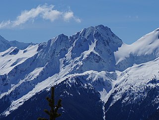
Tricouni Peak is an 8,102-foot (2,469-metre) mountain summit located in Skagit County of Washington state. It is situated in North Cascades National Park, north of the North Klawatti Glacier and southeast of the Borealis Glacier. The nearest higher peak is Primus Peak, 0.54 mi (0.87 km) to the west. Precipitation runoff from Tricouni drains into Thunder Creek. The peak is named for the tricouni which was used for traction on ice, and the approach to the peak involves traversing a glacier.

Indian Head Peak is a prominent 7,448-foot (2,270-metre) mountain summit located in the Glacier Peak Wilderness, in the North Cascades of Washington state. The mountain is situated in Chelan County, on land managed by the Okanogan–Wenatchee National Forest. Its nearest higher neighbor is Kololo Peaks, 3.29 mi (5.29 km) to the north. Indian Head Peak is the second-highest point on Wenatchee Ridge, a subrange which also includes Mount Saul, Whittier Peak, and Mount David. Precipitation runoff from the peak drains into Indian Creek and White River which are tributaries of the Wenatchee River.
Kololo Peaks is an 8,200+ ft mountain located in the Glacier Peak Wilderness of the North Cascades in Washington state. The mountain is situated on the crest of the Cascade Range, on the shared border of Snohomish County and Chelan County, and also straddling the boundary between Mount Baker-Snoqualmie National Forest and Wenatchee National Forest. The nearest higher peak is Glacier Peak, 3.29 mi (5.29 km) to the north. Precipitation runoff and meltwater from the White River Glacier on the southeast slope drains into White River. On the west slope, the White Chuck Glacier drains into the White Chuck River, and the Suiattle Glacier and Honeycomb Glacier on the north and east sides drain into the Suiattle River. Surrounded by these glaciers, Fred Beckey in his Cascade Alpine Guide describes the mountain as being almost a nunatak.

Johnson Mountain is a 6,721-foot (2,049-metre) mountain summit located in the Glacier Peak Wilderness of the North Cascades in Washington state. The mountain is situated in eastern Snohomish County, in the Mt. Baker-Snoqualmie National Forest. The nearest higher peak is White Mountain, 3.3 mi (5.3 km) to the northeast, along with Indian Head Peak 3.38 mi (5.44 km) to the east. Precipitation runoff from the mountain drains into tributaries of the Sauk River. The mountain's name honors Mackinaw Johnson, a prospector who had a cabin in the vicinity.
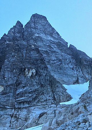
Early Morning Spire is an 8,200-foot (2,499-metre) mountain summit located in North Cascades National Park, in Skagit County of Washington state. The peak lies 0.29 mi (0.47 km) west-northwest of Dorado Needle, 1.05 mi (1.69 km) north-northwest of Eldorado Peak and 1.08 mi (1.74 km) southeast of Perdition Peak. It can be seen from the North Cascades Highway, west of Marblemount at a road pullout alongside the Skagit River. The first ascent of the peak was made in 1971 by Richard Emerson and Tom Hornbein via the Southwest Face. They made a chilly bivouac near the summit, which is how the peak's name came to be. Precipitation runoff from the mountain drains into Marble Creek, a tributary of the Cascade River.


