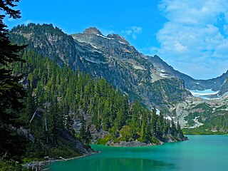
Columbia Peak is a mountain peak in the Henry M. Jackson Wilderness in the U.S. state of Washington. Columbia Peak rises to 7,172 feet (2,186 m). Together with Monte Cristo Peak and Kyes Peak it forms a basin that contains Columbia Glacier and Blanca Lake.
Primus Peak is located in North Cascades National Park in the U.S. state of Washington. Primus Peak is flanked by North Klawatti Glacier to the south and Borealis Glacier to the northeast. Tricouni Peak is situated immediately east of Primus Peak.
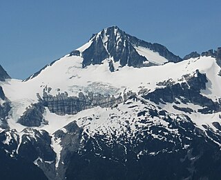
Mount Fury, elevation 8,280+ ft, is in North Cascades National Park in the U.S. state of Washington. Several small glaciers are on the slopes of Mount Fury, and it is the second tallest peak in the Picket Range, after Luna Peak which lies 2.6 mi (4.2 km) to the northeast.

McMillan Spire is a mountain peak in the Picket Range in the U.S. state of Washington and within North Cascades National Park. The peak lies .75 mi (1.21 km) east of Mount Degenhardt, and 0.47 mi (0.76 km) east of Inspiration Peak. The subpeak known as East McMillan Spire is .14 mi (0.23 km) east of McMillan Spire and they are collectively referred to as the McMillan Spires. The Terror Glacier lies to the west of the peak.

Snowfield Peak is in North Cascades National Park in the U.S. state of Washington. Located in the south unit of the park, Snowfield Peak is .70 mi (1.13 km) east of the summit known as Horsemans Pack and the Neve Glacier descends from the north slopes of the mountain.

Sourdough Mountain is in North Cascades National Park in the U.S. state of Washington. The Sourdough Mountain Lookout, is a fire lookout that was built by the Civilian Conservation Corps in 1933 near the summit. The lookout was placed on the National Register of Historic Places in 1989.

Golden Horn is an 8,366-foot (2,550-metre) mountain summit located in Okanogan County in Washington, United States. It is part of the Okanogan Range which is a sub-range of the North Cascades Range. Golden Horn is situated north of Methow Pass at headwaters of the Methow River, on land administered by the Okanogan–Wenatchee National Forest. It ranks as the 101st-highest summit in Washington. The nearest higher neighbor is Tower Mountain, 1.67 miles (2.69 km) to the southeast. Topographic relief is significant as the summit rises approximately 3,366 feet above the West Fork Methow River in one mile (1.6 km). The first ascent of Golden Horn was made by Fred Beckey, Keith Rankin, and Charles Welsh on September 18, 1946.

The Needles is an 8,160-foot (2,487-metre) granite mountain located in Okanogan County in Washington state. It is part of the Okanogan Range which is a sub-range of the North Cascades Range. The Needles is situated on land administered by the Okanogan–Wenatchee National Forest. Precipitation runoff from the peak drains into tributaries of the Methow River. Topographic relief is significant as the summit rises 3,660 feet above Pine Creek in approximately 1.25 mile (2 km). The nearest higher neighbor is Tower Mountain, 2.26 miles (3.64 km) to the southwest.

Gilbert Mountain is an 8,023-foot (2,445-metre) massif located in Okanogan County in Washington state. It is part of the Methow Mountains which are a subrange of the North Cascades. The mountain is situated within the Lake Chelan-Sawtooth Wilderness which is managed by Okanogan–Wenatchee National Forest. The northwestern extreme of the Gilbert massif connects to the southern end of Kangaroo Ridge. Precipitation runoff from the mountain drains into the Twisp River. Topographic relief is significant as it rises over 4,000 feet above the river in approximately one mile.
Beebe Mountain is a 7,416-foot (2,260-metre) mountain summit located in the Cascade Range in the U.S. state of Washington. It is situated on the border of North Cascades National Park. Its nearest higher neighbor is Elija Ridge, 1.86 miles (2.99 km) to the southwest, and McKay Ridge is set 4 miles (6.4 km) to the northeast on the opposite side of the North Cascades Highway. The mountain's name honors Frank Beebe who worked for the Forest Service and maintained a cabin near the base of the mountain in the 1920s. Precipitation runoff on the mountain drains into Ross Lake via Granite Creek and Panther Creek.

Trapper Mountain is a 7,530-foot (2,295-metre) summit located in Chelan County of Washington state. It is part of the North Cascades Range. Trapper Mountain is situated southeast of Cascade Pass on the shared border of North Cascades National Park and Glacier Peak Wilderness. The nearest higher peak is Hurry-up Peak, 0.92 miles (1.48 km) to the west. Surface runoff from the mountain drains into Trapper Lake and tributaries of the Stehekin River.

Mix-up Peak, also known as Mixup Peak, is a 7,440-foot (2,270-metre) mountain summit located on the shared boundary of Skagit County and Chelan County in Washington state. It is part of the North Cascades Range and is situated one mile south of Cascade Pass on the shared border of North Cascades National Park and Glacier Peak Wilderness. The nearest higher peak is Magic Mountain, 1.02 miles (1.64 km) to the east-southeast. Mix-up Peak is at the northern end of the Ptarmigan Traverse which is an alpine route to remote mountains such as Mount Formidable and Dome Peak. The Cache Glacier occupies a cirque below its eastern flank. Surface runoff on the east side the mountain drains into the Stehekin River, whereas precipitation runoff drains into the Cascade River from the west side.

Repulse Peak is a 7,923-foot (2,415-metre) mountain summit in the North Cascades in the U.S. state of Washington. It is located on the border of the Stephen Mather Wilderness and North Cascades National Park. It is situated midway between Black Peak and Fisher Peak, and can be seen from the North Cascades Highway. Precipitation runoff from Repulse Peak drains into tributaries of the Skagit River and Stehekin River. Topographic relief is significant as the east face rises over 2,900 feet in 0.53 mile (0.85 km).

Alta Mountain is a 6,275-foot (1,913-metre) mountain summit located in Kittitas County of Washington state. It is set within the Alpine Lakes Wilderness which is part of the Cascade Range. Alta Mountain is situated on land managed by Wenatchee National Forest. Precipitation runoff from the mountain drains into tributaries of the Yakima River.

Jumbo Mountain is a 5,825-foot-elevation (1,775-meter) summit near the western edge of the North Cascades, in Snohomish County of Washington state. It is located four miles south of Darrington, Washington, along the Mountain Loop Highway. It is situated in the Boulder River Wilderness on land administered by the Mount Baker-Snoqualmie National Forest. The mountain was named by miners for its resemblance to an elephant. The nearest higher peak is Buckeye Peak, 3.34 miles (5.38 km) to the west. Precipitation runoff from Jumbo Mountain drains into tributaries of the Stillaguamish River and Sauk River.

Preacher Mountain is a broad summit located in King County of Washington state. It's located at the western edge of the Cascade Range and is within the Alpine Lakes Wilderness on land managed by Mount Baker-Snoqualmie National Forest. The nearest higher peak is Kaleetan Peak, 3.11 miles (5.01 km) to the southeast. The Pulpit is situated 2.19 miles to the northwest. Precipitation runoff from the mountain drains into tributaries of the Snoqualmie River.

Cascade Peak is a 7,428-foot (2,264-metre) mountain summit located in Skagit County of Washington state. It is in the North Cascades, which is a subrange of the Cascade Range. The peak is situated above Cascade Pass, on the shared border of North Cascades National Park and Glacier Peak Wilderness. The nearest higher peak is Johannesburg Mountain, 0.53 miles (0.85 km) to the west-southwest, and The Triplets stand guard 0.35 miles (0.56 km) to the east-southeast. Surface runoff from the mountain drains into the Cascade River.

Inspiration Peak is a 7,891-foot (2,405-metre) mountain summit located in the Picket Range within North Cascades National Park in the state of Washington. The peak lies 0.28 mi (0.45 km) east of Mount Degenhardt, and 0.47 mi (0.76 km) west of McMillan Spires. Terror Glacier remnants lie to the south of the peaks, and the McMillan Cirque glaciers hang on the north slopes. The first ascent of Inspiration Peak was made in 1940 by Fred Beckey and his brother Helmy via the West Ridge. Inspiration Peak can be seen from the North Cascades National Park Newhalem visitor center, weather permitting.
Tricouni Peak is an 8,102-foot (2,469-metre) mountain summit located in Skagit County of Washington state. It is situated in North Cascades National Park, north of the North Klawatti Glacier and southeast of the Borealis Glacier. The nearest higher peak is Primus Peak, 0.54 mi (0.87 km) to the west. Precipitation runoff from Tricouni drains into Thunder Creek. The peak is named for the tricouni which was used for traction on ice, and the approach to the peak involves traversing a glacier.
Kololo Peaks is an 8,200+ ft mountain located in the Glacier Peak Wilderness of the North Cascades in Washington state. The mountain is situated on the crest of the Cascade Range, on the shared border of Snohomish County and Chelan County, and also straddling the boundary between Mount Baker-Snoqualmie National Forest and Wenatchee National Forest. The nearest higher peak is Glacier Peak, 3.29 mi (5.29 km) to the north. Precipitation runoff and meltwater from the White River Glacier on the southeast slope drains into White River. On the west slope, the White Chuck Glacier drains into the White Chuck River, and the Suiattle Glacier and Honeycomb Glacier on the north and east sides drain into the Suiattle River. Surrounded by these glaciers, Fred Beckey in his Cascade Alpine Guide describes the mountain as being almost a nunatak.


