
Leicestershire is a ceremonial county in the East Midlands of England. It is bordered by Derbyshire, Nottinghamshire, and Lincolnshire to the north, Rutland to the east, Northamptonshire to the south-east, Warwickshire to the south-west, and Staffordshire to the west. The city of Leicester is the largest settlement and the county town.

Uxbridge is a suburban town in west London, England, and the administrative headquarters of the London Borough of Hillingdon, 15.4 miles (24.8 km) northwest of Charing Cross. Uxbridge formed part of the parish of Hillingdon in the county of Middlesex. As part of the suburban growth of London in the 20th century it expanded and increased in population, becoming a municipal borough in 1955, and part of Greater London in 1965.
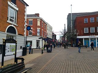
Nuneaton is a market town in Warwickshire, England, close to the county border with Leicestershire to the north-east. Nuneaton's population at the 2021 census was 88,813, making it the largest town in Warwickshire. Nuneaton's urban area, which also includes the large villages of Bulkington and Hartshill, had a population of 99,372 at the 2021 census.
Hinckley and Bosworth is a local government district with borough status in Leicestershire, England. The council is based in Hinckley, the largest town. The borough also includes the town of Earl Shilton and numerous villages and surrounding rural areas. The Bosworth in the borough's name refers to the small market town of Market Bosworth, near which the Battle of Bosworth Field was fought in 1485.

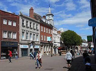
Hinckley is a market town in south-west Leicestershire, England. It is administered by Hinckley and Bosworth Borough Council. Hinckley is the third largest settlement in Leicestershire, after Leicester and Loughborough. Hinckley is about halfway between Leicester and Coventry and borders Nuneaton in Warwickshire. Watling Street forms part of the Leicestershire/Warwickshire border. The town forms an urban area with the village of Burbage, directly to the south.

Market Bosworth is a market town and civil parish in Leicestershire, England. At the 2001 Census, it had a population of 1,906, increasing to 2,097 at the 2011 census. It is most famously near to the site of the decisive final battle of the Wars of the Roses.

Devizes is a market town and civil parish in Wiltshire, England. It developed around Devizes Castle, an 11th-century Norman castle, and received a charter in 1141. The castle was besieged during the Anarchy, a 12th-century civil war between Stephen of England and Empress Matilda, and again during the English Civil War when the Cavaliers lifted the siege at the Battle of Roundway Down and the Parliamentarian Army of the West under Sir William Waller was routed. Devizes remained under Royalist control until 1645, when Oliver Cromwell attacked and forced the Royalists to surrender. The castle was destroyed in 1648 on the orders of Parliament, and today little remains of it.

Sutton Cheney is a village and former civil parish, now in the parish of Dadlington and Sutton Cheney, in the borough of Hinckley and Bosworth, in the county of Leicestershire, England, near the county border with Warwickshire. In addition to the village of Sutton Cheney itself, the civil parish also contains the villages of Dadlington and Shenton, a number of farms, and the location of the Battle of Bosworth. Its closest large towns are Nuneaton and Hinckley. Its closest market town is Market Bosworth.

Hinckley and Bosworth is a constituency represented in the House of Commons of the UK Parliament since 2019 by Luke Evans, a Conservative.
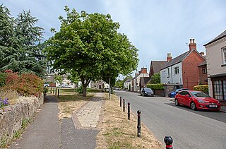
Markfield is a large village in both the National Forest and Charnwood Forest and in the Hinckley and Bosworth district of Leicestershire, England. The settlement dates back to at least the time of the Norman conquest and is mentioned in Domesday Book under the name Merchenefeld. A variant of this is still used as the name for the village primary school, Mercenfeld. It is to the south-east of Junction 22 of the M1, and to the south of the A50. The highest point in Markfield is shown on OS sheet 129 at 222 metres above sea level. Nearby places are Newtown Linford, Groby, Field Head, and Stanton under Bardon. In the 1841 census its population was recorded at 1,203. In the 2011 census the parish had a population of 5681. In 2012 Hinckley & Bosworth Borough Council published an overview of the Markfield conservation area.

Goldington is part of Bedford, Bedfordshire, England. It encompasses much of the historic village and parish of Goldington that was merged with Bedford in 1934, although some parts of the old village are within the neighbouring Newnham ward. It also includes two modern estates that are part of Renhold parish.
Castle is an electoral ward and area of Bedford, Bedfordshire, England.
The following is a timeline of the history of the city of Leicester, the county town of Leicestershire, in England.

Clarendon is the name given to the ward and suburb of Hinckley in the Hinckley & Bosworth district in the county of Leicestershire, England. It is one of the six wards on Hinckley and Bosworth Borough Council of the town.

Burbage St Catherines and Lash Hill is the name given to the ward and suburb of Hinckley in the Hinckley & Bosworth district in the county of Leicestershire, England. It is one of the six wards on Hinckley and Bosworth Borough Council of the town. The ward is one of two of Burbage and covers the suburbs of Lash Hill and St Catherine's.

Burbage Sketchley and Stretton is the name given to the ward and suburb of Hinckley in the Hinckley & Bosworth district in the county of Leicestershire, England. It is one of the six wards on Hinckley and Bosworth Borough Council of the town. The ward is one of two of Burbage and covers the settlement of Leicester Grange and the suburbs of Sketchley, Stretton and Tilton.

Sketchley is a former village and one of the five wards of the village of Burbage in the Hinckley & Bosworth borough of the ceremonial county of Leicestershire, England. It takes its name from the former village that also included a hall and church. It is now a suburb of the larger Burbage/Hinckley urban area.

St Catherine's is one of the five wards of the village of Burbage and covers the older centre of the village. It takes its name from the nearby parish church of St Catherine's.


