
Harvard Square is a triangular plaza at the intersection of Massachusetts Avenue, Brattle Street and John F. Kennedy Street near the center of Cambridge, Massachusetts, United States. The term "Harvard Square" is also used to delineate the business district and Harvard University surrounding that intersection, which is the historic center of Cambridge. Adjacent to Harvard Yard, the historic heart of Harvard University, the Square functions as a commercial center for Harvard students, as well as residents of western Cambridge, the western and northern neighborhoods and the inner suburbs of Boston. The Square is served by Harvard station, a major MBTA Red Line subway and a bus transportation hub.

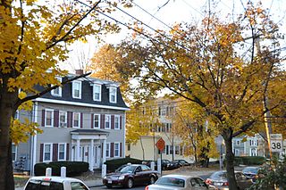
Central Square is an area in Cambridge, Massachusetts centered on the junction of Massachusetts Avenue, Prospect Street and Western Avenue. Lafayette Square, formed by the junction of Massachusetts Avenue, Columbia Street, Sidney Street and Main Street, is also considered a part of the Central Square area. Harvard Square is to the northwest along Massachusetts Avenue, Inman Square is to the north along Prospect Street and Kendall Square is to the east along Main Street. The section of Central Square along Massachusetts Avenue between Clinton Street and Main Street is designated the Central Square Historic District, and was added to the National Register of Historic Places in 1990.

Central Square is a section of the neighborhood of East Boston in Boston, Massachusetts, United States. The square begins at the intersection of Bennington Street and Meridian Street, continues up Meridian to its intersection with White Street, and includes all the area to the left. The square's intersecting streets also include Border, Saratoga, and Eutaw Street. It is within close proximity of the entrance to the Sumner Tunnel, which motorists take to downtown Boston.

The Codman Square District is a historic district in the Dorchester neighborhood of Boston, Massachusetts. It consists of four of the most prominent properties facing the main Codman Square intersection, where Talbot Avenue and Washington Street cross. The area has a long history as a major civic center in Dorchester, and is now one of the large neighborhood's major commercial hubs. The properties in the district include the 1806 Congregational Church, the 1904 Codman Square branch of the Boston Public Library, the former Girls Latin Academy building, and the Lithgow Building, a commercial brick structure at the southeast corner of the junction that was built in 1899.

Custom House District is a historic district in Boston, Massachusetts, located between the Fitzgerald Expressway and Kilby Street and South Market and High and Batterymarch Streets. Named after the 1849 Boston Custom House located on State Street, the historic district contains about seventy buildings on nearly sixteen acres in Downtown Boston, consisting of 19th-century mercantile buildings along with many early 20th-century skyscrapers, including the 1915 Custom House Tower.

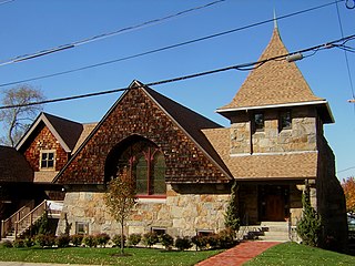
The First Baptist Church is a historic American Baptist church at Magazine and River Street in Cambridge, Massachusetts within Central Square. In 1817 the church congregation was founded in the home of James Hovey. In 1844 several members of First Baptist Church left to found nearby Old Cambridge Baptist Church. First Baptist Church's current Gothic building was constructed in 1881 to a design by Hartwell and Richardson. It was added to the National Register of Historic Places in 1975.

The Monument Square–Eagle Street Historic District is a historic district encompassing the civic heart of North Adams, Massachusetts. When it was originally designated in 1972, the district encompassed Monument Square – west of the intersection of Main Street and Church Street, and the location of a Civil War memorial – and the area around it. This designation included the North Adams Public Library, the First Baptist Church and First Congregational Church, and a block of shops Eagle Street. In 1988, the district's boundaries were increased to be roughly bounded by Holden, Center and Union Streets, the East Middle School, Summer Street, and Main Street. This expansion extended the district westward along Summer Street to include the US Post Office building and St. John's Church, and eastward to include Colgrove Park, the middle school, and St. Francis Catholic Church. An additional block of commercial buildings was also added on the north side of West Main Street, extending just west of Holden Street.

The Musgrove Block is a historic commercial building at 2 Main Street in the center of Andover, Massachusetts. The three-story brick building was built in 1895 on the site of a former town green, and forms part of Andover's central Elm Square intersection. The building exhibits Romanesque Revival styling, featuring granite trim elements and ornate brick detailing. It was listed on the National Register of Historic Places in 1982.

The US Post Office–Medford Main is a historic post office at 20 Forest Street in Medford, Massachusetts. Built in 1937, it is a fine example of construction work funded by the Public Works Administration, a jobs program of the 1930s. It was listed on the National Register of Historic Places in 1986.
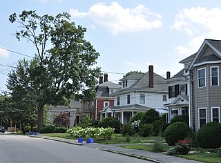
The Washington Square Historic District of Lowell, Massachusetts encompasses a historic subdivision laid out in 1832. The focal point of the subdivision is Kittridge Park, which lies on the eastern side of the district and was an original part of the subdivision plan developed by the Nesmith Brothers. It was the first significant residential subdivision in the city aimed at a wealthier clientele, and was designed by landscape architect Alexander Wadsworth. The district was added to the National Register of Historic Places in 1982, and expanded slightly in 1999.
The Wollaston Unitarian Church, more recently a former home of the St. Catherine's Greek Orthodox Church, is a historic church building at 155 Beale Street in Quincy, Massachusetts. Built in 1888 to a design by Edwin J. Lewis Jr., it is a prominent local example of Shingle Style architecture. It was added to the National Register of Historic Places in 1989. The building has been converted to residential use.

The Central Square Historic District is a historic district encompassing much of the central business district of Stoneham, Massachusetts. It includes the town's largest concentration of 19th and early-20th century commercial architecture, in an area that developed in importance as a commercial center after the construction of the Andover-Medford Turnpike. The district was added to the National Register of Historic Places in 1990.
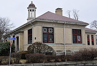
The Stoneham Public Library is the public library of Stoneham, Massachusetts. It is located at Main and Maple Streets.
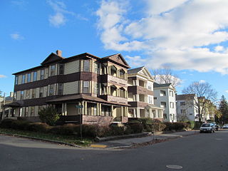
The Houghton Street Historic District is a historic district in Worcester, Massachusetts. It consists of seven triple-decker residences and three period garages, all built between 1920 and 1926. The buildings represent a well-preserved and cohesive collection of Colonial Revival residences. The district was listed on the National Register of Historic Places in 1990. Some of the buildings have lost historic integrity since the listing.
The Lyman Street Historic District is a historic district roughly encompassing Lyman Street between Church and Main Streets in Waltham, Massachusetts. Lyman Street was laid out in 1826 by Theodore Lyman, owner of The Vale, a country estate just to the north. Residential development took place along the street roughly between 1840 and 1900, resulting in a series of fashionable houses in a variety of 19th century architectural styles on the west side of the street. The district was listed on the National Register of Historic Places in 1989.

The Hollis Village Historic District encompasses the historic village center of Hollis, New Hampshire. The district is centered on Monument Square, which connects Main Street to Depot Street and Broad Street. It covers about 400 acres (160 ha), and extends along all three of those roads for some distance, and includes properties on Silver Lake Road and Ash Street. Most of the buildings in the district are residential or agricultural in use, and date before the turn of the 20th century; the oldest buildings date to the mid-18th century. The "Always Ready Engine House", which occupies a triangular parcel at the western end of Monument Square, was built in 1859, and is the town's oldest municipal building. Its most architecturally sophisticated building is the town hall, built in 1887 to a design by William M. Butterfield of Manchester. The district represents the growth of a mainly agricultural community over a 200-year period. The district was listed on the National Register of Historic Places in 2001.

Mount Vernon Triangle is a neighborhood and community improvement district in the northwest quadrant of Washington, D.C. The neighborhood is located adjacent to Mount Vernon Square. Originally a working-class neighborhood established in the 19th century, present-day Mount Vernon Triangle experienced a decline in the mid-20th century as it transitioned from residential to commercial and industrial use.

Fort Hill is a 0.4 square mile neighborhood and historic district of Roxbury, in Boston, Massachusetts. The approximate boundaries of Fort Hill are Malcolm X Boulevard on the north, Washington Street on the southeast, and Columbus Avenue on the southwest.

The Market Square Historic District of Houlton, Maine encompasses that town's historic late-19th century central business district. Centered on the junction of Market Square, Court Street, Water Street, and Main Street, it includes a relatively cohesive assortment of brick and masonry commercial buildings, designed by architects and built between 1885 and 1910, following the arrival of the Bangor and Aroostook Railroad. The district was listed on the National Register of Historic Places in 1980.
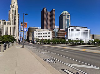
Broad Street is a major thoroughfare in Central Ohio, predominantly in Franklin County and Columbus. It stretches east from West Jefferson at Little Darby Creek to Pataskala. The street is considered one of Columbus's two main roads, along with High Street.


