Chestline, Illinois | |
|---|---|
 Chestline, Illinois  Chestline, Illinois | |
| Coordinates: 39°50′41″N90°57′35″W / 39.84472°N 90.95972°W | |
| Country | United States |
| State | Illinois |
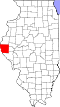
| County | Adams |
| Elevation | 715 ft (218 m) |
| Time zone | UTC-6 (Central (CST)) |
| • Summer (DST) | UTC-5 (CDT) |
| Area code | 217 |
| GNIS feature ID | 422546 [1] |
Chestline is an unincorporated community in Beverly and McKee Township Townships, Adams County, Illinois, United States. Chestline is southeast of Liberty.
A post office called Chestline was established in 1882, and remained in operation until 1906. [2] According to tradition, a grove of chestnut trees near the original town site accounts for the name. [3]