Kingston, Illinois | |
|---|---|
 Kingston, Illinois  Kingston, Illinois | |
| Coordinates: 39°49′10″N91°01′37″W / 39.81944°N 91.02694°W [1] | |
| Country | United States |
| State | Illinois |
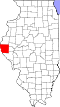
| County | Adams |
| Township | Beverly and Richfield townships |
| Area | |
• Total | 0.21 sq mi (0.55 km2) |
| • Land | 0.21 sq mi (0.55 km2) |
| • Water | 0 sq mi (0.00 km2) |
| Elevation | 801 ft (244 m) |
| Population (2020) | |
• Total | 20 |
| • Density | 94.0/sq mi (36.28/km2) |
| Time zone | UTC-6 (Central (CST)) |
| • Summer (DST) | UTC-5 (CDT) |
| Area code | 217 |
| FIPS code | 17-40052 |
| GNIS feature ID | 2804086 [1] |
Kingston is an unincorporated community and census-designated place in Beverly and Richfield Townships, Adams County, Illinois, United States. Kingston is located along Illinois Route 104 southeast of Liberty.