Marcelline, Illinois | |
|---|---|
 Marcelline, Illinois  Marcelline, Illinois | |
| Coordinates: 40°07′07″N91°22′06″W / 40.11861°N 91.36833°W [1] | |
| Country | United States |
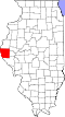
| State | Illinois |
| County | Adams |
| Area | |
• Total | 0.050 sq mi (0.13 km2) |
| • Land | 0.050 sq mi (0.13 km2) |
| • Water | 0 sq mi (0.00 km2) |
| Elevation | 617 ft (188 m) |
| Population (2020) | |
• Total | 75 |
| • Density | 1,508.6/sq mi (582.48/km2) |
| Time zone | UTC-6 (Central (CST)) |
| • Summer (DST) | UTC-5 (CDT) |
| Area code | 217 |
| GNIS feature ID | 2804087 [1] |
Marcelline is an unincorporated community and census designated place (CDP) in northwest Ursa Township, Adams County, Illinois, United States.
Marcelline is located on Illinois Route 96 four miles north of Ursa and five miles south of Lima. Bear Creek flows past approximately two miles to the north. [3]