Richfield, Illinois | |
|---|---|
 Richfield, Illinois  Richfield, Illinois | |
| Coordinates: 39°48′58″N91°07′14″W / 39.81611°N 91.12056°W [1] | |
| Country | United States |
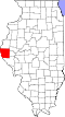
| State | Illinois |
| County | Adams |
| Area | |
• Total | 0.47 sq mi (1.21 km2) |
| • Land | 0.47 sq mi (1.21 km2) |
| • Water | 0 sq mi (0.00 km2) |
| Elevation | 722 ft (220 m) |
| Population (2020) | |
• Total | 26 |
| • Density | 55.6/sq mi (21.48/km2) |
| Time zone | UTC-6 (Central (CST)) |
| • Summer (DST) | UTC-5 (CDT) |
| Area code | 217 |
| GNIS feature ID | 2804090 [1] |
Richfield is an unincorporated community in Richfield Township, Adams County, Illinois, United States. Richfield is east of Payson.