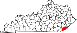
Chevrolet, Kentucky

Last updated

Chevrolet, Kentucky
USA Kentucky location map.svg
Red pog.svg
Chevrolet
Usa edcp location map.svg
Red pog.svg
Chevrolet
Coordinates: 36°49′2″N83°16′29″W / 36.81722°N 83.27472°W / 36.81722; -83.27472
Country United States
State Kentucky
County Harlan
Elevation
1,325 ft (404 m)
Time zone UTC-6 (Central (EST))
  Summer (DST) UTC-5 (EST)
ZIP codes
40817 [1]
GNIS feature ID489465 [2]

Chevrolet is an unincorporated community in Harlan County, Kentucky, United States.

History

A post office called Chevrolet was established in 1918, and remained in operation until 1992. [3] The community was named after the Chevrolet Series 490, the first car seen on local roads. [4]

A 1935 newspaper account reported the town had 800 inhabitants, and about 60 cars, 30 of which were Chevrolets. [5]

References

  1. "Postmaster Finder - Who We Are - USPS".
  2. U.S. Geological Survey Geographic Names Information System: Chevrolet, Kentucky
  3. "Post Offices". Jim Forte Postal History. Retrieved January 5, 2017.
  4. Rennick, Robert M. (1987). Kentucky Place Names. University Press of Kentucky. p. 57. ISBN   0813126312 . Retrieved April 28, 2013.
  5. "Town named after Chevrolets, first auto on streets". The Victoria Advocate. July 26, 1935. p. 5. Retrieved August 18, 2015.