
Antoine-Labelle is a regional county municipality located in the Laurentides region of Quebec, Canada. Its seat is Mont-Laurier. It is named for Antoine Labelle.

Saint-Jérôme is a suburban city located about 45 kilometres (28 mi) northwest of Montreal on the Rivière du Nord. It is part of the North Shore sector of Greater Montreal. It is a gateway to the Laurentian Mountains and its resorts via the Autoroute des Laurentides.
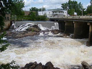
Mont-Laurier is a town and incorporated municipality in northwest Quebec, Canada, located on the banks of the Lièvre River, a tributary of the Ottawa River. Known as the "Capital of the Haute-Laurentides", the motto of the town is Laurus elationis praemium, which translates to "Lift the laurels of reward". The demonym for its inhabitants is Lauriermontois.

Stoneham-et-Tewkesbury is a united township municipality in the Canadian province of Quebec, located in the regional county municipality of La Jacques-Cartier north of Quebec City. Its main attraction is the Stoneham Mountain Resort.

Trois-Rives is a municipality with an area of 675 square kilometres (261 sq mi) located in Mékinac Regional County Municipality, in the Mid-Mauricie, province of Quebec, Canada.

Duhamel is a town and municipality in the Outaouais region of Quebec, Canada. It is the largest municipality in surface area in the Papineau Regional County Municipality.

Saint-André-d'Argenteuil is a municipality in the Laurentides region of Quebec, Canada, part of the Argenteuil Regional County Municipality. It is located along the Ottawa River, just south of Lachute.

Sainte-Anne-du-Lac is a municipality and village in the Laurentides region of Quebec, Canada, part of the Antoine-Labelle Regional County Municipality.

Lac-Tremblant-Nord is a small village and municipality in the Laurentides region of Quebec, Canada, part of the Les Laurentides Regional County Municipality. Its territory surrounds the northern portion of Lake Tremblant, includes Bibite Lake, and extends to Gervais Lake. The village is located on the south shore of the Lake Tremblant, a few kilometres west of the Mont Tremblant Resort.

Labelle is a village and municipality in the Laurentides region of Quebec, Canada, part of the Les Laurentides Regional County Municipality. Its large L-shaped territory surrounds Lake Labelle, and the village is located along the Rouge River and Route 117.

La Minerve is a village and municipality in the Laurentides region of Quebec, Canada, part of the Les Laurentides Regional County Municipality.

Notre-Dame-du-Laus is a municipality in the Laurentides region of Quebec, Canada, part of the Antoine-Labelle Regional County Municipality.

Saint-Aimé-du-Lac-des-Îles is a municipality in the Laurentides region of Quebec, Canada, part of the Antoine-Labelle Regional County Municipality.

Lac-des-Écorces is a municipality and village in the Laurentides region of Quebec, Canada, part of the Antoine-Labelle Regional County Municipality.

Lac-Saguay is a village municipality in Antoine-Labelle Regional County Municipality in the Laurentides region of Quebec, Canada.
Lac-Saint-Paul is a municipality in the Laurentides region of Quebec, Canada, part of the Antoine-Labelle Regional County Municipality.

Mont-Saint-Michel is a municipality in the Laurentides region of Quebec, Canada, part of the Antoine-Labelle Regional County Municipality.

Ferme-Neuve is a municipality part of the Antoine-Labelle Regional County Municipality, in the Laurentides region of Quebec, Canada. It is the largest incorporated municipality of the Laurentides region.
L'Ascension is a municipality in the Laurentides region of Quebec, Canada, part of the Antoine-Labelle Regional County Municipality. The area is known as La Vallée de la Rouge.

Baie-des-Chaloupes is an unorganized territory of Quebec located in the regional county municipality of Antoine-Labelle, in Laurentides, in Québec, in Canada. It covers a land area of 900 km.


