Ferme-Neuve

Last updated

Ferme-Neuve
Eglise de Ferme-Neuve.JPG
The Roman Catholic church in Ferme-Neuve
Motto: 
Non nova sed nove (English: "Not new but in a new way")
Ferme-Neuve Quebec location diagram.png
Location within Antoine-Labelle RCM
Canada Central Quebec location map.png
Red pog.svg
Ferme-Neuve
Location in central Quebec
Coordinates: 46°42′N75°27′W / 46.700°N 75.450°W / 46.700; -75.450 [1]
Country Canada
Province Quebec
Region Laurentides
RCM Antoine-Labelle
Settled1890s
ConstitutedDecember 24, 1997
Government
[2]
  MayorDiane Sirard
   Federal riding Laurentides—Labelle
   Prov. riding Labelle
Area
  Total875.10 km2 (337.88 sq mi)
  Land790.29 km2 (305.13 sq mi)
Population
 (2021) [3]
  Total2,716
  Density3.5/km2 (9/sq mi)
  Pop. 2016-2021
Increase2.svg 0.4%
  Dwellings
1,453
Time zone UTC−5 (EST)
  Summer (DST) UTC−4 (EDT)
Postal code(s)
Area code 819
HighwaysQc309.svg R-309
Website www.municipalite.ferme-neuve.qc.ca OOjs UI icon edit-ltr-progressive.svg

Ferme-Neuve (French for "New Farm") is a municipality part of the Antoine-Labelle Regional County Municipality, in the Laurentides region of Quebec, Canada. It is the largest incorporated municipality of the Laurentides region.

Contents

The village is located on the shores of the Du Lièvre River and Journalists Lake, and along Quebec Route 309, about 20 kilometres (12 mi) north of Mont-Laurier.

History

In the 19th century, the area began attracting loggers because of its rich red and white pine stands. In 1850, the James MacLaren logging company built a large tree farm called "La Ferme de la Montagne" that was used as a supply camp for loggers. It was sold in 1888 to Cyrille Lafontaine and inhabited by his son Léonard who became the first settler and farmer of Ferme-Neuve. [4] In 1898, the Ferme-Neuve Post Office opened. [1]

In 1902, a group of 8 Montreal journalists, under direction from Lomer Gouin, Minister of Colonization, built a model farm in order to attract more settlers. They also launched a public subscription to build a school. In recognition, the lake adjacent to the settlement was called Lac des Journalistes ("Lake of Journalists"). [1]

Also in 1902, the United Township Municipality of Würtele-Moreau-et-Gravel was formed, with Toussaint Cloutier as first mayor. In 1917, the Ferme-Neuve settlement separated from the united township and became an incorporated village, with Henri Berthiaume as its first mayor. In 1930, the United Township Municipality of Würtele-Moreau-et-Gravel changed statutes and was renamed to the Parish Municipality of Ferme-Neuve. [1] [4]

On December 24, 1997, both entities were merged again into the new Municipality of Ferme-Neuve.

Demographics

Canada census – Ferme-Neuve community profile
2021 2016
Population2,716 (+0.4% from 2016)2,706 (-4.1% from 2011)
Land area786.19 km2 (303.55 sq mi)793.44 km2 (306.35 sq mi)
Population density3.5/km2 (9.1/sq mi)3.4/km2 (8.8/sq mi)
Median age53.2 (M: 52.4, F: 54.4)50.7 (M: 49.8, F: 51.4)
Private dwellings1,453 (total)  1,276 (occupied)1,388 (total) 
Median household income$55,600$48,480
References: 2021 [5] 2016 [6] earlier [7] [8]
Historical census populations – Ferme-Neuve
YearPop.±%
1976 2,938    
1981 3,118+6.1%
1986 3,025−3.0%
1991 3,174+4.9%
1996 3,091−2.6%
YearPop.±%
2001 2,947−4.7%
2006 3,006+2.0%
2011 2,822−6.1%
2016 2,706−4.1%
2021 2,716+0.4%
Population amounts prior to 1997 are total of Ferme-Neuve (Village) and Ferme-Neuve (Parish).
Source: Statistics Canada

Population trend (prior to amalgamation):

Private dwellings occupied by usual residents: 1,276 (total dwellings: 1,453) [3]

Mother tongue:

Local government

List of former mayors:

See also

Related Research Articles

<span class="mw-page-title-main">L'Isle-aux-Allumettes</span> Municipality in Quebec, Canada

L'Isle-aux-Allumettes is a municipality in the Outaouais region, part of the Pontiac Regional County Municipality, Quebec, Canada. The municipality consists primarily of Allumette Island, and also includes Morrison Island, Marcotte Island, and some minor islets, all in the Ottawa River north of Pembroke.

<span class="mw-page-title-main">Wentworth, Quebec</span> Township municipality in Quebec, Canada

Wentworth is a township municipality in the Laurentides region of Quebec, Canada, part of the Argenteuil Regional County Municipality, north-west of Lachute.

<span class="mw-page-title-main">Egan-Sud, Quebec</span> Municipality in Quebec, Canada

Egan-Sud is a municipality in the La Vallée-de-la-Gatineau Regional County Municipality, Quebec, Canada, directly north of Maniwaki.

<span class="mw-page-title-main">Montpellier, Quebec</span> Municipality in Quebec, Canada

Montpellier is a town and municipality in the Papineau Regional County Municipality in the Outaouais region of Quebec, Canada. The town is located 30 kilometres (19 mi) northwest of Papineauville.

<span class="mw-page-title-main">Lac-Simon, Outaouais</span> Municipality in Quebec, Canada

Lac-Simon is a town and municipality in the Outaouais region of Quebec, Canada, part of the Papineau Regional County Municipality.

<span class="mw-page-title-main">Namur, Quebec</span> Municipality in Quebec, Canada

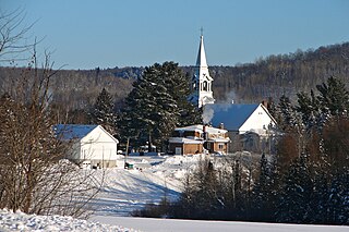
Namur is a town and municipality in the Outaouais region of Quebec, Canada, part of the Papineau Regional County Municipality. It is nicknamed "la Nouvelle Belgique".

<span class="mw-page-title-main">Saint-André-d'Argenteuil</span> Municipality in Quebec, Canada

Saint-André-d'Argenteuil is a municipality in the Laurentides region of Quebec, Canada, part of the Argenteuil Regional County Municipality. It is located along the Ottawa River, just south of Lachute.

<span class="mw-page-title-main">Sainte-Anne-du-Lac</span> Municipality in Quebec, Canada

Sainte-Anne-du-Lac is a municipality and village in the Laurentides region of Quebec, Canada, part of the Antoine-Labelle Regional County Municipality.

<span class="mw-page-title-main">La Minerve, Quebec</span> Municipality in Quebec, Canada

La Minerve is a village and municipality in the Laurentides region of Quebec, Canada, part of the Les Laurentides Regional County Municipality.

<span class="mw-page-title-main">Notre-Dame-du-Laus</span> Municipality in Quebec, Canada

Notre-Dame-du-Laus is a municipality in the Laurentides region of Quebec, Canada, part of the Antoine-Labelle Regional County Municipality.

<span class="mw-page-title-main">Notre-Dame-de-Pontmain</span> Municipality in Quebec, Canada

Notre-Dame-de-Pontmain is a municipality in the Laurentides region of Quebec, Canada, part of the Antoine-Labelle Regional County Municipality.

<span class="mw-page-title-main">Saint-Aimé-du-Lac-des-Îles</span> Municipality in Quebec, Canada

Saint-Aimé-du-Lac-des-Îles is a municipality in the Laurentides region of Quebec, Canada, part of the Antoine-Labelle Regional County Municipality.

<span class="mw-page-title-main">Kiamika, Quebec</span> Municipality in Quebec, Canada

Kiamika is a municipality in the Laurentides region of Quebec, Canada, part of the Antoine-Labelle Regional County Municipality.

<span class="mw-page-title-main">Lac-des-Écorces, Quebec</span> Municipality in Quebec, Canada

Lac-des-Écorces is a municipality and village in the Laurentides region of Quebec, Canada, part of the Antoine-Labelle Regional County Municipality.

<span class="mw-page-title-main">Lac-Saguay</span> Village municipality in Quebec, Canada

Lac-Saguay is a village municipality in Antoine-Labelle Regional County Municipality in the Laurentides region of Quebec, Canada.

<span class="mw-page-title-main">Chute-Saint-Philippe</span> Municipality in Quebec, Canada

Chute-Saint-Philippe is a municipality in the Laurentides region of Quebec, Canada, part of the Antoine-Labelle Regional County Municipality.

<span class="mw-page-title-main">Lac-Saint-Paul, Quebec</span> Municipality in Quebec, Canada

Lac-Saint-Paul is a municipality in the Laurentides region of Quebec, Canada, part of the Antoine-Labelle Regional County Municipality.

<span class="mw-page-title-main">Mont-Saint-Michel, Quebec</span> Municipality in Quebec, Canada

Mont-Saint-Michel is a municipality in the Laurentides region of Quebec, Canada, part of the Antoine-Labelle Regional County Municipality.

<span class="mw-page-title-main">L'Ascension, Quebec</span> Municipality in Quebec, Canada

L'Ascension is a municipality in the Laurentides region of Quebec, Canada, part of the Antoine-Labelle Regional County Municipality. The area is known as La Vallée de la Rouge.

<span class="mw-page-title-main">Escuminac, Quebec</span> Municipality in Quebec, Canada

Escuminac is a municipality in Quebec, Canada, on the north shore of the Restigouche River.

References

  1. 1 2 3 4 "Ferme-Neuve (Municipalité)" (in French). Commission de toponymie du Québec. Retrieved 2009-08-31.
  2. 1 2 "Geographic code 79097 in the official Répertoire des municipalités". www.mamh.gouv.qc.ca (in French). Ministère des Affaires municipales et de l'Habitation.
  3. 1 2 3 "Ferme-Neuve, Municipalité (MÉ) Census Profile, 2021 Census of Population". www12.statcan.gc.ca. Government of Canada - Statistics Canada. Retrieved 27 June 2022.
  4. 1 2 "Histoire et patrimoine" (in French). Municipalité de Ferme-Neuve. Archived from the original on 2009-02-23. Retrieved 2009-08-31.
  5. "2021 Community Profiles". 2021 Canadian Census . Statistics Canada. February 4, 2022. Retrieved 2023-10-19.
  6. "2016 Community Profiles". 2016 Canadian Census . Statistics Canada. August 12, 2021. Retrieved 2022-06-27.
  7. "2006 Community Profiles". 2006 Canadian Census . Statistics Canada. August 20, 2019.
  8. "2001 Community Profiles". 2001 Canadian Census . Statistics Canada. July 18, 2021.

Commons-logo.svg Media related to Ferme-Neuve, Quebec at Wikimedia Commons