Notre-Dame-de-Pontmain

Last updated
Notre-Dame-de-Pontmain
Pontmain vu de la Montagne.jpg
Notre-Dame-de-Pontmain Quebec location diagram.png
Location within Antoine-Labelle RCM
Canada Central Quebec location map.png
Red pog.svg
Notre-Dame-de-Pontmain
Location in central Quebec
Coordinates: 46°17′N75°38′W / 46.283°N 75.633°W / 46.283; -75.633 Coordinates: 46°17′N75°38′W / 46.283°N 75.633°W / 46.283; -75.633 [1]
Country Canada
Province Quebec
Region Laurentides
RCM Antoine-Labelle
ConstitutedJanuary 26, 1894
Government
[2]
  MayorLyz Beaulieu
   Federal riding Laurentides—Labelle
   Prov. riding Labelle
Area
  Total307.74 km2 (118.82 sq mi)
  Land259.90 km2 (100.35 sq mi)
Population
 (2021) [3]
  Total790
  Density3.0/km2 (8/sq mi)
  Pop. 2016-2021
Increase2.svg 1.0%
  Dwellings
746
Time zone UTC−5 (EST)
  Summer (DST) UTC−4 (EDT)
Postal code(s)
Area code(s) 819
HighwaysQc309.svg Route 309
Qc311.svg Route 311
Website www.munpontmain.qc.ca OOjs UI icon edit-ltr-progressive.svg

Notre-Dame-de-Pontmain is a municipality in the Laurentides region of Quebec, Canada, part of the Antoine-Labelle Regional County Municipality.

Contents

The village itself is located between Camp and Dudley Lakes in the Lièvre River watershed.

History

European colonization began when logging companies started to exploit the forests of the Du Lièvre River in the second half of the 19th century. By 1881, there were 35 families in the village. [4]

In 1884, the local parish was formed which extended over the territory of Wabassee, Dudley, and Bouthillier geographic townships. The first pastor, Eugene Trinquier, serving from 1886 to 1907, was originally from Gap in the Hautes-Alpes (France) and named the parish Notre-Dame-de-Pontmain, after the apparitions of Our Lady of Pontmain. [1]

On January 26, 1894, the Municipal Corporation of the United Townships of Wabassee-Dudley-et-Bouthillier was formed, becoming one of the oldest municipalities in the regional county. In 1897, its first bridge was built. In 1898, the first school opened, followed by the first general store in 1900, and the sawmill in 1902. [4]

In 1945, it was renamed to Notre-Dame-de-Pontmain. [1]

Demographics

Canada census – Notre-Dame-de-Pontmain community profile
2021 2016
Population790 (+1.0% from 2016)782 (+8.6% from 2011)
Land area259.90 km2 (100.35 sq mi)263.48 km2 (101.73 sq mi)
Population density3.0/km2 (7.8/sq mi)3.0/km2 (7.8/sq mi)
Median age62.4 (M: 63.2, F: 61.2)59.1 (M: 60.4, F: 58.4)
Total private dwellings746776
Median household income$49,237
References: 2021 [5] 2016 [6] earlier [7] [8]
Historical census populations – Notre-Dame-de-Pontmain
YearPop.±%
1976 446    
1981 487+9.2%
1986 533+9.4%
1991 547+2.6%
1996 581+6.2%
YearPop.±%
2001 620+6.7%
2006 712+14.8%
2011 720+1.1%
2016 782+8.6%
2021 790+1.0%
Source: Statistics Canada

Private dwellings occupied by usual residents (2021): 411 (total dwellings: 746) [3]

Mother tongue:

See also

Related Research Articles

Notre-Dame-des-Anges, Quebec Parish municipality in Quebec, Canada

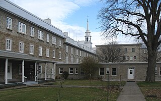
Notre-Dame-des-Anges is a parish municipality in Quebec, Canada, home of the General Hospital of Quebec.

Notre-Dame-de-Montauban Municipality in Quebec, Canada

Notre-Dame-de-Montauban is a municipality in the Mauricie region in Canada. This municipality is located at the northern edge of regional county municipality of Mékinac Regional County Municipality and the administrative region of Mauricie. It includes the population centres of Notre-Dame-des-Anges and Montauban-les-Mines. Both communities are located along route 367, about 7 kilometres (4.3 mi) apart.

Notre-Dame-du-Nord Municipality in Quebec, Canada

Notre-Dame-du-Nord is a municipality in the Canadian province of Quebec, located in the Témiscamingue Regional County Municipality. It is located at the northern end of Lake Timiskaming where the Ottawa River enters into this lake.

LAnge-Gardien, Outaouais, Quebec Municipality in Quebec, Canada

L'Ange-Gardien is a municipality in the Outaouais region of Quebec, Canada. It constitutes the easternmost part of Les Collines-de-l'Outaouais Regional County Municipality, north of the Buckingham Sector of the City of Gatineau.

Notre-Dame-de-la-Salette, Quebec Municipality in Quebec, Canada

Notre-Dame-de-la-Salette is a municipality in the Outaouais region of Quebec, Canada. It is part of the Papineau Regional County Municipality, straddling the eastern banks of the Du Lièvre River.

Notre-Dame-de-Bonsecours, Quebec Municipality in Quebec, Canada

Notre-Dame-de-Bonsecours is a municipality in the Outaouais region of Quebec, Canada. It is located along the Ottawa River, about 55 kilometres (34 mi) east of Gatineau. It was formerly known as Notre-Dame-de-Bon-Secours-Partie-Nord. It is the least populated municipality in the Papineau Regional County Municipality.

Val-des-Bois, Quebec Municipality in Quebec, Canada

Val-des-Bois is a town and municipality in the Papineau Regional County Municipality in the Outaouais region of Quebec, Canada. The town is located on the eastern shores of the Du Lièvre River, 47 kilometers (29 mi) north of Buckingham.

Notre-Dame-de-la-Paix, Quebec Municipality in Quebec, Canada

Notre-Dame-de-la-Paix is a town and municipality in the Outaouais region of Quebec, Canada, part of the Papineau Regional County Municipality.

La Macaza Municipality in Quebec, Canada

La Macaza is a municipality and village in the province of Quebec, Canada. The village is located in the Laurentian Mountains, in the Laurentian region, in Antoine-Labelle Regional County Municipality. Its population was 1094 in the 2021 Canadian census.

Notre-Dame-du-Laus Municipality in Quebec, Canada

Notre-Dame-du-Laus is a municipality in the Laurentides region of Quebec, Canada, part of the Antoine-Labelle Regional County Municipality.

Lac-du-Cerf Municipality in Quebec, Canada

Lac-du-Cerf is a municipality in the Laurentides region of Quebec, Canada, part of the Antoine-Labelle Regional County Municipality. It is located on and named after Lac du Cerf.

Saint-Aimé-du-Lac-des-Îles Municipality in Quebec, Canada

Saint-Aimé-du-Lac-des-Îles is a municipality in the Laurentides region of Quebec, Canada, part of the Antoine-Labelle Regional County Municipality.

Kiamika, Quebec Municipality in Quebec, Canada

Kiamika is a municipality in the Laurentides region of Quebec, Canada, part of the Antoine-Labelle Regional County Municipality.

Mont-Saint-Michel, Quebec Municipality in Quebec, Canada

Mont-Saint-Michel is a municipality in the Laurentides region of Quebec, Canada, part of the Antoine-Labelle Regional County Municipality.

Ferme-Neuve Municipality in Quebec, Canada

Ferme-Neuve is a municipality part of the Antoine-Labelle Regional County Municipality, in the Laurentides region of Quebec, Canada. It is the largest incorporated municipality of the Laurentides region.

Saint-Ambroise-de-Kildare, Quebec Municipality in Quebec, Canada

Saint-Ambroise-de-Kildare is a municipality in the Lanaudière region of Quebec, Canada, part of the Joliette Regional County Municipality.

Entrelacs, Quebec Municipality in Quebec, Canada

Entrelacs is a municipality in Matawinie Regional County Municipality in the Lanaudière region of Quebec, Canada.

La Doré, Quebec Parish municipality in Quebec, Canada

La Doré is a parish municipality in Quebec, Canada, in the regional county municipality of Le Domaine-du-Roy and the administrative region of Saguenay–Lac-Saint-Jean.

LAscension-de-Notre-Seigneur, Quebec Parish municipality in Quebec, Canada

L'Ascension-de-Notre-Seigneur is a parish municipality in Quebec, Canada, located within the regional county municipality of Lac-Saint-Jean-Est in the Saguenay-Lac-Saint-Jean region. Its name is French for "the Ascension of Our Lord".

References

  1. 1 2 3 "Notre-Dame-de-Pontmain (Municipalité)" (in French). Commission de toponymie du Québec. Retrieved 2009-08-18.
  2. 1 2 "Geographic code 79010 in the official Répertoire des municipalités". www.mamh.gouv.qc.ca (in French). Ministère des Affaires municipales et de l'Habitation.
  3. 1 2 3 "Notre-Dame-de-Pontmain, Municipalité (MÉ) Census Profile, 2021 Census of Population". www12.statcan.gc.ca. Government of Canada - Statistics Canada. Retrieved 4 July 2022.
  4. 1 2 "Histoire de Notre-Dame-de-Pontmain" (in French). Municipalité de Notre-Dame-de-Pontmain. Retrieved 2009-08-18.
  5. "2021 Community Profiles". 2021 Canadian Census . Statistics Canada. February 4, 2022. Retrieved 2022-07-04.
  6. "2016 Community Profiles". 2016 Canadian Census . Statistics Canada. August 12, 2021. Retrieved 2022-07-04.
  7. "2006 Community Profiles". 2006 Canadian Census . Statistics Canada. August 20, 2019.
  8. "2001 Community Profiles". 2001 Canadian Census . Statistics Canada. July 18, 2021.