Lac-du-Cerf

Last updated

Lac-du-Cerf
Lac-du-Cerf QC 1.JPG
Lac-du-Cerf Quebec location diagram.png
Location within Antoine-Labelle RCM
Canada Central Quebec location map.png
Red pog.svg
Lac-du-Cerf
Location in central Quebec
Coordinates: 46°18′N75°30′W / 46.300°N 75.500°W / 46.300; -75.500 [1]
Country Canada
Province Quebec
Region Laurentides
RCM Antoine-Labelle
ConstitutedJanuary 1, 1955
Government
[2]
  MayorNicolas Pentassuglia
   Federal riding Laurentides—Labelle
   Prov. riding Labelle
Area
  Total94.38 km2 (36.44 sq mi)
  Land71.73 km2 (27.70 sq mi)
Population
 (2021) [3]
  Total445
  Density6.2/km2 (16/sq mi)
  Pop. 2016-2021
Increase2.svg 2.3%
  Dwellings
458
Time zone UTC−5 (EST)
  Summer (DST) UTC−4 (EDT)
Postal code(s)
Area code 819
HighwaysQc311.svg R-311
Website www.lacducerf.ca OOjs UI icon edit-ltr-progressive.svg

Lac-du-Cerf is a municipality in the Laurentides region of Quebec, Canada, part of the Antoine-Labelle Regional County Municipality. It is located on and named after Lac du Cerf (Deer Lake).

Contents

The main economic activities are agriculture, forestry, and tourism. [1]

History

At the beginning of the 20th century, the area was still only visited by trappers and log drivers. In 1915 the first 2 settler families arrived and built their homes on the north shore of Petit Lac-du-Cerf (Little Deer Lake). They were followed by more settlers in 1918. In 1919, two bridges were built over the Lièvre River at Île Longue (Long Island), connecting the new settlement to Notre-Dame-de-Pontmain by road. [4]

The place continued to attract more settlers throughout the 1920s and 30s. [4] In 1939, its post office opened (which closed in 1970). [1]

In January 1955, the Municipality of Lac-du-Cerf was created out of territory ceded from Saint-Aimé-du-Lac-des-Îles and Notre-Dame-de-Pontmain. [1] Its first mayor was Joseph Boismenu, who in 1918, at 22 years of age, moved to Lac-du-Cerf together with his wife. [4]

Demographics

Canada census – Lac-du-Cerf community profile
2021 2016
Population445 (+2.3% from 2016)435 (+4.8% from 2011)
Land area71.73 km2 (27.70 sq mi)73.29 km2 (28.30 sq mi)
Population density6.2/km2 (16/sq mi)5.9/km2 (15/sq mi)
Median age62.8 (M: 64.0, F: 62.4)61.8 (M: 62.1, F: 61.5)
Private dwellings458 (total)  245 (occupied)466 (total) 
Median household income$50,800$40,064
References: 2021 [5] 2016 [6] earlier [7] [8]
Historical census populations – Lac-du-Cerf
YearPop.±%
1976 378    
1981 382+1.1%
1986 371−2.9%
1991 409+10.2%
1996 425+3.9%
YearPop.±%
2001 420−1.2%
2006 424+1.0%
2011 415−2.1%
2016 435+4.8%
2021 445+2.3%
Source: Statistics Canada

Private dwellings occupied by usual residents: 245 (total dwellings: 458) [3]

Mother tongue:

Local government

Municipal Hall of Lac-du-Cerf Lac-du-Cerf QC 2.JPG
Municipal Hall of Lac-du-Cerf

List of former mayors: [4]

See also

Related Research Articles

<span class="mw-page-title-main">Beauharnois-Salaberry Regional County Municipality</span> Regional county municipality in Quebec, Canada

Beauharnois-Salaberry is a regional county municipality in the Montérégie region of Quebec, Canada. Its seat is Beauharnois.

<span class="mw-page-title-main">Sainte-Anne-des-Plaines</span> City in Quebec, Canada

Sainte-Anne-des-Plaines is a city in southwestern Quebec, Canada, 40 km northwest of the city of Montreal in the Thérèse-De Blainville Regional County Municipality, in the region of Laurentides. Its population was 14,990 during the census of 2014.

<span class="mw-page-title-main">Wentworth, Quebec</span> Township municipality in Quebec, Canada

Wentworth is a township municipality in the Laurentides region of Quebec, Canada, part of the Argenteuil Regional County Municipality, north-west of Lachute.

<span class="mw-page-title-main">Cayamant</span> Municipality in Quebec, Canada

Cayamant is a municipality in La Vallée-de-la-Gatineau Regional County Municipality, Quebec, Canada. The village of Lac-Cayamant is located at the north end of Lake Cayamant, west of Gracefield.

<span class="mw-page-title-main">Duhamel, Quebec</span> Municipality in Quebec, Canada

Duhamel is a town and municipality in the Outaouais region of Quebec, Canada. It is the largest municipality in surface area in the Papineau Regional County Municipality.

<span class="mw-page-title-main">Lac-Simon, Outaouais</span> Municipality in Quebec, Canada

Lac-Simon is a town and municipality in the Outaouais region of Quebec, Canada, part of the Papineau Regional County Municipality.

<span class="mw-page-title-main">Namur, Quebec</span> Municipality in Quebec, Canada

Namur is a town and municipality in the Outaouais region of Quebec, Canada, part of the Papineau Regional County Municipality. It is nicknamed "la Nouvelle Belgique".

<span class="mw-page-title-main">Lac-des-Plages, Quebec</span> Municipality in Quebec, Canada

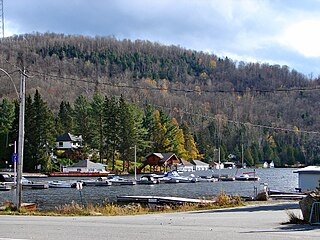
Lac-des-Plages is a town and municipality in the Outaouais region of Quebec, Canada, part of the Papineau Regional County Municipality. It is named after Lac des Plages which attracts many vacationers with the beauty of its beaches.

<span class="mw-page-title-main">Mille-Isles</span> Municipality in Quebec, Canada

Mille-Isles is a municipality in the Laurentides region of Quebec, Canada, part of the Argenteuil Regional County Municipality, west of Saint-Jérôme.

<span class="mw-page-title-main">Saint-Placide, Quebec</span> Municipality in Quebec, Canada

Saint-Placide is a municipality in the Laurentides region of Quebec, Canada, part of the Deux-Montagnes Regional County Municipality, along the north shore of the Ottawa River.

<span class="mw-page-title-main">Saint-Joseph-du-Lac</span> Municipality in Quebec, Canada

Saint-Joseph-du-Lac is a municipality in the Laurentides region of Quebec, Canada, part of the Deux-Montagnes Regional County Municipality.

<span class="mw-page-title-main">Lac-des-Seize-Îles</span> Municipality in Quebec, Canada

Lac-des-Seize-Îles is a village and municipality in the Laurentides region of Quebec, Canada, part of the Les Pays-d'en-Haut Regional County Municipality. The municipality surrounds and is named after Sixteen Island Lake with the village situated at the northern end of this lake.

<span class="mw-page-title-main">Sainte-Anne-du-Lac</span> Municipality in Quebec, Canada

Sainte-Anne-du-Lac is a municipality and village in the Laurentides region of Quebec, Canada, part of the Antoine-Labelle Regional County Municipality.

<span class="mw-page-title-main">Natashquan</span> Municipality in Quebec, Canada

Natashquan is a municipality in Minganie Regional County Municipality, Côte-Nord region, Quebec, Canada. It should not be confused with the adjacent but separate Innu reserve of Nutashkuan.

<span class="mw-page-title-main">Notre-Dame-de-Pontmain</span> Municipality in Quebec, Canada

Notre-Dame-de-Pontmain is a municipality in the Laurentides region of Quebec, Canada, part of the Antoine-Labelle Regional County Municipality.

<span class="mw-page-title-main">Saint-Aimé-du-Lac-des-Îles</span> Municipality in Quebec, Canada

Saint-Aimé-du-Lac-des-Îles is a municipality in the Laurentides region of Quebec, Canada, part of the Antoine-Labelle Regional County Municipality.

<span class="mw-page-title-main">Lac-des-Écorces, Quebec</span> Municipality in Quebec, Canada

Lac-des-Écorces is a municipality and village in the Laurentides region of Quebec, Canada, part of the Antoine-Labelle Regional County Municipality.

<span class="mw-page-title-main">Lac-Saguay</span> Village municipality in Quebec, Canada

Lac-Saguay is a village municipality in Antoine-Labelle Regional County Municipality in the Laurentides region of Quebec, Canada.

<span class="mw-page-title-main">Lac-Saint-Paul, Quebec</span> Municipality in Quebec, Canada

Lac-Saint-Paul is a municipality in the Laurentides region of Quebec, Canada, part of the Antoine-Labelle Regional County Municipality.

<span class="mw-page-title-main">Notre-Dame-des-Neiges</span> Municipality in Quebec, Canada

Notre-Dame-des-Neiges is a municipality in Quebec, Canada. It encircles the city of Trois-Pistoles and includes the offshore Île aux Basques.

References

  1. 1 2 3 4 "Reference number 33070 in Banque de noms de lieux du Québec". toponymie.gouv.qc.ca (in French). Commission de toponymie du Québec.
  2. 1 2 "Geographic code 79015 in the official Répertoire des municipalités". www.mamh.gouv.qc.ca (in French). Ministère des Affaires municipales et de l'Habitation.
  3. 1 2 3 "Lac-du-Cerf, Municipalité (MÉ) Census Profile, 2021 Census of Population". www12.statcan.gc.ca. Government of Canada - Statistics Canada. Retrieved 28 June 2022.
  4. 1 2 3 4 Racontez-nous grand-mere (Project Perspective Jeunesse Lac-du-Cerf) (PDF) (in French), Municipalité du Lac-du-Cerf, 1975, retrieved 29 June 2022
  5. "2021 Community Profiles". 2021 Canadian Census . Statistics Canada. February 4, 2022. Retrieved 2023-10-19.
  6. "2016 Community Profiles". 2016 Canadian Census . Statistics Canada. August 12, 2021. Retrieved 2022-06-28.
  7. "2006 Community Profiles". 2006 Canadian Census . Statistics Canada. August 20, 2019.
  8. "2001 Community Profiles". 2001 Canadian Census . Statistics Canada. July 18, 2021.

Commons-logo.svg Media related to Lac-du-Cerf at Wikimedia Commons