Notre-Dame-du-Laus

Last updated

Notre-Dame-du-Laus
Notre-Dame-du-Laus QC.JPG
Notre-Dame-du-Laus Quebec location diagram.png
Location within Antoine-Labelle RCM
Canada Central Quebec location map.png
Red pog.svg
Notre-Dame-du-Laus
Location in central Quebec
Coordinates: 46°05′N75°37′W / 46.083°N 75.617°W / 46.083; -75.617 [1]
CountryFlag of Canada (Pantone).svg  Canada
Province Flag of Quebec.svg  Quebec
Region Laurentides
RCM Antoine-Labelle
ConstitutedJanuary 1, 1876
Government
[2]
  MayorDavid Cyr
   Federal riding Laurentides—Labelle
   Prov. riding Labelle
Area
  Total960.95 km2 (371.02 sq mi)
  Land849.10 km2 (327.84 sq mi)
Population
 (2021) [3]
  Total1,730
  Density2.0/km2 (5/sq mi)
  Pop. 2016-2021
Increase2.svg 11.0%
  Dwellings
1,924
Time zone UTC−5 (EST)
  Summer (DST) UTC−4 (EDT)
Postal code(s)
Area code 819
HighwaysQc309.svg R-309
Website www.notre-dame-du-laus.ca OOjs UI icon edit-ltr-progressive.svg

Notre-Dame-du-Laus is a municipality in the Laurentides region of Quebec, Canada, part of the Antoine-Labelle Regional County Municipality.

Contents

The municipality is characterized by hilly forests with a great number of lakes, rivers, and creeks. Because of those nature gems, many cottages are owned and built in the area. The eastern portion of its territory is part of the Papineau-Labelle Wildlife Reserve. Consequently, the local economy is dependent on forestry as well as on the influx of tourists, fishermen and hunters. [4]

History

Between 1820 and 1849, [4] the Hudson's Bay Company operated a trading post at the outlet of Sables Lake on the Du Lièvre River that controlled all the fur brigades from the upper Du Lièvre and Gatineau Rivers. [5]

In 1873, the Notre-Dame-du-Laus parish was founded, named after the apparitions of Our Lady of Laus. In 1876, the place was incorporated as the United Township Municipality of Bigelow-Wells-Blake-et-McGill, and two years later the post office, which was named Notre-Dame-du-Laus, opened. [4]

In February 1946, the municipality was renamed to its current name. [4]

Demographics

Canada census – Notre-Dame-du-Laus community profile
2021 2016 2011
Population1,730 (+11.0% from 2016)1,558 (+2.6% from 2011)1,518 (-2.9% from 2006)
Land area849.10 km2 (327.84 sq mi)862.08 km2 (332.85 sq mi)862.55 km2 (333.03 sq mi)
Population density2.0/km2 (5.2/sq mi)1.8/km2 (4.7/sq mi)1.8/km2 (4.7/sq mi)
Median age62.4 (M: 62.4, F: 62.4)59.7 (M: 59.7, F: 59.6)56.4 (M: 56.7, F: 56.2)
Total private dwellings1,9241,9661,878
Median household income$56,800$46,560$42,224
References: 2021 [6] 2016 [7] 2011 [8] earlier [9] [10]
Historical census populations – Notre-Dame-du-Laus
YearPop.±%
1881 585    
1891 655+12.0%
1901 886+35.3%
1911 1,087+22.7%
1921 1,041−4.2%
1931 1,172+12.6%
1941 1,218+3.9%
1951 1,379+13.2%
1956 1,387+0.6%
1961 1,390+0.2%
1966 1,312−5.6%
YearPop.±%
1971 1,135−13.5%
1976 1,110−2.2%
1981 1,198+7.9%
1986 1,327+10.8%
1991 1,244−6.3%
1996 1,378+10.8%
2001 1,382+0.3%
2006 1,564+13.2%
2011 1,518−2.9%
2016 1,558+2.6%
2021 1,730+11.0%
Source: Statistics Canada

Private dwellings occupied by usual residents (2021): 932 (total dwellings: 1,924) [3]

Mother tongue:

See also

Related Research Articles

<span class="mw-page-title-main">Mont-Laurier</span> City in Quebec, Canada

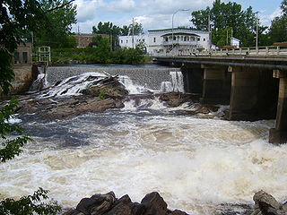
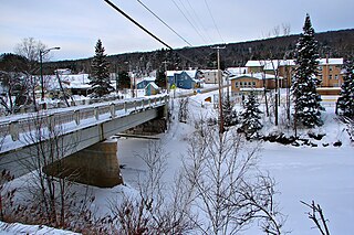
Mont-Laurier is a town and incorporated municipality in northwest Quebec, Canada, located on the banks of the Lièvre River, a tributary of the Ottawa River. Known as the "Capital of the Haute-Laurentides", the motto of the town is Laurus elationis praemium, which translates to "Lift the laurels of reward". The demonym for its inhabitants is Lauriermontois.

<span class="mw-page-title-main">L'Ange-Gardien, Outaouais, Quebec</span> Municipality in Quebec, Canada

L'Ange-Gardien is a municipality in the Outaouais region of Quebec, Canada. It constitutes the easternmost part of Les Collines-de-l'Outaouais Regional County Municipality, north of the Buckingham Sector of the City of Gatineau.

<span class="mw-page-title-main">Notre-Dame-de-la-Salette, Quebec</span> Municipality in Quebec, Canada

Notre-Dame-de-la-Salette is a municipality in the Outaouais region of Quebec, Canada. It is part of the Papineau Regional County Municipality, straddling the eastern banks of the Du Lièvre River.

<span class="mw-page-title-main">Val-des-Bois, Quebec</span> Municipality in Quebec, Canada

Val-des-Bois is a town and municipality in the Papineau Regional County Municipality in the Outaouais region of Quebec, Canada. The town is located on the eastern shores of the Du Lièvre River, 47 kilometers (29 mi) north of Buckingham.

<span class="mw-page-title-main">Notre-Dame-des-Sept-Douleurs, Quebec</span> Parish municipality in Quebec, Canada

Notre-Dame-des-Sept-Douleurs is an island municipality in the Bas-Saint-Laurent region of Quebec, Canada, part of the Rivière-du-Loup Regional County Municipality. It is located on and contiguous with Île Verte in the Estuary of St. Lawrence, about 20 kilometres (12 mi) north-east of Rivière-du-Loup. The name Île Verte was given in 1621 by Samuel de Champlain written "Isle Verte".

<span class="mw-page-title-main">Notre-Dame-de-la-Paix, Quebec</span> Municipality in Quebec, Canada

Notre-Dame-de-la-Paix is a town and municipality in the Outaouais region of Quebec, Canada, part of the Papineau Regional County Municipality.

<span class="mw-page-title-main">Sainte-Anne-du-Lac</span> Municipality in Quebec, Canada

Sainte-Anne-du-Lac is a municipality and village in the Laurentides region of Quebec, Canada, part of the Antoine-Labelle Regional County Municipality.

<span class="mw-page-title-main">Labelle, Quebec</span> Municipality in Quebec, Canada

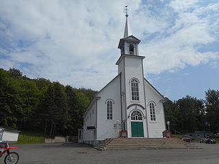
Labelle is a village and municipality in the Laurentides region of Quebec, Canada, part of the Les Laurentides Regional County Municipality. Its large "L"-shaped territory surrounds Lake Labelle, and the village is located along the Rouge River and Route 117.

<span class="mw-page-title-main">Notre-Dame-des-Pins, Quebec</span> Parish municipality in Quebec, Canada

Notre-Dame-des-Pins is a parish municipality in the Beauce-Sartigan Regional County Municipality in the Chaudière-Appalaches region of Quebec, Canada. Its population is 1,812 as of the Canada 2021 Census.

<span class="mw-page-title-main">Notre-Dame-de-Pontmain</span> Municipality in Quebec, Canada

Notre-Dame-de-Pontmain is a municipality in the Laurentides region of Quebec, Canada, part of the Antoine-Labelle Regional County Municipality.

<span class="mw-page-title-main">Lac-du-Cerf</span> Municipality in Quebec, Canada

Lac-du-Cerf is a municipality in the Laurentides region of Quebec, Canada, part of the Antoine-Labelle Regional County Municipality. It is located on and named after Lac du Cerf.

<span class="mw-page-title-main">Kiamika, Quebec</span> Municipality in Quebec, Canada

Kiamika is a municipality in the Laurentides region of Quebec, Canada, part of the Antoine-Labelle Regional County Municipality.

<span class="mw-page-title-main">Lac-Saguay</span> Village municipality in Quebec, Canada

Lac-Saguay is a village municipality in Antoine-Labelle Regional County Municipality in the Laurentides region of Quebec, Canada.

<span class="mw-page-title-main">Lac-Saint-Paul, Quebec</span> Municipality in Quebec, Canada

Lac-Saint-Paul is a municipality in the Laurentides region of Quebec, Canada, part of the Antoine-Labelle Regional County Municipality.

<span class="mw-page-title-main">Mont-Saint-Michel, Quebec</span> Municipality in Quebec, Canada

Mont-Saint-Michel is a municipality in the Laurentides region of Quebec, Canada, part of the Antoine-Labelle Regional County Municipality.

<span class="mw-page-title-main">Ferme-Neuve</span> Municipality in Quebec, Canada

Ferme-Neuve is a municipality part of the Antoine-Labelle Regional County Municipality, in the Laurentides region of Quebec, Canada. It is the largest incorporated municipality of the Laurentides region.

<span class="mw-page-title-main">L'Ascension, Quebec</span> Municipality in Quebec, Canada

L'Ascension is a municipality in the Laurentides region of Quebec, Canada, part of the Antoine-Labelle Regional County Municipality. The area is known as La Vallée de la Rouge.

<span class="mw-page-title-main">Notre-Dame-des-Neiges</span> Municipality in Quebec, Canada

Notre-Dame-des-Neiges is a municipality in Quebec, Canada. It encircles the city of Trois-Pistoles and includes the offshore Île aux Basques.

<span class="mw-page-title-main">Notre-Dame-de-Lourdes, Centre-du-Québec, Quebec</span> Parish municipality in Quebec, Canada

Notre-Dame-de-Lourdes is a parish municipality in Quebec.

<span class="mw-page-title-main">Notre-Dame-de-la-Merci</span> Municipality in Quebec, Canada

Notre-Dame-de-la-Merci is a municipality in the Lanaudière region of Quebec, Canada, part of the Matawinie Regional County Municipality.

References

  1. "Reference number 44882 in Banque de noms de lieux du Québec". toponymie.gouv.qc.ca (in French). Commission de toponymie du Québec.
  2. 1 2 "Geographic code 79005 in the official Répertoire des municipalités". www.mamh.gouv.qc.ca (in French). Ministère des Affaires municipales et de l'Habitation.
  3. 1 2 3 "Notre-Dame-du-Laus, Municipalité (MÉ) Census Profile, 2021 Census of Population". www12.statcan.gc.ca. Government of Canada - Statistics Canada. Retrieved 4 July 2022.
  4. 1 2 3 4 "Notre-Dame-du-Laus (Municipalité)" (in French). Commission de toponymie du Québec. Retrieved 2009-08-13.
  5. Luc Coursol. "Municipalité, Les premiers occupants". Notre-Dame-du-Laus. Retrieved 2009-08-14.
  6. "2021 Community Profiles". 2021 Canadian Census . Statistics Canada. February 4, 2022. Retrieved 2022-08-23.
  7. "2016 Community Profiles". 2016 Canadian Census . Statistics Canada. August 12, 2021. Retrieved 2022-07-04.
  8. "2011 Community Profiles". 2011 Canadian Census . Statistics Canada. March 21, 2019. Retrieved 2023-07-26.
  9. "2006 Community Profiles". 2006 Canadian Census . Statistics Canada. August 20, 2019.
  10. "2001 Community Profiles". 2001 Canadian Census . Statistics Canada. July 18, 2021.