
Nadathara is a residential area situated in the City of Thrissur in Kerala state of India. Nadathara is Ward 22 of Thrissur Municipal Corporation. As of 2001 India census, Nadathara had a population of 12,593. Males constitute 49% of the population and females 51%. Nadathara has an average literacy rate of 84%, higher than the national average of 59.5%: male literacy is 86%, and female literacy is 82%.
Ancheri is a residential area situated in the City of Thrissur in Kerala state of India. Ancheri is Ward 25 of Thrissur Municipal Corporation.
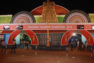
Thrissur Pooram Exhibition or commonly known as the All India Agricultural, Industrial, Educational and Cultural Exhibition is an exhibition organised jointly by Paramekkavu Bagavathi Temple Devaswom and Thiruvambadi Sri Krishna Temple Devaswom, ahead of Thrissur Pooram in Thekkinkadu Maidan in Thrissur city. It is usually conducted over a period of 40 to 50 days during the Thrissur Pooram.The exhibition is the largest in Kerala in terms of attendance and floor space.
The Thrissur Municipal Corporation is the civic body that governs the Thrissur city in Kerala, India. It is the third largest city Corporation in the state of Kerala by area and population. Established as a Municipality since 1921 under the Cochin Municipal Regulations, it is responsible for civic infrastructure and administration; the distribution of electricity and water for Thrissur city. The Corporation manages 101.42 km of Thrissur city limits of through 55 wards through five zones Ayyanthole, Vilvattom, Ollukkara, Ollur and Koorkanchery.

The city of Thrissur is situated in the southwest of the South Indian state of Kerala of Thrissur district. A landlocked city, Thrissur is located on a hillock which is surrounded by Thrissur Kole Wetlands. Thrissur district borders with Palakkad district in east, Malappuram district in the north, Ernakulam district in the South and Arabian Sea in the west.
Peringavu is a residential area situated in the City of Thrissur in Kerala state of India. Peringavu is Ward 5 of Thrissur Municipal Corporation.
Cheroor is a residential area situated in the City of Kasaragod in Kerala state of India.
Kalathodu is a residential area situated in the City of Thrissur in Kerala state of India. Kalathodu is Ward 20 of Thrissur Municipal Corporation.
Chelakkottukara is a residential area situated in the City of Thrissur in Kerala state of India. Chelakkottukara is Ward 21 of Thrissur Municipal Corporation. Important locations: Jubilee Mission Medical college, Thope Stadium, Mar Aprem Church, St. Thomas H.S.S Thope, Seventh Day Adventist Senior Secondary School, Mar Thimotheus High School.
Edakkunni is a residential area situated in the City of Thrissur in Kerala state of India. Edakkunni is Ward 28 of Thrissur Municipal Corporation.
Thaikkattussery is a residential area situated in the City of Thrissur in Kerala state of India. Thaikkattussery is Ward 29 of Thrissur Municipal Corporation.
Vadookkara is a residential area situated in the City of Thrissur in Kerala state of India. Vadookkara is Ward 39 of Thrissur Municipal Corporation.
Nedupuzha is a residential area situated in the City of Thrissur in Kerala state of India. Nedupuzha is Ward 42 of Thrissur Municipal Corporation.
Karyattukara is a residential area situated in the City of Thrissur in Kerala state of India. Karyattukara is Ward 45 of Thrissur Municipal Corporation.
Chettupuzha is a residential area situated in the City of Thrissur in Kerala state of India. Chettupuzha is Ward 44 of Thrissur Municipal Corporation.
Elthuruth is a residential area situated in the city of Thrissur in Kerala state of India. Elthuruth is Ward 45 of Thrissur Municipal Corporation. This is one of the most scenic suburbs of Thrissur corporation. The place is surrounded by paddy fields and canals forming a branch of kole wetlands. St. Aloysius School and College are the educational institutions serving this area.
Chavakkad Beach is beach in Chavakkad Municipality of Thrissur District in Kerala State. It lies on the coast of Arabian Sea and attracts domestic tourists and local people. The beach is situated 5 Kilometers from Guruvayoor Temple Sri Krishna Temple. In this beach, the river meets the sea known as estuary. The meeting point is known as Azhimokam in Malayalam. It is counted amongst Kerala’s most popular beaches because the beach is unexplored by domestic tourists.
Administration of Thrissur is handled by the Thrissur Municipal Corporation, consisting of 55 councilors and headed by the city's mayor.

Thrissur District has four types of administrative hierarchies:


