Augathella is a rural town and locality in the Shire of Murweh, Queensland, Australia. In the 2021 census, the locality of Augathella had a population of 328 people.

Morven is a rural town and locality in the Shire of Murweh, Queensland, Australia. In the 2021 census, the locality of Morven had a population of 184 people.

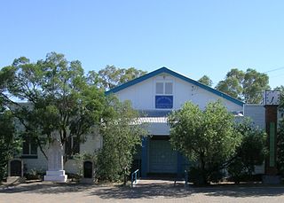
The Shire of Murweh is a local government area in the Maranoa district, which is part of South West Queensland, Australia. The administrative centre and largest town in the shire is Charleville.
Veteran is a rural residential locality in the Gympie Region, Queensland, Australia. In the 2021 census, Veteran had a population of 959 people.

Ballard is a rural locality in the Lockyer Valley Region, Queensland, Australia. In the 2021 census, Ballard had a population of 167 people.

Taranganba is a town and locality in the Livingstone Shire, Queensland, Australia. In the 2021 census, the locality of Taranganba had a population of 2,275 people.
Airdmillan is a coastal locality in the Shire of Burdekin, Queensland, Australia. In the 2021 census, Airdmillan had a population of 154 people.

Sommariva is a locality in the Shire of Murweh, Queensland, Australia. It is situated 37.9 kilometres (23.5 mi) east of Charleville and 57.4 kilometres (35.7 mi) west of Morven on the Warrego Highway. In the 2021 census, Sommariva had a population of 25 people.

Cooladdi is a rural town and locality in the Shire of Murweh, Queensland, Australia. The town is 88.9 kilometres (55.2 mi) south-west of Charleville.
Riversleigh is a rural locality in the Shire of Murweh, Queensland, Australia. In the 2021 census, Riversleigh had a population of 6 people.
Langlo is a locality in the Shire of Murweh, Queensland, Australia. In the 2021 census, Langlo had a population of 34 people.
Mount Gardiner is a rural locality in the Livingstone Shire, Queensland, Australia. In the 2021 census, Mount Gardiner had a population of 19 people.
Boatman is a locality in the Shire of Murweh, Queensland, Australia. In the 2021 census, Boatman had a population of 18 people.
Redford is a locality split between the Maranoa Region and the Shire of Murweh, both in Queensland, Australia. In the 2021 census, Redford had a population of 18 people.
Caroline Crossing is a rural locality in the Shire of Murweh, Queensland, Australia. In the 2021 census, Caroline Crossing had a population of 44 people.

Nive is a rural locality in the Shire of Murweh, Queensland, Australia. It is on the boundary between the Shire of Murweh and the Blackall-Tambo Region. In the 2021 census, Nive had a population of 44 people.
Ward is a rural locality in the Shire of Murweh, Queensland, Australia. In the 2021 census, Ward had a population of 87 people.
Tyrconnel is a rural locality split between the Maranoa Region and the Shire of Murweh, both in Queensland, Australia. In the 2021 census, Tyrconnel had a population of 17 people.

Coorooman is a rural coastal locality in the Livingstone Shire, Queensland, Australia. In the 2021 census, Coorooman had a population of 97 people.
Murweh is a rural locality in the Shire of Murweh, Queensland, Australia. In the 2021 census, Murweh had a population of 9 people.
