Cliff/Cannon, Spokane

Last updated
Cliff/Cannon
Cliff-Cannon, Spokane, WA, USA - panoramio.jpg
Cliff/Cannon in the foreground south of Interstate 90
Cliff-Cannoncropped.png
Location within the city of Spokane
Coordinates: 47°38′43.5″N117°25′32.3″W / 47.645417°N 117.425639°W / 47.645417; -117.425639
CountryUnited States
StateWashington
County Spokane
CitySpokane
Population
  Total8,352
  [1]
Time zone UTC-8 (PST)
  Summer (DST) UTC-7 (PDT)
ZIP Codes
99204, 99203
Area code 509

Cliff/Cannon is a neighborhood in Spokane, Washington. [2] It is located immediately south of Downtown, Spokane, and on the lower reaches of the broader South Hill. The neighborhood is home to a medical district with Sacred Heart and Deaconess both having their main hospital campuses along Cliff/Cannon's denser northern edge. To the south the neighborhood becomes more residential. City parks break up the residential zoning of the southern half of Cliff/Cannon. It is adjacent to the Cannon Hill area of the neighboring but separate Manito/Cannon Hill neighborhood. [3] The Marycliff-Cliff Park Historic District, a National Historic District listed on the National Register of Historic Places, is located within the neighborhood. [4]

Contents

Geography

The cliff for which the neighborhood is named CliffCannon Cliff Pano.png
The cliff for which the neighborhood is named

Cliff/Cannon is a neighborhood in Spokane located on the south side of the city. Cliff/Cannon is located directly between the central business district and the more suburban, residential South Hill.

There are multiple medical campuses in the northern portion of the neighborhood, from roughly Monroe Street on the west to Division Street to the east, and extending beyond out of the neighborhood into East Central. This large medical district with the campuses of both Sacred Heart and Deaconess hospitals borders the central business district of Spokane, which lies immediately to the north on the other side of Interstate 90. [3]

Lewis and Clark High School, which serves the neighborhood and broader South Hill area is located between the two hospital campuses, just south of I-90. [3]

The neighborhood is defined by the hillsides on which it is located. The northernmost portion of the neighborhood at Interstate 90 is in the relatively flat valley of the Spokane River. To the south at 16 Avenue, the neighborhood rises above the river to the level of the surrounding Columbia Plateau. On the west the boundary of the neighborhood is defined by the steep hillside dropping down to Latah Creek. Terrain generally increases in elevation as you move northwest to southeast through the neighborhood, with the steepest and most dramatic inclines found on the northern and western areas of Cliff/Cannon. [5]

History

Anthony McCue Cannon (1839-1895) Anthony McCue Cannon (1839-1895).png
Anthony McCue Cannon (1839–1895)

The Spokane inhabited what is now Cliff/Cannon for hundreds of years before European settlers arrived. The Spokane used the basalt outcroppings in the area as vistas, looking out across the broad valley and plains that surround the area. [6]

The first European settler in what is now Cliff/Cannon was Reverend Henry Thomas Cowley. Cowley, with the help of some of the native Spokane, built a log cabin and school in what is now Cowley Park in the northeastern corner of the neighborhood. The school became a gathering place for the native population. [3]

Development of the neighborhood began to accelerate in 1883, when the western area known as Cannon's Addition was platted by Anthony McCue Cannon. Initial development of Cannon's Addition was focused on wealthy and powerful residents of the nascent city of Spokane. Large mansions were built along the base and crest of the basalt cliff which runs roughly parallel to the Spokane River in downtown. [3] One of the founders of Spokane, James N. Glover built a Tudor Revival mansion below the cliff at 8th and Washington in 1888. [7] Railroad magnate D.C. Glover built a Colonial Revival mansion nearby at 7th and Stevens in 1898. [8] Like many homes in the neighborhood, both were designed by architect Kirtland Cutter, who was a prolific architect in the early decades of Spokane. Both are also listed on the National Register of Historic Places, [7] [8] as is the wider Marycliff-Cliff Park Historic District. [9]

Undercliff House.png
Corbin House Marycliff.png
The Undercliff and Corbin House at the Marycliff Center

The school that would eventually become Lewis and Clark was first built at Fourth and Stevens in 1883, and then moved a block away in 1891. The school, originally known as Central High school, then known as South Central High School, to contrast with North Central High School north of the river, burned down in 1910. The school was rebuilt in 1911 in the Collegiate Gothic style and took on its present name of Lewis and Clark. [3] The new school's cornerstone was laid by former President Teddy Roosevelt on April 8, 1911. [10]

In 1904 the Cliff Park section of the neighborhood began to develop around the eponymous 4.5-acre (0.018 km2) park which surrounds a volcanic basalt outcropping that rises above the surrounding area. The first decade of the 1900s also saw development continue in Cannon's Addition to the west. An area along 9th Avenue in Cannon's Addition featuring large Tudor Revival, Queen Anne and neoclassical homes alongside more modest bungalow and Craftsman homes. The Ninth Avenue Historic District is listed on the National Register of Historic Places. [11] Between 1900 and 1910, 264 homes were built in the Cliff Park and Cannon's Addition areas that have remained intact (as of 2021). This explosion in growth was facilitated by the arrival of a streetcar line that made traversing the steep incline of the lower South Hill easier, and thus the neighborhood is an example of a streetcar suburb. [12] Prior to the streetcar, the first being the ill-fated line on the Monroe Street hill built in 1890 which snapped in the winter of 1894 and then the electric line that ran up Cannon Hill along Maple, Madison, Jefferson, and Adams, the neighborhood was overlooked for development in favor of flatter areas in downtown and Browne's Addition. [12] [13] Unlike previous waves of construction, the first decade of the 20th century saw the arrival of less wealthy and minority groups. [13] The neighborhood was one of few areas where African-American and Jewish residents could purchase a home. [12]

In 1931, students from Lewis and Clark High School, which is located in the northern and lower portion of the neighborhood, built a path known as the Tiger Trail, for the school's mascot, up the hill through what is now Edwidge Woldson Park. As of 2018, the path is still used to connect the lower portion of the neighborhood, and the city, with the upper areas. [14] The park was established as Pioneer Park in 1945 when the city purchased the Corbin House and adjacent properties and gardens. [3]

The Park Inn was established at Ninth and Grand in 1932. It has been in continuous operation at that location ever since, making it Spokane's oldest restaurant. [15]

From 1965 to 1971, Interstate 90 was built across the entire northern edge of the neighborhood, resulting in the demolition of many historic structures. [3]

Historic places

In addition to Marycliff-Cliff Park and Ninth Avenue Historic Districts, Cliff/Cannon is home to 17 other properties listed on the National Register of Historic Places on their own merit.

[16] Name on the RegisterImageDate listed [17] LocationDescription
1 Dr. Robert and Jessie Bell House
Dr. Robert and Jessie Bell House Dr. Robert and Jessie Bell House.JPG
Dr. Robert and Jessie Bell House
August 24, 2005
(#05000921)
917 S. Lincoln St.
47°38′57″N117°25′27″W / 47.649167°N 117.424167°W / 47.649167; -117.424167 (Dr. Robert and Jessie Bell House)
Built in 1908.
2 J. W. Binkley House
J. W. Binkley House J.W. Binkley House.JPG
J. W. Binkley House
March 31, 1989
(#89000211)
628 S. Maple
47°39′01″N117°26′06″W / 47.650278°N 117.435°W / 47.650278; -117.435 (J. W. Binkley House)
3 Breslin
Breslin The Breslin.JPG
Breslin
February 12, 1987
(#87000095)
S. 729 Bernard
47°38′56″N117°24′54″W / 47.648889°N 117.415°W / 47.648889; -117.415 (Breslin)
Built in 1910.
3 Kenneth and Edna Brooks House
Kenneth and Edna Brooks House Kenneth and Edna Brooks House.JPG
Kenneth and Edna Brooks House
September 15, 2004
(#04001006)
723 W. Sumner Ave.
47°38′48″N117°25′15″W / 47.646667°N 117.420833°W / 47.646667; -117.420833 (Kenneth and Edna Brooks House)
Built in 1956.
4 Coolidge-Rising House
Coolidge-Rising House Coolidge-Rising House.JPG
Coolidge-Rising House
May 19, 1988
(#88000598)
W. 1405 Ninth Ave.
47°38′50″N117°25′54″W / 47.6472°N 117.4317°W / 47.6472; -117.4317 (Coolidge-Rising House)
Built circa 1906.
5 Corbet-Aspray House
Corbet-Aspray House Corbet-Aspray House.JPG
Corbet-Aspray House
November 30, 1999
(#99001454)
820 W. 7th Ave.
47°38′59″N117°25′22″W / 47.6497°N 117.4228°W / 47.6497; -117.4228 (Corbet-Aspray House)
Built in 1908.
6 Daniel C. and Anna Corbin House
Daniel C. and Anna Corbin House Corbin House.JPG
Daniel C. and Anna Corbin House
May 10, 2004
(#04000157)
507 W. Seventh Ave.
47°39′02″N117°25′11″W / 47.6506°N 117.4197°W / 47.6506; -117.4197 (Daniel C. and Anna Corbin House)
Built in 1898.
7 Cowley Park
Cowley Park Cowley Park NRHP 73001891 Spokane County, WA.jpg
Cowley Park
February 6, 1973
(#73001891)
S. Division St. between 6th and 7th Aves.
47°38′58″N117°24′39″W / 47.6494°N 117.4108°W / 47.6494; -117.4108 (Cowley Park)
Built in 1917
8 First Congregational Church of Spokane
First Congregational Church of Spokane First Congregational Spokane.JPG
First Congregational Church of Spokane
April 26, 1978
(#78002775)
W. 311-329 4th Ave.
47°39′08″N117°24′59″W / 47.652222°N 117.416389°W / 47.652222; -117.416389 (First Congregational Church of Spokane)
Built in 1890.
9 Glover House
Glover House Glover House.JPG
Glover House
August 14, 1973
(#73001892)
W. 321 8th Ave.
47°38′54″N117°24′57″W / 47.648333°N 117.415833°W / 47.648333; -117.415833 (Glover House)
Built circa 1888, this home was designed by Kirtland Cutter.
10 Hill–Hilscher House
Hill-Hilscher House Hill-Hilscher House 1638 S Cedar, Spokane, WA.jpg
Hill–Hilscher House
January 8, 2014
(#13001063)
1638 S. Cedar St.
47°38′22″N117°25′58″W / 47.639576°N 117.432784°W / 47.639576; -117.432784 (Hill–Hilscher House)
11 Knickerbocker
Knickerbocker Knickerbocker.JPG
Knickerbocker
February 12, 1987
(#87000096)
S. 501-507 Howard
47°39′05″N117°25′10″W / 47.651389°N 117.419444°W / 47.651389; -117.419444 (Knickerbocker)
Built in 1912.
12 Levesque-Majer House
Levesque-Majer House Levesque-Majer House NRHP 14001162 Spokane County, WA.jpg
Levesque-Majer House
January 14, 2015
(#14001162)
1708 S. Maple Blvd.
47°38′20″N117°26′03″W / 47.6389°N 117.4342°W / 47.6389; -117.4342 (Levesque-Majer House)
13 Lewis and Clark High School
Lewis and Clark High School LcPostcard.jpg
Lewis and Clark High School
December 6, 1990
(#90001860)
W. 521 4th Ave.
47°39′08″N117°25′09″W / 47.652222°N 117.419167°W / 47.652222; -117.419167 (Lewis and Clark High School)
14 Victor & Jean Piollet House
Victor & Jean Piollet House Piollet House NRHP 10001019 Spokane County, WA.jpg
Victor & Jean Piollet House
December 13, 2010
(#10001019)
606 W. 16th Ave.
47°38′28″N117°25′15″W / 47.641111°N 117.420833°W / 47.641111; -117.420833 (Victor & Jean Piollet House)
15 Robinwood Apartments
Robinwood Apartments Robinwood Apartments NRHP 05000248 Spokane County, WA.jpg
Robinwood Apartments
March 30, 2005
(#05000248)
209-223 West Ninth Ave.
47°38′57″N117°24′54″W / 47.649167°N 117.415°W / 47.649167; -117.415 (Robinwood Apartments)
Built in 1939.
16 Roosevelt Apartments
Roosevelt Apartments Roosevelt Apartments.JPG
Roosevelt Apartments
August 10, 2000
(#00000969)
524 W. Seventh Ave.
47°38′59″N117°24′59″W / 47.649722°N 117.416389°W / 47.649722; -117.416389 (Roosevelt Apartments)
Built in 1929.
17 Lawrence and Lydia Weaver House
Lawrence and Lydia Weaver House Weaver House.JPG
Lawrence and Lydia Weaver House
March 13, 2002
(#02000186)
520 W. 16th Ave.
47°38′29″N117°25′07″W / 47.641389°N 117.418611°W / 47.641389; -117.418611 (Lawrence and Lydia Weaver House)
Built in 1910.

Demographics

Plymouth Congregational Church PlymouthCongregationalChurchSpokane.jpg
Plymouth Congregational Church

As of 2017, the population of Cliff/Cannon was 8,352 in 4,619 households. 68.8% of those households are rented, compared with 45.3% for the city. 16.8% of Cliff/Cannon residents are 19 years or under, compared to 21.9% citywide. 12.3% are age 65 or above, compared to 14.5% citywide. 22.7% of people in Cliff/Cannon identify as people of color, compared to 15.1% citywide. The median household income in Cliff/Cannon is $33,045, compared to $44,768 for the whole city. [1]

90.8% of residents were born in the United States. Of foreign born residents, 16.4% came from the Philippines, 14% from Burma, 9.3% from Canada and 5.5% from Mexico. [1]

Education

View from the Tiger Trail, named for and often used by students of LCHS Tiger Trail (19039963818).jpg
View from the Tiger Trail, named for and often used by students of LCHS

Cliff/Cannon is served by Spokane Public Schools and home to two schools, both public. Roosevelt Elementary is located on 14th Avenue and serves the entire neighborhood with the exception of one square block in the far southwest that is served by Wilson Elementary in the adjacent Manito/Cannon Hill neighborhood. Both schools feed into Sacajawea Middle School in the Comstock neighborhood before feeding into Lewis and Clark High School, which is located on 4th Avenue in Cliff/Cannon. [18] [19]

Transportation

Highway

I-90 passes east–west as the northern boundary of Cliff/Cannon. [20]

U.S. 2 passes east–west as the northern boundary of Cliff/Cannon concurrent with I-90 to Division Street. [20]

U.S. 395 passes east–west as the northern boundary of Cliff/Cannon concurrent with I-90 to Division Street. [20]

Surface Streets

An entrance to the neighborhood just south of downtown and I-90 on Jefferson Street JeffersonStreetSpokane.jpg
An entrance to the neighborhood just south of downtown and I-90 on Jefferson Street

Interstate 90 defines the northern border of the neighborhood, and has exits at Maple Street, Lincoln Street and Division Street. On ramps are located at Maple Street, Monroe Street and Division Street. U.S. Route 2 runs along a concurrency with I-90 through Cliff/Cannon. [21] The area is somewhat notable for its small concentration of red brick streets. Some of the oldest streets in the city are in the Cliff/Cannon neighborhood on Spokane's lower South Hill, where there are multiple blocks of extant brick roads that were laid in the early 20th century. [22] The exposed brick sections of Madison Street, between Fifth and Sixth Avenue and Eighth and Ninth Avenue were laid down on August 6, 1908. [22] Most of the areas that once had brick streets have been covered by a layer of cheaper-to-maintain asphalt by city maintenance crews over the years and can only be seen when potholes form and expose them.

A pedestrian stairway, known as the Tiger Trail after Lewis and Clark High School's mascot, traverses the cliff through Edwidge Woldson Park from Cliff Drive to Seventh Avenue, three blocks due south of the high school. The trail was constructed in 1931 and is still used to this day by Lewis and Clark students traveling to and from school, as well as the general public. [14]

Public Transit

Cliff/Cannon, like the rest of the Spokane metropolitan area, has public transit provided by the Spokane Transit Authority. The STA serves Cliff/Cannon with four fixed-route bus lines. [23]

RouteTerminiService operation and notesStreets traveled
4
Moran Prairie
Downtown Spokane
STA Plaza
Glenrose
Moran Station Park & Ride
Frequent routeSprague, Washington/Stevens, 8th/9th, Grand
12
Southside Medical Shuttle
Downtown Spokane
STA Plaza
University District
Gateway Bridge
Shuttle routeWall, 6th, Bernard, 5th, Division, 7th, McClellan, 8th, Rockwood, Cowley
14
South Adams
Downtown Spokane
STA Plaza
Cliff/Cannon
Regular routeWall, 5th, Adams, 10th, Madison, 14th, Cedar, 8th
43
Lincoln/37th
Downtown Spokane
STA Plaza
Lincoln Heights
South Hill Park & Ride
Regular routeMaple/Walnut, 14th, Lincoln

Related Research Articles

<span class="mw-page-title-main">Hillyard, Spokane</span> Neighborhood of Spokane in Spokane County, Washington, United States

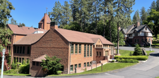
Hillyard is a neighborhood in Spokane, Washington which existed as a separate town between 1892 and 1924.

<span class="mw-page-title-main">West Central, Spokane</span> Neighborhood in Spokane, Washington, U.S.

West Central is a neighborhood in Spokane, Washington. As the name suggests it is located centrally on the west side of the city. Downtown Spokane is immediately east of the neighborhood, and spreads into West Central along Monroe Street in the Kendall Yards area. The neighborhood is diverse, with single and multi-family residential zones dating back to the early days of Spokane, a new mixed use development on the site of a former rail yard, the Spokane County Courthouse campus and associated government buildings and a few commercial districts. The Spokane River gorge winds around the southern and western edge of the neighborhood. It is home to Nettleton's Addition Historic District, which was added to the National Register of Historic Places in March 2006, and is also the largest historic district on the Washington State Heritage Register.

<span class="mw-page-title-main">Logan, Spokane</span> Spokane Neighborhood in Washington, United States

Logan is a neighborhood in Spokane, Washington. It is located immediately northeast of Downtown Spokane and is home to Gonzaga University. The Spokane River runs along its eastern and southern edge. Due to its proximity to the city center, Logan is home to some of the oldest and densest areas in the city. It is known for its tree-lined streets, historic buildings and population of college students. In addition to numerous individual properties, there are two historic districts listed on the National Register of Historic Places located within Logan: the Desmet Avenue Warehouse Historic District and the Mission Avenue Historic District.

<span class="mw-page-title-main">East Central, Spokane</span> Spokane Neighborhood in Washington, United States

East Central is a neighborhood in Spokane, Washington. As the name suggests, it is on the east side of Spokane and centrally located. The official neighborhood is expansive and covers multiple areas considered by locals to be independent neighborhoods, such as the Sprague Union District on East Sprague Avenue, the South Perry District, the Underhill Park area and the University District on the eastern fringe of Downtown Spokane.

<span class="mw-page-title-main">Browne's Addition, Spokane</span> Spokane Neighborhood in Washington, United States

Browne's Addition, often referred to shorthand as just Browne's, is a neighborhood in Spokane, Washington. It is located directly west of Downtown Spokane and is one of the oldest and densest neighborhoods in the city. The area is known for its numerous historic mansions, many of which have been converted into multi-family apartments. The terrain is flat in the neighborhood despite the degree of topographical relief in the immediate surrounding area. Latah Creek cuts a deep valley to the west, separating Browne's Addition from the Sunset Hill portion of the West Hills neighborhood and the Spokane River gorge drops off dramatically to the north into the Peaceful Valley neighborhood. The South Hill area of Spokane rises to the southwest.

<span class="mw-page-title-main">Peaceful Valley, Spokane</span> Spokane Neighborhood in Washington, United States

Peaceful Valley is a neighborhood in Spokane, Washington. It sits directly below Downtown Spokane on the Spokane River under its falls. The neighborhood snakes along the thin floodplain on the valley floor of the Spokane River Gorge. It is the smallest neighborhood in the city by both area and population, but due to its central location and unique character it is quite notable. The neighborhood has a working class and bohemian culture.

<span class="mw-page-title-main">Rockwood, Spokane</span> Spokane Neighborhood in Washington, United States

Rockwood is a neighborhood in Spokane, Washington. It is located on the south side of the city to the southeast of Downtown Spokane and expanding southeasterly from close to the city center. Its proximity to downtown makes it one of Spokane's older neighborhoods, with mature trees lining most of its streets. Due to its location on the hill leading up from the Spokane River Valley, the street grid breaks down in many places around Rockwood. The most notable of these is along the winding Rockwood Boulevard, which was designed by the Olmsted Brothers and weaves its way from the northwesternmost corner of the neighborhood through the center and across to the eastern border, highlighting the basalt bluffs and other natural topography.

<span class="mw-page-title-main">Manito/Cannon Hill, Spokane</span> Neighborhood in Spokane, Washington, United States

Manito/Cannon Hill is a neighborhood on the South Hill of Spokane, Washington. It is named after the two public parks that dominate its setting: Manito Park and Cannon Hill Park. Manito/Cannon Hill is a predominantly residential neighborhood made up mostly by single-family homes and city park land.

<span class="mw-page-title-main">Latah/Hangman, Spokane</span> Spokane Neighborhood in Washington, United States

Latah/Hangman is a neighborhood in Spokane, Washington.

<span class="mw-page-title-main">Emerson/Garfield, Spokane</span> Spokane Neighborhood in Washington, United States

Emerson/Garfield is a neighborhood in Spokane, Washington. It is located immediately north of Downtown Spokane's North Bank and extends out into the inner northwestern portion of the city. Emerson/Garfield is a diverse neighborhood with residential, commercial and civic zones all bordering one another, with density ranging from single-family homes to multi-use buildings. Due to its location in the central area of Spokane, Emerson/Garfield is criss-crossed by numerous arterials and thoroughfares. Along those main roads are numerous commercial and retail districts of importance to both the neighborhood and city as a whole.

<span class="mw-page-title-main">Lincoln Heights, Spokane</span> Spokane Neighborhood in Washington, United States

Lincoln Heights is a neighborhood in Spokane, Washington. It is located in the southeastern portion of the city in a broader area commonly known as the South Hill. As the name suggests, Lincoln Heights lies on the slopes and atop the crest of the South Hill area. Lincoln Heights is home to a mix of single-family residential, multi-family residential, and commercial areas and a significant amount of park land. The Lincoln Heights Shopping Center and surrounding area is one of the largest and most important commercial and retail districts on the entire south side of Spokane.

<span class="mw-page-title-main">Comstock, Spokane</span> Neighborhood in Washington, United States

Comstock is a neighborhood in Spokane, Washington. It is located on the south side of the city in a broader area commonly known as the South Hill. The neighborhood is primarily single-family residential, and a mix of homes built during the streetcar era and then built during the post-World War II housing boom. The neighborhood is also home to a few commercial districts, including the regionally important Manito Shopping Center, two schools, the eponymous Comstock Park, sports fields and a golf course.

<span class="mw-page-title-main">Grandview/Thorpe, Spokane</span> Spokane Neighborhood in Washington, United States

Grandview/Thorpe is a neighborhood in Spokane, Washington. Located in southwestern Spokane, the neighborhood takes its name from two roads that pass through. Grandview Boulevard, so named because of its location at the top of a ridge from which large swaths of Spokane, the Spokane Valley and surrounding mountains to the north and east such as Mount Spokane, can be seen, is located in the northern part of the neighborhood. Thorpe Road traverses a gully in the central and southern portion of the neighborhood.

<span class="mw-page-title-main">North Hill, Spokane</span> Spokane Neighborhood in Washington, United States

North Hill is a neighborhood in Spokane, Washington. As the name suggests, it is atop a hill on the north side of Spokane, within which it is centrally located and crossed by numerous major thoroughfares. It is home to parks, commercial districts and single family residential areas. The historic Garland Theater is located in North Hill, and the city's main north–south arterial, Division Street, is home to a major commercial district along the eastern edge of the neighborhood.

<span class="mw-page-title-main">Audubon/Downriver, Spokane</span> Spokane Neighborhood in Washington, United States

Audubon/Downriver is a neighborhood in Spokane, Washington, located on the northwest side of the city. There is a diversity of land use in the neighborhood, with single-family residential areas dating from the early 20th century through the Post–World War II economic expansion era, regionally important commercial districts, smaller neighborhood retail areas, numerous schools, large parks, a golf course, conservation areas and part of Riverside State Park along the Spokane River. The neighborhood is the site of the corporate offices for Rosauers Supermarkets, a regional grocery store chain with stores located across the Northwestern United States.

<span class="mw-page-title-main">Nevada Heights, Spokane</span> Spokane Neighborhood in Washington, United States

Nevada Heights is a neighborhood in Spokane, Washington, located on the north side of the city. Its southern border is atop a bluff that runs east–west across the north side of the city, which gives the neighborhood its name. Nevada Street, a major north–south arterial, runs through the neighborhood. The neighborhood is largely residential, but also home to large retail districts, medical facilities, schools and parks. Being surrounded by the city of Spokane on all sides, the neighborhood is well integrated into urban area.

<span class="mw-page-title-main">Shiloh Hills, Spokane</span> Spokane Neighborhood in Washington, United States

Shiloh Hills is a neighborhood in Spokane, Washington, located on the far northeastern side of the city. It is one of the newer areas of the city, initially annexed in the late 1960s with growth continuing into the 21st century. The neighborhood is home to residential, commercial and industrial districts as well as multiple regionally important transportation corridors such as the Division Street "Y".

<span class="mw-page-title-main">Glover Mansion</span> United States historic place

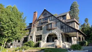
The Glover Mansion is a historic Tudor revival home built in 1888 and located in the Cliff/Cannon neighborhood of Spokane, Washington, just uphill from and overlooking the city's downtown. The home was designed by architect Kirtland Cutter for James N. Glover, who founded the city of Spokane in 1873. Over the years the Glover Mansion has served as a residence, housed Spokane's Unitarian Universalist Church, and more recently been used as an event venue.

<span class="mw-page-title-main">Marycliff-Cliff Park Historic District</span> United States historic place

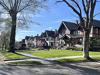
The Marycliff-Cliff Park Historic District is a historic residential area in the Cliff/Cannon neighborhood of Spokane, Washington, located immediately uphill from the city's downtown core, listed on the National Register of Historic Places (NRHP). The district is made up of two distinct but connected areas, the Marycliff section located at the base of a basalt cliff and south of Seventh Avenue, and the Cliff Park section located atop the cliff and north of 14th Avenue. Encroachment from the nearby city center has changed the nature of the Marycliff section over the decades. Of the palatial homes built in the late 1800s in the area, all have either been converted to commercial or public use or razed to make way for new development, though there are still a number of properties that are intact and reflect the historic nature of the area. The Cliff Park section retains its original residential character and historic nature, with only 11 properties listed as intrusive among the 118 properties in the area.

<span class="mw-page-title-main">Ninth Avenue Historic District</span> Historic district in Spokane, Washington

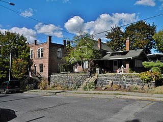
The Ninth Avenue Historic District is a National Register of Historic Places (NRHP) listed historic district located along and around Ninth Avenue in the Cliff/Cannon neighborhood of Spokane, Washington. It stretches from Monroe Street on the east to Chestnut Street on the west, running the length of Ninth Avenue and extending to include portions of Eighth, 10th and 11th Avenues, mostly in the western half of the district.

References

  1. 1 2 3 "Cliff/Cannon Neighborhood Snapshot" (PDF). spokanecity.org. City of Spokane. Retrieved 17 May 2022.
  2. "Cliff Cannon Neighborhood Council". spokanecity.org. City of Spokane. Retrieved 17 May 2022.
  3. 1 2 3 4 5 6 7 8 "Cliff Cannon Neighborhood Profile" (PDF). spokanecity.org. City of Spokane. Retrieved 17 May 2022.
  4. "NATIONAL REGISTER OF mSTORIC PLACES INVENTORY -- NOMINATION FORM" (PDF). historicspokane.org. National Park Service. Retrieved 7 August 2022.
  5. USGS (2020). "Spokane NW Quadrangle" (Quadrangle Map). usgs.gov. U.S. Geological Survey. Retrieved 17 May 2022.
  6. Rebstock, Tracy L. "Cliff Park". spokanehistorical.org. Eastern Washington University. Retrieved 17 May 2022.
  7. 1 2 "Glover Mansion". historicspokane.org. City - County of Spokane Historic Preservation Office. Retrieved 23 June 2022.
  8. 1 2 "Corbin House". historicspokane.org. City - County of Spokane Historic Preservation Office. Retrieved 23 June 2022.
  9. "Marycliff-Cliff Park Historic District". historicspokane.org. City - County of Spokane Historic Preservation Office. Retrieved 23 June 2022.
  10. "LC History". spokaneschools.org. Spokane Public Schools. Retrieved 23 June 2022.
  11. "National Register of Historic Places Registration Form" (PDF). historicspokane.org. U.S. Department of the Interior. Retrieved 23 June 2022.
  12. 1 2 3 Holm, Samantha (October 13, 2022). "The Cliff/Cannon neighborhood on Spokane's lower South Hill could get historic protections — if homeowners want it". Inlander. Retrieved October 21, 2022.
  13. 1 2 Deshais, Nicholas (11 January 2021). "Getting There: Preservationists seek to protect the South Hill 's architectural legacy, celebrate its streetcar connection". The Spokesman-Review.
  14. 1 2 Deshais, Nicholas (July 22, 2018). "The stories behind the stairs: Big steps taken to connect Spokane communities". The Spokesman-Review. Retrieved 17 May 2022.
  15. Brand, Nathan (9 January 2013). "Park Inn: The Untold Story". The Inlander. Retrieved 10 August 2022.
  16. Numbers represent an alphabetical ordering by significant words. Various colorings, defined here, differentiate National Historic Landmarks and historic districts from other NRHP buildings, structures, sites or objects.
  17. The eight-digit number below each date is the number assigned to each location in the National Register Information System database, which can be viewed by clicking the number.
  18. "Elementary School Boundary Map" (PDF). spokaneschools.org. Spokane Public Schools. Retrieved 14 June 2022.
  19. "High School Boundary Map" (PDF). spokaneschools.org. Spokane Public Schools. Retrieved 14 June 2022.
  20. 1 2 3 "Spokane NW Quadrangle". usgs.gov. U.S. Geological Survey. 2020. Archived from the original (7.5 minute quadrangle topographical map) on 3 May 2022. Retrieved 21 May 2022.
  21. "Official Arterial Street Map" (PDF). spokanecity.org. City of Spokane. Retrieved 17 May 2022.
  22. 1 2 Deshais, Nicholas (August 3, 2017). "Beneath the asphalt: Spokane's historic brick streets endure the decades". The Spokesman-Review. Retrieved July 17, 2022.
  23. "STA Transit Map July 2023" (PDF). spokanetransit.com. Spokane Transit Authority. Retrieved 16 July 2023.