Kirtland Cutter was a 20th-century architect in the Pacific Northwest and California. He was born in East Rockport, Ohio, the great-grandson of Jared Potter Kirtland. He studied painting and illustration at the Art Students League of New York. At the age of 26 he moved to Spokane, Washington, and began working as a banker for his uncle. By the 1920s, Cutter had designed several hundred buildings that established Spokane as a place rivaling Seattle and Portland, Oregon in its architectural quality. Most of Cutter's work is listed in State and National Registers of Historic Places.
The Ville is a historic African-American neighborhood with many African-American businesses located in North St. Louis, Missouri, U.S.. This neighborhood is a forty-two-square-block bounded by St. Louis Avenue on the north, Martin Luther King Drive on the south, Sarah on the east and Taylor on the west. From 1911 to 1950, The Ville was the center of African American culture within the city of St. Louis.
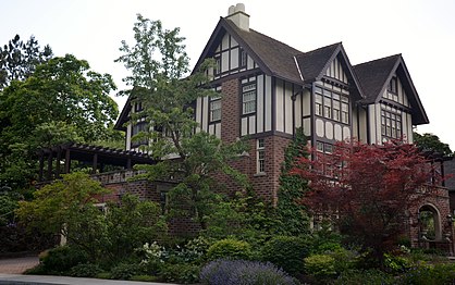
The Patsy Clark Mansion is a Spokane, Washington, United States, residence that was designed by architect Kirtland Cutter in 1897 for mining millionaire Patsy Clark. It is located at 2208 West Second Avenue in the city's historic Browne's Addition. The mansion had long been used as a restaurant. In 2002, a law firm purchased the mansion for $1.03 million in order to rescue the landmark from further deterioration. The mansion now houses a law firm, while still remaining open for private rentals for small events.

Neighborhoods in Spokane, Washington are officially grouped by the Spokane City Council into three main city council districts: 1, 2, and 3. Each city council district contains multiple, official neighborhoods that are recognized with a neighborhood council. Informally, neighborhoods are colloquially grouped by local geographical, geological, cultural, or historical features The list of neighborhoods below is organized based on the official designations by the City of Spokane. Unofficial neighborhoods and districts are listed within the official neighborhood in which they are located.

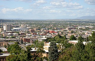
Downtown Spokane or Riverside is the central business district of Spokane, Washington. The Riverside neighborhood is roughly bounded by I-90 to the south, Division Street to the east, Monroe Street to the west and Boone Avenue to the north. The topography of Downtown Spokane is mostly flat except for areas downstream of the Spokane Falls which are located in a canyon; the elevation is approximately 1,900 feet (580 m) above sea level.

The Hillside Historic District in Waterbury, Connecticut is a 106-acre (43 ha) historic district that was listed on the National Register of Historic Places (NRHP) in 1987. It encompasses a residential area north of the city's central business district, and is bounded on the south by West Main Street, the west by Willow Avenue and Cliff and Frederick Streets, on the north by Buckingham Street and Woodland Terrace, and on the east by Cooke Street. Developed principally over an 80-year period between 1840 and 1920, it includes a cross-section of architectural styles of the 19th and early 20th centuries. The area was a desirable neighborhood of the city for much of this time, and was home to a number of the city's elite. In 1987, it included 395 buildings deemed to contribute to the historic character of the area, and one other contributing structure. It includes the Wilby High School and the Benedict-Miller House, which are both separately listed. 32 Hillside Road, a several acre property that includes the Benedict Miller House, was the original site of The University of Connecticut's Waterbury Branch until 2003.

Cutter & Malmgren was an architectural firm of Kirtland K. Cutter and Karl G. Malmgren in Spokane, Washington that existed from c.1889 to 1917. The firm designed multiple buildings that are listed on the U.S. National Register of Historic Places.

The Riverside Avenue Historic District is a 16.5 acres (6.7 ha) historic district in Downtown Spokane, Washington consisting of buildings constructed in the early 20th century, and was listed on the National Register of Historic Places in 1976. The listing includes 14 contributing properties, nine of which are considered primary and five are considered secondary.

Browne's Addition, often referred to shorthand as just Browne's, is a neighborhood in Spokane, Washington. It is located directly west of Downtown Spokane and is one of the oldest and densest neighborhoods in the city. The area is known for its numerous historic mansions, many of which have been converted into multi-family apartments. The terrain is flat in the neighborhood despite the degree of topographical relief in the immediate surrounding area. Latah Creek cuts a deep valley to the west, separating Browne's Addition from the Sunset Hill portion of the West Hills neighborhood and the Spokane River gorge drops off dramatically to the north into the Peaceful Valley neighborhood. The South Hill area of Spokane rises to the southwest.

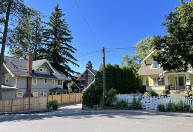
Rockwood is a neighborhood in Spokane, Washington. It is located on the south side of the city to the southeast of Downtown Spokane and expanding southeasterly from close to the city center. Its proximity to downtown makes it one of Spokane's older neighborhoods, with mature trees lining most of its streets. Due to its location on the hill leading up from the Spokane River Valley, the street grid breaks down in many places around Rockwood. The most notable of these is along the winding Rockwood Boulevard, which was designed by the Olmsted Brothers and weaves its way from the northwesternmost corner of the neighborhood through the center and across to the eastern border, highlighting the basalt bluffs and other natural topography.

Spokane and its neighborhoods contain a patchwork of architectural styles that give them a distinct identity and illustrate the changes throughout the city's history. Spokane has a rich architectural history for a western city of its size and much of it is a product of its circumstances at the turn of the 20th century when as a rapidly growing city, the Great Fire of 1889 destroyed 32 blocks of the city center which was quickly rebuilt in a more grand fashion by a community flush with money coming from regional mining districts. Many of the architects that found work in the city and building on the blank slate of the downtown commercial district became highly esteemed architects such as Kirtland Cutter, who has been credited with giving the city a distinctive character. In particular, the city has a high concentration of Romanesque Revival style institutional and commercial buildings and American Craftsman bungalow residences. The architecture of Spokane gained national recognition in industry publications in the early 20th century.
Cliff/Cannon is a neighborhood in Spokane, Washington. It is located immediately south of Downtown, Spokane, and on the lower reaches of the broader South Hill. The neighborhood is home to a medical district with Sacred Heart and Deaconess both having their main hospital campuses along Cliff/Cannon's denser northern edge. To the south the neighborhood becomes more residential. City parks break up the residential zoning of the southern half of Cliff/Cannon. It is adjacent to the Cannon Hill area of the neighboring but separate Manito/Cannon Hill neighborhood. The Marycliff-Cliff Park Historic District, a National Historic District listed on the National Register of Historic Places, is located within the neighborhood.

Emerson/Garfield is a neighborhood in Spokane, Washington. It is located immediately north of Downtown Spokane's North Bank and extends out into the inner northwestern portion of the city. Emerson/Garfield is a diverse neighborhood with residential, commercial and civic zones all bordering one another, with density ranging from single-family homes to multi-use buildings. Due to its location in the central area of Spokane, Emerson/Garfield is criss-crossed by numerous arterials and thoroughfares. Along those main roads are numerous commercial and retail districts of importance to both the neighborhood and city as a whole.
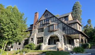
The Glover Mansion is a historic Tudor revival home built in 1888 and located in the Cliff/Cannon neighborhood of Spokane, Washington, just uphill from and overlooking the city's downtown. The home was designed by architect Kirtland Cutter for James N. Glover, who founded the city of Spokane in 1873. Over the years the Glover Mansion has served as a residence, housed Spokane's Unitarian Universalist Church, and more recently been used as an event venue.

The Desmet Avenue Warehouse Historic District is a 2 acres (0.81 ha) historic district in the Logan neighborhood just outside the city center of Spokane, Washington which was listed on the National Register of Historic Places in 1997. The listing includes six contributing properties, two of which have subsequently been demolished. The district was notable for its tight collection of early-20th century structures over just two city blocks that all served like purposes. Of the four remaining structures, only one is still used for a purpose similar to what it was built to serve. The two easternmost structures are now part of the Gonzaga University campus, which surrounds the eastern half of the district to the north, east and south.

Liberty Park is a 22 acres (8.9 ha) public park at Third Ave and Perry St in East Central, Spokane, Washington. It is open daily with entry gratis.

The Rockwood Historic District is a historic residential area in the Rockwood neighborhood on the south side of Spokane, Washington. The district was listed on the National Register of Historic Places (NRHP) in 1997 due to the concentration of historic homes within the district as well as its significance in the areas of architecture, landscape architecture, and community planning and development.

The Nettleton's Addition Historic District is a historic residential district in the West Central neighborhood of Spokane, Washington. It was listed on the National Register of Historic Places (NRHP) in 2006 because of the concentration of historic homes in one of Spokane's oldest residential neighborhoods and for its significance as an example of community planning and development and in the area of architecture. It is the largest national historic district in the state of Washington.
The Ninth Avenue Historic District is a National Register of Historic Places (NRHP) listed historic district located along and around Ninth Avenue in the Cliff/Cannon neighborhood of Spokane, Washington. It stretches from Monroe Street on the east to Chestnut Street on the west, running the length of Ninth Avenue and extending to include portions of Eighth, 10th and 11th Avenues, mostly in the western half of the district.

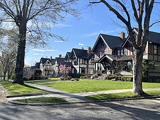
The Corbin Park Historic District is a 35-acre historic district in the Emerson/Garfield neighborhood of Spokane, Washington. The district has been listed on the National Register of Historic Places (NRHP) since 1992, and is listed on the state and local historic registers as well. It is made up of 87 buildings, 81 of which are considered to be contributing properties to the historic district. It is notable as one of the oldest intact neighborhoods in the city.