Ninth Avenue Historic District

Last updated

Ninth Avenue Historic District
Ninth Avenue Historic.jpg
Tudor Revival homes on Ninth Avenue
Location Map United States Spokane.png
Red pog.svg
USA Washington location map.svg
Red pog.svg
Usa edcp location map.svg
Red pog.svg
Location Cliff/Cannon, Spokane, Washington, United States
Coordinates 47°38′50.6″N117°26′05.6″W / 47.647389°N 117.434889°W / 47.647389; -117.434889
Area72 acres
Built1892-1940
ArchitectMultiple
Architectural style Queen Anne, Colonial Revival, Classical Revival, American Foursquare, Tudor Revival and Bungalow
NRHP reference No. 94000679
Added to NRHP1994

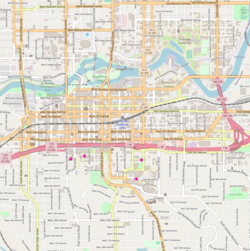
The Ninth Avenue Historic District is a National Register of Historic Places (NRHP) listed historic district located along and around Ninth Avenue in the Cliff/Cannon neighborhood of Spokane, Washington. It stretches from Monroe Street on the east to Chestnut Street on the west, running the length of Ninth Avenue and extending to include portions of Eighth, 10th and 11th Avenues, mostly in the western half of the district.

Contents

A residential area, the district was built to house many of early-Spokane's elite residents in grand Queen Anne, Colonial Revival, Classical Revival, American Foursquare and Tudor Revival homes, along with numerous Bungalow homes for middle-class residents. The area was developed largely between 1892 and 1940, with limited modern incursions in the form of apartments having been built in the decades since. It retains its residential character to this day, though many of the large single-family homes have been converted into multi-unit dwellings.

Located roughly one mile from the heart of Downtown Spokane, the Ninth Avenue Historic District is an example of an early residential development in Spokane, free of commercial incursions. Notable architects including Kirtland Cutter, Willis Ritchie, Julius Zittel, Loren L. Rand, John K. Dow and Albert Held designed homes in the district.

In the present day, the area is part of the Cliff/Cannon neighborhood of Spokane, stretching from the historic Cannon's Addition in the west over to Monroe Street, a major arterial extending from the north side of Spokane through downtown and up onto the South Hill, in the east. It makes up part of what is now known as the "lower South Hill" [1] for its location near the bottom of a hill which rises abruptly from the downtown area to the north. The terrain surrounding the Ninth Avenue Historic District falls off dramatically on the west to a valley containing Latah Creek, which marks a natural western boundary, and drops to the north to the valley of the Spokane River and Downtown Spokane in the north, while terrain rises to the west and south as one continues up into the South Hill residential area of Spokane. [2]

Setting

The Ninth Avenue Historic District is located, as the name implies, mostly along Ninth Avenue in the Cliff/Cannon neighborhood on Spokane's South Hill. It stretches from Monroe Street on the east, an arterial which connects the district with residential areas to the south of the district, to Downtown and the north side of the city beyond, [3] to Chestnut Street on the east where the South Hill falls off dramatically into the valley cut by Latah Creek and the Latah/Hangman neighborhood. The district also includes portions of Eighth Avenue between Monroe and Cedar Streets in the east and along Eighth Avenue between Elm and Chestnut Streets in the west, 10th Avenue between Cherry and Cannon Streets in the east, and 11th Avenue between Maple and Elm Streets in the east. [4] Aside from Monroe Street on the west and the couplet of Maple and Walnut Streets in the middle of the district, which are each major north-south thoroughfares, the roads in the district can be described as residential side-streets. [3]

The terrain within the district is mostly flat, though it trends higher as one heads east, but the surrounding terrain is considerably more varied. Immediately north of the district the elevation falls rapidly into the valley of the Spokane River and Downtown Spokane while the western edge of the district lies along a nearly 200 foot drop down to the valley of Latah Creek. Terrain gradually rises to the south and east, with a more dramatic rise in the east occurring just outside of the district beyond Monroe Street. [2]

Ninth and Maple showing the variety of trees in the district Ninth and Maple.jpg
Ninth and Maple showing the variety of trees in the district

Platted on a grid layout, streets in the district are almost entirely uniform in a north-south and east-west manner, though this grid breaks down just beyond the fringes of the district to the west and east as the terrain changes. It is well connected to neighboring parts of Spokane including downtown to the north and the rest of Cliff/Cannon and the South Hill to the south. [2]

The Ninth Avenue Historic District boasts a strong tree canopy of both planted deciduous street trees lining many of the area roads as well as trees planted or developed around on private property. Many properties contain vestige ponderosa pine or Douglas fir trees native to the area. [5] The basalt rock outcroppings around which these trees once grew have largely been built over in the district, though vestiges of the rock's presence can be seen as a building material in many of the homes and on outcroppings in adjacent areas. [5]

History

The area that is now the Ninth Avenue Historic District was inhabited by the Spokane people for centuries prior to American settlement. [6]

A.M. Cannon, an early settler and developer in the Spokane area who arrived in 1878, [7] platted the area west of Cedar Street to 10th Avenue in 1883. A decade later, during the Panic of 1893, Cannon lost all of his holdings, though his name remains prominent as it is in the official city neighborhood of Cliff/Cannon and on Cannon Street in the west of the district. [5]

Most of the construction in the district took place in the years between Cannon's plat in 1883 and 1920, with the most intense development occurring during the first decade of the 20th century. Spokane's population grew from roughly 30,000 people in 1900 to over 100,000 in 1910. It was during this decade that the city expanded from its original settlement location in what is now Downtown Spokane about a mile to the northeast of the district through Ninth Avenue and up the South Hill. [5] Development in the area was spurred by the establishment of streetcar trolley lines which provided transportation into the city center. [8]

Development of residential areas for the elites of Spokane had been limited largely to the Browne's Addition neighborhood in the city's formative decades of the late 1800s, but by the turn of the century new development was needed to match the pace of population growth. Ninth Avenue, along with other historic districts like the adjacent Marycliff-Cliff Park Historic District and the Corbin Park Historic District on the north side of town, was a beneficiary of this boom. Numerous notable local architects including Loren L. Rand, Willis A. Ritchie, Cutter and Malmgren, Albert Held, John K. Dow, and Julius Zittel worked to design homes in the district. [5]

Most of the grandest homes were built between 1905 and 1915 and housed some of Spokane's elite, including Mayor James Comstock, financier Alfred Coolidge, and businessman John Sengfelder — whose homes are each also listed on the Spokane Register of Historic Places. [9] [10] [11] Another resident of the district, J. Grier Long, hosted then-President Theodore Roosevelt during a visit to Spokane in 1908. [5] In addition to the wealthy elite of Spokane, the neighborhood housed numerous craftsmen and teachers, creating a varied socio-economic environment which persists to this day. [5]

Multi-unit house on Ninth Avenue Ninth Ave Multi-unit.jpg
Multi-unit house on Ninth Avenue

In the decades since the neighborhood's complete development, which ended in the early 1920s, there have been some changes to the historic district. Spokane's streetcar system was replaced with busses in 1936, though disused rails are still visible in some roads around the district. [12] Many of the formerly single-family homes have been converted into multi-unit dwellings, and some homes have been demolished to make way for modern apartments or condominiums. [13] In addition to being listed on the National Register of Historic Places in 1994, portions of the district were listed on the local Spokane Register of Historic Places in 2023 as the Cannon Hill Streetcar Historic District. [8]

See also

Related Research Articles

<span class="mw-page-title-main">Neighborhoods in Spokane, Washington</span>

Neighborhoods in Spokane, Washington are officially grouped by the Spokane City Council into three main city council districts: 1, 2, and 3. Each city council district contains multiple, official neighborhoods that are recognized with a neighborhood council. Informally, neighborhoods are colloquially grouped by local geographical, geological, cultural, or historical features The list of neighborhoods below is organized based on the official designations by the City of Spokane. Unofficial neighborhoods and districts are listed within the official neighborhood in which they are located.

<span class="mw-page-title-main">Downtown Spokane</span> Central business district of Spokane in Washington, United States

Downtown Spokane or Riverside is the central business district of Spokane, Washington. The Riverside neighborhood is roughly bounded by I-90 to the south, Division Street to the east, Monroe Street to the west and Boone Avenue to the north. The topography of Downtown Spokane is mostly flat except for areas downstream of the Spokane Falls which are located in a canyon; the elevation is approximately 1,900 feet (580 m) above sea level.

<span class="mw-page-title-main">West Central, Spokane</span> Neighborhood in Spokane, Washington, U.S.

West Central is a neighborhood in Spokane, Washington. As the name suggests it is located centrally on the west side of the city. Downtown Spokane is immediately east of the neighborhood, and spreads into West Central along Monroe Street in the Kendall Yards area. The neighborhood is diverse, with single and multi-family residential zones dating back to the early days of Spokane, a new mixed use development on the site of a former rail yard, the Spokane County Courthouse campus and associated government buildings and a few commercial districts. The Spokane River gorge winds around the southern and western edge of the neighborhood. It is home to Nettleton's Addition Historic District, which was added to the National Register of Historic Places in March 2006, and is also the largest historic district on the Washington State Heritage Register.

<span class="mw-page-title-main">Riverside Avenue Historic District</span> Historic district in Washington, United States

The Riverside Avenue Historic District is a 16.5 acres (6.7 ha) historic district in Downtown Spokane, Washington consisting of buildings constructed in the early 20th century, and was listed on the National Register of Historic Places in 1976. The listing includes 14 contributing properties, nine of which are considered primary and five are considered secondary.

<span class="mw-page-title-main">Browne's Addition, Spokane</span> Spokane Neighborhood in Washington, United States

Browne's Addition, often referred to shorthand as just Browne's, is a neighborhood in Spokane, Washington. It is located directly west of Downtown Spokane and is one of the oldest and densest neighborhoods in the city. The area is known for its numerous historic mansions, many of which have been converted into multi-family apartments. The terrain is flat in the neighborhood despite the degree of topographical relief in the immediate surrounding area. Latah Creek cuts a deep valley to the west, separating Browne's Addition from the Sunset Hill portion of the West Hills neighborhood and the Spokane River gorge drops off dramatically to the north into the Peaceful Valley neighborhood. The South Hill area of Spokane rises to the southwest.

<span class="mw-page-title-main">Peaceful Valley, Spokane</span> Spokane Neighborhood in Washington, United States

Peaceful Valley is a neighborhood in Spokane, Washington. It sits directly below Downtown Spokane on the Spokane River under its falls. The neighborhood snakes along the thin floodplain on the valley floor of the Spokane River Gorge. It is the smallest neighborhood in the city by both area and population, but due to its central location and unique character it is quite notable. The neighborhood has a working class and bohemian culture.

<span class="mw-page-title-main">Rockwood, Spokane</span> Spokane Neighborhood in Washington, United States

Rockwood is a neighborhood in Spokane, Washington. It is located on the south side of the city to the southeast of Downtown Spokane and expanding southeasterly from close to the city center. Its proximity to downtown makes it one of Spokane's older neighborhoods, with mature trees lining most of its streets. Due to its location on the hill leading up from the Spokane River Valley, the street grid breaks down in many places around Rockwood. The most notable of these is along the winding Rockwood Boulevard, which was designed by the Olmsted Brothers and weaves its way from the northwesternmost corner of the neighborhood through the center and across to the eastern border, highlighting the basalt bluffs and other natural topography.

<span class="mw-page-title-main">Manito/Cannon Hill, Spokane</span> Neighborhood in Spokane, Washington, United States

Manito/Cannon Hill is a neighborhood on the South Hill of Spokane, Washington. It is named after the two public parks that dominate its setting: Manito Park and Cannon Hill Park. Manito/Cannon Hill is a predominantly residential neighborhood made up mostly by single-family homes and city park land.

<span class="mw-page-title-main">Cliff/Cannon, Spokane</span> Neighborhood in Spokane, Washington, United States

Cliff/Cannon is a neighborhood in Spokane, Washington. It is located immediately south of Downtown, Spokane, and on the lower reaches of the broader South Hill. The neighborhood is home to a medical district with Sacred Heart and Deaconess both having their main hospital campuses along Cliff/Cannon's denser northern edge. To the south the neighborhood becomes more residential. City parks break up the residential zoning of the southern half of Cliff/Cannon. It is adjacent to the Cannon Hill area of the neighboring but separate Manito/Cannon Hill neighborhood. The Marycliff-Cliff Park Historic District, a National Historic District listed on the National Register of Historic Places, is located within the neighborhood.

<span class="mw-page-title-main">Latah/Hangman, Spokane</span> Spokane Neighborhood in Washington, United States

Latah/Hangman is a neighborhood in Spokane, Washington.

<span class="mw-page-title-main">Emerson/Garfield, Spokane</span> Spokane Neighborhood in Washington, United States

Emerson/Garfield is a neighborhood in Spokane, Washington. It is located immediately north of Downtown Spokane's North Bank and extends out into the inner northwestern portion of the city. Emerson/Garfield is a diverse neighborhood with residential, commercial and civic zones all bordering one another, with density ranging from single-family homes to multi-use buildings. Due to its location in the central area of Spokane, Emerson/Garfield is criss-crossed by numerous arterials and thoroughfares. Along those main roads are numerous commercial and retail districts of importance to both the neighborhood and city as a whole.

<span class="mw-page-title-main">Lincoln Heights, Spokane</span> Spokane Neighborhood in Washington, United States

Lincoln Heights is a neighborhood in Spokane, Washington. It is located in the southeastern portion of the city in a broader area commonly known as the South Hill. As the name suggests, Lincoln Heights lies on the slopes and atop the crest of the South Hill area. Lincoln Heights is home to a mix of single-family residential, multi-family residential, and commercial areas and a significant amount of park land. The Lincoln Heights Shopping Center and surrounding area is one of the largest and most important commercial and retail districts on the entire south side of Spokane.

<span class="mw-page-title-main">Comstock, Spokane</span> Neighborhood in Washington, United States

Comstock is a neighborhood in Spokane, Washington. It is located on the south side of the city in a broader area commonly known as the South Hill. The neighborhood is primarily single-family residential, and a mix of homes built during the streetcar era and then built during the post-World War II housing boom. The neighborhood is also home to a few commercial districts, including the regionally important Manito Shopping Center, two schools, the eponymous Comstock Park, sports fields and a golf course.

<span class="mw-page-title-main">Grandview/Thorpe, Spokane</span> Spokane Neighborhood in Washington, United States

Grandview/Thorpe is a neighborhood in Spokane, Washington. Located in southwestern Spokane, the neighborhood takes its name from two roads that pass through. Grandview Boulevard, so named because of its location at the top of a ridge from which large swaths of Spokane, the Spokane Valley and surrounding mountains to the north and east such as Mount Spokane, can be seen, is located in the northern part of the neighborhood. Thorpe Road traverses a gully in the central and southern portion of the neighborhood.

<span class="mw-page-title-main">North Hill, Spokane</span> Spokane Neighborhood in Washington, United States

North Hill is a neighborhood in Spokane, Washington. As the name suggests, it is atop a hill on the north side of Spokane, within which it is centrally located and crossed by numerous major thoroughfares. It is home to parks, commercial districts and single family residential areas. The historic Garland Theater is located in North Hill, and the city's main north–south arterial, Division Street, is home to a major commercial district along the eastern edge of the neighborhood.

<span class="mw-page-title-main">West Hills, Spokane</span> Spokane Neighborhood in Washington, United States

West Hills is a neighborhood in Spokane, Washington. As the name suggests, the neighborhood is located on hillsides to the west of downtown Spokane. The neighborhood also extends far to the west along the West Plains to incorporate the Spokane International Airport and surrounding land. As the city has grown over the decades, the West Hills neighborhood has expanded uphill and onto the plains to the west. That history of incremental growth, combined with the hilly topography of the area cut by numerous watercourses, has broken up the neighborhood into multiple, distinct areas with swaths of undeveloped land mixed in between.

<span class="mw-page-title-main">Glover Mansion</span> United States historic place

The Glover Mansion is a historic Tudor revival home built in 1888 and located in the Cliff/Cannon neighborhood of Spokane, Washington, just uphill from and overlooking the city's downtown. The home was designed by architect Kirtland Cutter for James N. Glover, who founded the city of Spokane in 1873. Over the years the Glover Mansion has served as a residence, housed Spokane's Unitarian Universalist Church, and more recently been used as an event venue.

<span class="mw-page-title-main">Marycliff-Cliff Park Historic District</span> United States historic place

The Marycliff-Cliff Park Historic District is a historic residential area in the Cliff/Cannon neighborhood of Spokane, Washington, located immediately uphill from the city's downtown core, listed on the National Register of Historic Places (NRHP). The district is made up of two distinct but connected areas, the Marycliff section located at the base of a basalt cliff and south of Seventh Avenue, and the Cliff Park section located atop the cliff and north of 14th Avenue. Encroachment from the nearby city center has changed the nature of the Marycliff section over the decades. Of the palatial homes built in the late 1800s in the area, all have either been converted to commercial or public use or razed to make way for new development, though there are still a number of properties that are intact and reflect the historic nature of the area. The Cliff Park section retains its original residential character and historic nature, with only 11 properties listed as intrusive among the 118 properties in the area.

<span class="mw-page-title-main">Rockwood Historic District</span> Historic district in Spokane, Washington

The Rockwood Historic District is a historic residential area in the Rockwood neighborhood on the south side of Spokane, Washington. The district was listed on the National Register of Historic Places (NRHP) in 1997 due to the concentration of historic homes within the district as well as its significance in the areas of architecture, landscape architecture, and community planning and development.

<span class="mw-page-title-main">Nettleton's Addition Historic District</span> Historic district in Spokane, Washington

The Nettleton's Addition Historic District is a historic residential district in the West Central neighborhood of Spokane, Washington. It was listed on the National Register of Historic Places (NRHP) in 2006 because of the concentration of historic homes in one of Spokane's oldest residential neighborhoods and for its significance as an example of community planning and development and in the area of architecture. It is the largest national historic district in the state of Washington.

References

  1. Holm, Samantha (October 13, 2022). "The Cliff/Cannon neighborhood on Spokane's lower South Hill could get historic protections — if homeowners want it". The Inlander. Retrieved April 14, 2024.
  2. 1 2 3 "Spokane NW Quadrangle" (Topographical Map). usgs.gov. United States Geological Survey. 2023. Retrieved April 14, 2024.
  3. 1 2 "Official Arterial Street Map" (PDF). spokanecity.org. City of Spokane. Retrieved April 14, 2024.
  4. "Ninth Avenue" (PDF). historicspokane.org. City of Spokane. Retrieved April 14, 2024.
  5. 1 2 3 4 5 6 7 Thompson, Mary (May 18, 1994). "National Register of Historic Places Registration Form" (PDF). nps.gov. National Park Service. Retrieved April 14, 2024.
  6. "History". spokanetribe.com. Spokane Tribe of Indians. Retrieved April 14, 2024.
  7. Sadlo, Adrienne. "The Original Cabin and Mansion of A.M. Cannon". spokanehistorical.org. Eastern Washington University. Retrieved April 14, 2024.
  8. 1 2 Dinman, Emry (March 7, 2023). "Spokane City Council creates Cannon Hill Streetcar Historic District". The Spokesman-Review. Retrieved April 14, 2024.
  9. "Comstock House". historicspokane.org. City - County of Spokane Historic Preservation Office. Retrieved April 14, 2024.
  10. "Coolidge-Rising-Moyer House". historicspokane.org. City - County of Spokane Historic Preservation Office. Retrieved April 14, 2024.
  11. "Sengfelder-Bungay House". historicspokane.org. City - County of Spokane Historic Preservation Office. Retrieved April 14, 2024.
  12. Kershner, Jim (January 25, 2007). "Spokane's Streetcars". historylink.org. Washington State Department of Archeology and Historic Preservation. Retrieved April 14, 2024.
  13. Deshais, Nicholas (December 26, 2017). "New apartment building will take place of three old homes in historic South Hill neighborhood". The Spokesman-Review. Retrieved April 14, 2024.