Clio, Alabama

Last updated

Clio
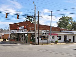
Clio, Alabama.JPG
Flag of Clio, Alabama.png
Seal of Clio, Alabama.png
Barbour County Alabama Incorporated and Unincorporated areas Clio Highlighted 0115640.svg
Location of Clio in Barbour County, Alabama.
Coordinates: 31°42′35″N85°36′24″W / 31.70972°N 85.60667°W / 31.70972; -85.60667
Country United States
State Alabama
County Barbour
Area
[1]
  Total10.08 sq mi (26.09 km2)
  Land10.07 sq mi (26.07 km2)
  Water0.01 sq mi (0.02 km2)
Elevation
525 ft (160 m)
Population
 (2020)
  Total1,220
  Density121.20/sq mi (46.80/km2)
Time zone UTC-6 (Central (CST))
  Summer (DST) UTC-5 (CDT)
ZIP code
36017
Area code 334
FIPS code 01-15640
GNIS feature ID0157921

Clio is a city [2] in Barbour County, Alabama, United States. The population was 1,399 at the 2010 census, [3] down from 2,206 in 2000, at which time it was a town. It is the birthplace of former Alabama governor George C. Wallace, as well as Baseball Hall of Famer and former Atlanta Braves broadcaster Don Sutton.

Contents

Geography

According to the U.S. Census Bureau, the city has a total area of 10.1 square miles (26.1 km2), of which 0.008 square miles (0.02 km2), or 0.09%, is water. [3]

The center of Clio lies at the intersection of Alabama State Routes 10 and 51. Highway 10 leads west 13 miles to Brundidge and east 7 miles to Blue Springs. Highway 51 leads 11 miles south to Ariton and north 7 miles to Louisville and 16 miles to the county seat of Clayton.

Demographics

Historical population
CensusPop.Note
1900 326
1910 58077.9%
1920 83844.5%
1930 8673.5%
1940 841−3.0%
1950 840−0.1%
1960 92910.6%
1970 1,06514.6%
1980 1,22414.9%
1990 1,36511.5%
2000 2,20661.6%
2010 1,399−36.6%
2020 1,220−12.8%
U.S. Decennial Census [4]
2013 Estimate [5]

2020 census

Clio racial composition [6]
RaceNum.Perc.
White (non-Hispanic)24620.16%
Black or African American (non-Hispanic)46638.2%
Asian 80.66%
Other/Mixed 292.38%
Hispanic or Latino 47138.61%

As of the 2020 United States census, there were 1,220 people, 442 households, and 238 families residing in the city.

2010 census

As of the census [7] of 2010, there were 1,399 people, 514 households, and 321 families residing in the town. The population density was 139 inhabitants per square mile (54/km2). There were 634 housing units at an average density of 62.7 per square mile (24.2/km2). The racial makeup of the town was 36.5% Black or African American, 32.0% White, 0.4% Native American, 0.5% Asian, 0.1% Pacific Islander, 30.2% from other races, and .4% from two or more races. 36.0% of the population were Hispanic or Latino of any race.

There were 514 households, out of which 28.8% had children under the age of 18 living with them, 35.4% were married couples living together, 19.8% had a female householder with no husband present, and 37.5% were non-families. 30.9% of all households were made up of individuals, and 12.7% had someone living alone who was 65 years of age or older. The average household size was 2.72 and the average family size was 3.37.

In the town the population was spread out, with 26.2% under the age of 18, 12.9% from 18 to 24, 26.6% from 25 to 44, 22.4% from 45 to 64, and 11.8% who were 65 years of age or older. The median age was 31.8 years. For every 100 females, there were 95.7 males. For every 100 females age 18 and over, there were 85.4 males.

The median income for a household in the town was $21,806, and the median income for a family was $33,438. Males had a median income of $32,908 versus $25,625 for females. The per capita income for the town was $8,722. About 28.3% of families and 28.0% of the population were below the poverty line, including 33.1% of those under age 18 and 19.1% of those age 65 or over.
Notable people

Points of interest

Related Research Articles

<span class="mw-page-title-main">Louisville, Alabama</span> Town in Alabama, United States

Louisville is a town in Barbour County, Alabama, United States. The population was 395 as of the 2020 census.

<span class="mw-page-title-main">Heflin, Alabama</span> City in Alabama, United States

Heflin is a city and the county seat of Cleburne County, Alabama, United States. At the 2020 census, the population was 3,431. It is located approximately halfway between Birmingham and Atlanta along Interstate 20.

<span class="mw-page-title-main">New Brockton, Alabama</span> Town in Alabama, United States

New Brockton is a town in Coffee County, Alabama, United States. At the 2020 census, the population was 1,428. The community was named for Huey E. Brock, a settler who came to the region in 1871.

<span class="mw-page-title-main">Clayhatchee, Alabama</span> Town in Alabama, United States

Clayhatchee is a town in Dale County, Alabama, United States. At the 2010 census the population was 589, up from 501 in 2000. It was incorporated in April 1967. It is part of the Ozark Micropolitan Statistical Area.

<span class="mw-page-title-main">Grimes, Alabama</span> Town in Alabama, United States

Grimes is a town in Dale County, Alabama, United States. At the 2010 census the population was 558, up from 459 in 2000. It is part of the Enterprise–Ozark Micropolitan Statistical Area.

<span class="mw-page-title-main">Lakeview, Alabama</span> Town in Alabama, United States

Lakeview is a town in DeKalb County, Alabama, United States. At the 2020 census, the population was 161. Lakeview is located atop Sand Mountain.

<span class="mw-page-title-main">Powell, Alabama</span> Town in Alabama, United States

Powell is a town in DeKalb County, Alabama, United States. At the 2020 census, the population was 901. Powell is located atop Sand Mountain.

<span class="mw-page-title-main">Sylvania, Alabama</span> Town in Alabama, United States

Sylvania is a town in DeKalb County, Alabama, United States. It incorporated in October 1967. At the 2010 census the population was 1,837, up from 1,186 in 2000. Sylvania is located atop Sand Mountain. Sylvania was incorporated in 1967. The post office /town hall was built in 1977.

<span class="mw-page-title-main">Coffee Springs, Alabama</span> Town in Alabama, United States

Coffee Springs is a town in Geneva County, Alabama, United States. It was incorporated in 1900, and it is considered to be a part of the Dothan, Alabama Metropolitan Statistical Area. At the 2010 census the population was 228, down from 251.

<span class="mw-page-title-main">Malvern, Alabama</span> Town in Alabama, United States

Malvern is a town in Geneva County, Alabama, United States. It is part of the Dothan, Alabama Metropolitan Statistical Area. At the 2010 census the population was 1,448, up from 1,215 in 2000.

<span class="mw-page-title-main">Taylor, Alabama</span> Town in Alabama, United States

Taylor is a town in Geneva and Houston counties in the U.S. state of Alabama. Taylor was first settled in the 1870s, named after an early family that helped secure the first post office. It was not incorporated until almost a century later in June 1967. It is part of the Dothan, Alabama Metropolitan Statistical Area. At the 2010 census the population was 2,375, up from 1,898 in 2000.

<span class="mw-page-title-main">Avon, Alabama</span> Town in Alabama, United States

Avon is a town in Houston County, Alabama, United States. It incorporated in January 1957. It is part of the Dothan, Alabama Metropolitan Statistical Area. As of the 2010 census, the population of the town was 543, its highest to date, up from 466 in 2000.

<span class="mw-page-title-main">Cottonwood, Alabama</span> Town in Alabama, United States

Cottonwood is a town in Houston County, Alabama, United States. One source said the town incorporated in 1901, although the 1910 U.S. Census stated 1903. It is part of the Dothan, Alabama Metropolitan Statistical Area. At the 2010 census the population was 1,289, up from 1,170 in 2000. The area was heavily damaged by an EF2 tornado on January 9, 2024. One person was killed and five others were injured.

<span class="mw-page-title-main">Cowarts, Alabama</span> Town in Alabama, United States

Cowarts is a town in Houston County, Alabama, United States. The town incorporated in August 1961. It is part of the Dothan, Alabama Metropolitan Statistical Area. At the 2010 census the population was 1,871, up from 1,546 in 2000.

<span class="mw-page-title-main">Gordon, Alabama</span> Town in Alabama, United States

Gordon is a town in Houston County, Alabama, United States. It was incorporated in February 1872. It is part of the Dothan, Alabama Metropolitan Statistical Area. At the 2010 census the population was 332, down from 408 in 2000.

<span class="mw-page-title-main">Kinsey, Alabama</span> Town in the United States

Kinsey is a town in Houston County, Alabama, United States. It was initially located and incorporated in Henry County in February 1893. In 1903, it was redrawn into newly created Houston County and was later reincorporated in August 1957. It is part of the Dothan, Alabama Metropolitan Statistical Area. At the 2010 census the population was 2,198, up from 1,796 in 2000.

<span class="mw-page-title-main">Rehobeth, Alabama</span> Town of the State of Alabama in the United States

Rehobeth is a town in Houston County, Alabama, United States. Rehobeth, originally named Sanders, began as a crossroads community in the 1890s; however, it was not until 1996, that the town was incorporated. Rehobeth is part of the Dothan Metropolitan Statistical Area. At the time of the 2010 census, the population was 1,297, up from 993 at the 2000 census.

<span class="mw-page-title-main">Webb, Alabama</span> Town in Alabama, United States

Webb is a town in Houston County, Alabama, United States. It is named for plantation owner B. F. Webb, who settled in the area around 1890. The town was incorporated in 1903. It is part of the Dothan, Alabama Metropolitan Statistical Area. As of the 2010 census, the population was 1,430, up from 1,298 in 2000.

<span class="mw-page-title-main">Town Creek, Alabama</span> Town in Alabama, United States

Town Creek is a town in Lawrence County, Alabama, United States, and is included in the Decatur Metropolitan Area, as well as the Huntsville-Decatur Combined Statistical Area. It incorporated in March 1875. As of the 2010 census, the population of the town is 1100, down from 1216 in 2000. Since 1920, it has been the second largest town in Lawrence County after Moulton.

<span class="mw-page-title-main">Level Park–Oak Park, Michigan</span> Census-designated place & unincorporated community in Michigan, United States

Level Park–Oak Park is a census-designated place for statistical purposes in Calhoun County in the U.S. state of Michigan. The CDP population was 3,260 at the 2020 census. The CDP is immediately northwest of the city of Battle Creek and is part of the Battle Creek Metropolitan Statistical Area.

References

  1. "2020 U.S. Gazetteer Files". United States Census Bureau. Retrieved October 29, 2021.
  2. U.S. Census change list Archived August 6, 2010, at the Wayback Machine
  3. 1 2 "Geographic Identifiers: 2010 Demographic Profile Data (G001): Clio city, Alabama". U.S. Census Bureau, American Factfinder. Archived from the original on February 12, 2020. Retrieved September 16, 2013.
  4. "U.S. Decennial Census". Census.gov. Retrieved June 6, 2013.
  5. "Annual Estimates of the Resident Population: April 1, 2010 to July 1, 2013" . Retrieved June 3, 2014.
  6. "Explore Census Data". data.census.gov. Retrieved December 13, 2021.
  7. "U.S. Census website". United States Census Bureau . Retrieved January 31, 2008.

31°42′36″N85°36′24″W / 31.709922°N 85.606708°W / 31.709922; -85.606708