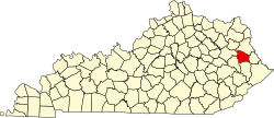
Collista, Kentucky

Last updated

Collista, Kentucky
USA Kentucky location map.svg
Red pog.svg
Collista
Usa edcp location map.svg
Red pog.svg
Collista
Coordinates: 37°46′57″N82°49′28″W / 37.78250°N 82.82444°W / 37.78250; -82.82444
Country United States
State Kentucky
County Johnson
Time zone UTC-5 (Eastern (EST))
  Summer (DST) UTC-4 (EDT)
ZIP codes
41222

Collista is an unincorporated community in Johnson County, Kentucky, United States, located along U.S. Route 23 and Jenny's Creek. Its ZIP code is 41222. [1]

Related Research Articles

<span class="mw-page-title-main">ZIP Code</span> Numeric postal code used in the United States and its territories

A ZIP Code is a system of postal codes used by the United States Postal Service (USPS). Introduced on July 1, 1963, the basic format consisted of five digits. In 1983, an extended ZIP+4 code was introduced; it included the five digits of the ZIP Code, followed by a hyphen and four digits that designated a more specific location.

<span class="mw-page-title-main">Johnson Valley, California</span> Unincorporated community in California, United States

Johnson Valley is a small unincorporated community in San Bernardino County in Southern California between Victor Valley and Morongo Basin areas of the High Desert region of California. It is north of Highway 247 in the Mojave Desert, and north by northwest of Yucca Valley. It is bordered by the San Bernardino Mountains to the south, Lucerne Valley to the west, and Landers to the east.

Hager Hill (also Hagerhill) is an unincorporated community in Johnson County, Kentucky, United States. Hager Hill is located approximately four miles south of Paintsville, the county seat of Johnson County.

Oil Springs is an unincorporated community in Johnson County, Kentucky, United States. It lies along Route 40 west of the city of Paintsville, the county seat of Johnson County. It has a post office with the ZIP code 41238.

West Van Lear is an unincorporated community in Johnson County, Kentucky, United States. Even though it is unincorporated, it has a post office and its own ZIP code (41268). It has a small grocery store, a volunteer fire department, and a community center.

<span class="mw-page-title-main">Pearson, Wisconsin</span> Unincorporated community in Wisconsin, United States

Pearson is an unincorporated community in the town of Ainsworth, Langlade County, Wisconsin, United States. Pearson is 5 miles (8 km) west of Pickerel and 17 miles (27 km) north-northeast of Antigo, the county seat of Langlade County. The community is situated on Pickerel Creek near its confluence with the Wolf River. County Highway T runs through Pearson; the closest state highway to the community is Wisconsin State Highway 55 in Pickerel. Pearson had a post office, which closed on May 4, 1996; ZIP code 54462 still serves the community. The Northeast Illinois Council of the Boy Scouts of America runs a summer camp, Ma-Ka-Ja-Wan Scout Reservation, in Pearson. The Pickerel Volunteer Fire Department Station is located east of the community on Johnson Road.

Wittensville is an unincorporated community in Johnson County, Kentucky, United States. Wittensville's ZIP code is 41274. It has a United States Postal Service, which stands besides a Dollar General which was constructed in June 2019. It also has an East Kentucky Realty estate agency.

<span class="mw-page-title-main">Meally, Kentucky</span> Unincorporated community in Kentucky, United States

Meally is an unincorporated community in Johnson County, Kentucky, United States. The community's ZIP code is 41234. Meally is located at an elevation of 620 feet (189 m).

Pendleton is an unincorporated community in Bell County, Texas, United States. Pendleton has a post office with the ZIP code 76564. The community was the birthplace of acclaimed blues musician Blind Willie Johnson and Green Bay Packers Pro Football Hall of Famer Bobby Dillon.

Volga is an unincorporated community in Johnson County, Kentucky, United States. Its ZIP Code is 41219. Volga is located at an elevation of 718 feet.

Nippa is an unincorporated community in Johnson County, Kentucky, United States. It is located at an elevation of 636 feet. Nippa is located in the ZIP Code Tabulation Area for ZIP code 41240.

Fuget is an unincorporated community in Johnson County, Kentucky, United States. Fuget is located at an elevation of 823 feet. It is located in the ZIP Code Tabulation Area for ZIP code 41219.

Winifred is an unincorporated community in Johnson County, Kentucky, United States. It is located at an elevation of 840 feet. Winifred is located in the ZIP Code Tabulation Area for ZIP code 41219, which includes the nearby community of Flat Gap.

Odds is an unincorporated community in Johnson County, Kentucky, United States. It is located at an elevation of 640 feet. Odds is located in the ZIP Code Tabulation Area for ZIP code 41265.

Elna is an unincorporated community in Johnson County, Kentucky, United States. It is located at an elevation of 876 feet. Elna is located in the ZIP Code Tabulation Area for ZIP code 41219.

Nero is an unincorporated community in Johnson County, Kentucky, United States. It is located at an elevation of 628 feet. Nero is located in the ZIP Code Tabulation Area for ZIP code 41265.

Hargis is an unincorporated community in Johnson County, Kentucky, United States. It is located at an elevation of 915 feet. It is located in the ZIP Code Tabulation Area (ZCTA) for ZIP code 41238.

Kimberlin Heights is an unincorporated community in southeast Knox County, Tennessee. It is the location of Johnson University and SNMP Research International.

Johnson is a hamlet in Orange County, New York, United States. The community is located near New York State Route 284 and is 7 miles (11 km) southwest of Middletown. Johnson has a post office with ZIP code 10933.

References

  1. "Johnson County, KY ZIP Code Maps".