
Watertown is a city in Middlesex County, Massachusetts, part of Greater Boston. The population was 35,329 in the 2020 census. Its neighborhoods include Bemis, Coolidge Square, East Watertown, Watertown Square, and the West End.

Mount Auburn Cemetery, located in Cambridge, Massachusetts, is the first rural or garden cemetery in the United States. It is the burial site of many prominent Boston Brahmins, and is a National Historic Landmark.

Harvard Square is a triangular plaza at the intersection of Massachusetts Avenue, Brattle Street and John F. Kennedy Street near the center of Cambridge, Massachusetts, United States. The term "Harvard Square" is also used to delineate the business district and Harvard University surrounding that intersection, which is the historic center of Cambridge. Adjacent to Harvard Yard, the historic heart of Harvard University, the Square functions as a commercial center for Harvard students, as well as residents of western Cambridge, the western and northern neighborhoods and the inner suburbs of Boston. The Square is served by Harvard station, a major MBTA Red Line subway and a bus transportation hub.

The Edmund Fowle House is a historic house and local history museum at 28 Marshall Street in Watertown, Massachusetts, USA. Built in 1772, it is the second-oldest surviving house in Watertown, and served as the meeting place for the Massachusetts Provincial Congress in the first year of the American Revolutionary War. Now owned by the local historic society, it was listed on the National Register of Historic Places in 1977.
The Rumney Marsh Burying Ground is a historic cemetery on Butler Street between Elm and Bixby Streets in Revere, Massachusetts. It was added to the National Register of Historic Places in 2004. It was the first burying ground of an area that now encompasses Revere as well as neighboring Chelsea and Winthrop.

The Cambridge Common Historic District is a historic district encompassing one of the oldest parts of Cambridge, Massachusetts. It is centered on the Cambridge Common, which was a center of civic activity in Cambridge after its founding in 1631. It was the site of the election for governor of the Massachusetts Bay Colony in 1636, and was a military barracks site during the American Revolutionary War. The common was gradually reduced in size to its present roughly triangular shape, and surrounded by buildings in the 18th and 19th centuries. In 1973 a historic district encompassing the extant common and everything within 100 feet (30 m) of it was listed on the National Register of Historic Places. In 1987 the district was amended to rationalize the boundary, which overlapped adjacent districts and included portions of some buildings.

Mount Wollaston Cemetery is a historic rural cemetery at 20 Sea Street in the Merrymount neighborhood of Quincy, Massachusetts. It was founded in 1855 and added to the National Register of Historic Places in 1984.
Mount Pleasant Cemetery is an historic cemetery at Crocker, Cohannet, and Barnum Streets in Taunton, Massachusetts. Opened in 1836, but based on a family burial ground dating to the early 18th century, it is the fourth garden cemetery in the U.S. rural cemeteries, based on the early Victorian model of Mount Auburn Cemetery in Cambridge, Massachusetts. The cemetery was listed on the National Register of Historic Places in 2002.

Hubbardston Town Common Historic District encompasses the town common of Hubbardston, Massachusetts, the adjacent 1773 First Parish Church, and the town's first burying ground. It has been the center of the town's civic and religious life since its incorporation in the 1760s, and was listed on the National Register of Historic Places in 2000. The district was named as one of the 1,000 Places to Visit in Massachusetts by the Great Places in Massachusetts Commission.

The Upper Historic District is a historic district encompassing the historic center of Washington, Massachusetts. Centered on the junction of Washington Mountain Road and Branch Road, the town center flourished from the town's establishment in the 1750s until the center of the town's business moved closer to the newly lain railroad in the 1830s. The district includes the old town hall, cemetery, common, and pound, as well as a number of residences. A meeting house (church) and schoolhouse once stood in the area, but the 1792 church was destroyed by lightning in 1859, and the schoolhouse is no longer extant. The district was added to the National Register of Historic Places in 1987.

The Ludlow Center Historic District encompasses the historic village center of Ludlow, Massachusetts. Centered on the junction of Center, Church and Booth Streets, it is the site selected as the town center when Ludlow was established in 1774. Its notable structures include the Congregational Church, the old town hall, and a number of farmhouses that date to the first half of the 19th century. The area has remained a center of civic life in the town, even though its economic center moved later in the 19th century to Ludlow Village. The district was listed on the National Register of Historic Places in 1988.

The Common Historic District is a historic district encompassing the civic and institutional heart of Reading, Massachusetts. The district is centered on the town common, at the intersection of Main and Salem Streets. The common has been communally owned since at least 1737, with the original burying ground to the north. In 1769 the area's first meeting house was built, giving the area a sense of identity separate from portions of Reading that would later be set off as Wakefield and North Reading. Since then the area has become a focal point for religious and civic institutions in the town.

Mount Feake Cemetery is a historic cemetery at 203 Prospect Street in Waltham, Massachusetts.

The Old Burying Ground is a historic cemetery on Pleasant and William Streets in Stoneham, Massachusetts. Established in 1726, it is the only surviving element of Stoneham's original town center, which also included a meeting house and school. It contains about 450 stones and fragments, with grave markers dating from 1728 to 1924. The stones were carved with motifs that were fairly typical of the period including urns, willows, cherubs, and winged death heads.

The Brookline Town Green Historic District encompasses the historic colonial heart of the town of Brookline, Massachusetts. Centered on a stretch of Walnut Street between Warren and Chestnut Streets, this area is where the town's first colonial meeting house and cemetery were laid out, and was its center of civic life until the early 19th century. The district was listed on the National Register of Historic Places in 1980.

The Second Rindge Meetinghouse, Horsesheds and Cemetery is a historic meeting house and cemetery on Old US 202 and Rindge Common in Rindge, New Hampshire. Built in 1796, it is relatively distinctive in New England as one of few such meeting houses where both civic and religious functions are still accommodated, housing both the town offices and a church congregation. The town's first cemetery, established in 1764, lies to the north of the meetinghouse. It is the resting place of many of Rindge's early settlers, and of its American Revolutionary War veterans. Behind the meetinghouse stand a row of horse sheds, the only one of the two rows of them which originally served the meetinghouse. The property was listed on the National Register of Historic Places in 1979.

Brattle Street in Cambridge, Massachusetts, called the "King's Highway" or "Tory Row" before the American Revolutionary War, is the site of many buildings of historical interest, including the modernist glass-and-concrete building that housed the Design Research store, and a Georgian mansion where George Washington and Henry Wadsworth Longfellow both lived, as well as John Vassall and his seven slaves including Darby Vassall. Samuel Atkins Eliot, writing in 1913 about the seven Colonial mansions of Brattle Street's "Tory Row," called the area "not only one of the most beautiful but also one of the most historic streets in America." "As a fashionable address it is doubtful if any other residential street in this country has enjoyed such long and uninterrupted prestige."

The Plainfield Center Historic District encompasses the historic rural village center of Plainfield, Massachusetts. The district is centered on a stretch of Main Street, between Church Lane and Central Street, and includes the town's oldest surviving houses, and its congregational church, set on the site of its first colonial-era meeting house, as well as the town hall (1847) and library (1925). The district was listed on the National Register of Historic Places in 2015.

The Middle Cemetery is an historic cemetery on Main Street in southern Lancaster, Massachusetts. Established in 1798, it is the town's third oldest cemetery, with active burials taking place until 1969. The cemetery was listed on the National Register of Historic Places in 2019.
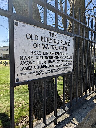
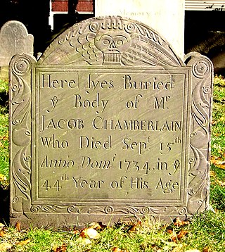
The Old Burying Ground is the oldest documented cemetery in Watertown, Massachusetts, United States. Located at the junction of Arlington and Mount Auburn Streets in eastern Watertown, its oldest documented grave site dates to 1665, and it remained in active use into the 20th century. It was the town's first formal cemetery, and remained its only one until 1754, when the Common Street Cemetery was established. The cemetery was listed on the National Register of Historic Places in 2022.


