
North Attleborough, alternatively spelled North Attleboro, is a city in Bristol County, Massachusetts, United States. The population was 30,834 at the 2020 United States Census.
Newton Upper Falls is one of the thirteen villages within the city of Newton in Massachusetts, United States. The village is listed as the Newton Upper Falls Historic District on the National Register of Historic Places.

The Dorchester-Milton Lower Mills Industrial District is a historic district on both sides of the Neponset River in the Dorchester area of Boston and in the town of Milton, Massachusetts. It encompasses an industrial factory complex, most of which was historically associated with the Walter Baker & Company, the first major maker of chocolate products in the United States. The industrial buildings of the district were built between about 1868 and 1947. They were listed as part of the district on the National Register of Historic Places in 1980, with a slight enlargement in 2001. The buildings have been adapted for mixed industrial/retail/residential use.

The Blake and Knowles Steam Pump Company National Register District encompasses the historical industrial complex of the Blake and Knowles Steam Pump Company and its successor, the Worthington Pump and Machinery Corporation in East Cambridge, Massachusetts. It is located in a one-block area surrounded by Third, Rogers, Binney, and Fifth Streets. The property was developed by the Blake and Knowles Steam Pump Company, one of the nation's leading manufacturer of industrial pumps from the late 19th century into the mid-20th century. The district was listed on the National Register of Historic Places in 1997.

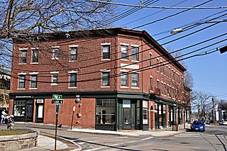
The North Attleborough Town Center Historic District encompasses the most historic elements of the central business district of North Attleborough, Massachusetts. The area was developed between about 1860 and 1830 as a center serving the community and the surrounding jewelry manufacturing businesses for which the town was well known. The district, extending along Washington Street between Fisher Street and Bruce Avenue, was added to the National Register of Historic Places in 1985.

The South Washington Street Historic District is a historic district encompassing 200 years of residential architecture in North Attleborough, Massachusetts. It extends along South Washington Street in the central portion of the town, between Elm Street in the north, and Sutherland Street in the south and includes two properties on Hunking Street. The district was added to the National Register of Historic Places in 1995.
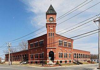
The H.F. Barrows Manufacturing Company Building, now the North Attleborough Police Station, is a historic industrial building in North Attleborough, Massachusetts. The elegant brick building was built in 1905–06, and was home for many years to one of the town's most successful jewelry businesses. It was listed on the National Register of Historic Places in 2001. Today the building serves as the headquarters for the North Attleborough Police Department.

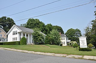
The Towne Street Historic District is a historic district on Towne Street, east of Jackson Street in North Attleborough, Massachusetts. Included in the district are numbers 224, 240, 251, and 260 Towne Street. It encompasses a collection of widely spaced rural-suburban houses built in the middle decades of the 19th century. The district was added to the National Register of Historic Places in 2003.

The Old Town Historic District is a historic district in North Attleborough, Massachusetts, which encompasses the historic early town center of Attleboro, which it was originally a part of. It was here that Attleboro's first church was built, and its militia training ground was laid out. The district retains 18th-century vestiges of this early history, and was largely bypassed by 19th-century industrialization. The district was added to the National Register of Historic Places in 1991.
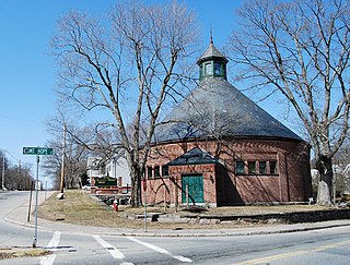
The Attleborough Falls Gasholder Building is a historic industrial building at 380 Elm Street in North Attleborough, Massachusetts. It is a rare surviving example of a mid-19th century gasholder house. The brick structure originally housed a tank in which coal gas was stored. It was listed on the National Register of Historic Places in 1996.

The Attleborough Falls Historic District is a predominantly residential historic district on Mt. Hope and Towne Streets in North Attleborough, Massachusetts. Located just south of the Ten Mile River, it encompasses a stylish mid-to-late 19th century residential area that developed in a previously rural area due to industrial development across the river. The district was added to the National Register of Historic Places in 2004.

The Cottage–Freeman Historic District is a historic district on Cottage St. Freeman St., from Commonwealth Ave. to Ten Mile River and Park Lane in North Attleborough, Massachusetts. It encompasses a densely populated neighborhood which was developed predominantly in the two decades beginning c. 1890, built to house workers in the area's jewelry industry. Most of it consists of vernacular architecture of the period, although there are some houses which date to the early 19th century.
The High, Church and Gould Streets Historic District is a historic district at 56-60-122 High Street, 29-117 Church Street, and 9-17 Gould Street in North Attleborough, Massachusetts. This area was developed in the mid to late 19th century as a residential area serving businessmen and professionals, predominantly those associated with North Attleborough's dominant jewelry industry. Its first main phase of growth was between about 1832 and 1855, and it experienced its most significant growth after the American Civil War and the arrival of the railroad.

The Freeman's Grove Historic District is a residential historic district in North Adams, Massachusetts. It encompasses a neighborhood north of the city center that is a well-preserved instance of a working class area developed during its industrial heyday in the late 19th century. It includes the Chase Hill Estate as well as all the houses on Chase Avenue, Bracewell Street, Hall Street and several smaller streets adjacent to those. It is roughly bounded by Liberty Street, Eagle Street, Bracewell Avenues and Houghton Street. The district was listed on the National Register of Historic Places in 1985.

The Ware Millyard Historic District encompasses a 19th-century mill complex and industrial mill village in the town of Ware, Massachusetts. It is roughly bounded by South Street, the Ware River, Upper Dam Complex, Park Street, Otis Avenue and Church Street. The area includes surviving mill buildings, the oldest of which date to the 1840s, and a collection of tenement-style housing built for the millworkers, built between 1845 and the 1880s.

The Springfield Street Historic District is a predominantly residential historic district south of the downtown area of Chicopee, Massachusetts. It encompasses a significant number of Queen Anne style houses built in the second half of the 19th century by wealthy residents of Chicopee, as well as housing for skilled workers at the nearby textile mills. It is centered where Springfield Street and Fairview Avenue meet. The district was listed on the National Register of Historic Places in 1991.

The Central Square Historic District is a historic district encompassing much of the central business district of Stoneham, Massachusetts. It includes the town's largest concentration of 19th and early-20th century commercial architecture, in an area that developed in importance as a commercial center after the construction of the Andover-Medford Turnpike. The district was added to the National Register of Historic Places in 1990.

The Harding-Winter Street Manufacturing District encompasses a surviving fragment of the 19th century industrial history of Worcester, Massachusetts. The district includes seven brick factory buildings which were built between 1870 and 1898. They are a remnant of a once-extensive manufacturing district that extended further along Franklin and Grafton Streets, but has become fragmented by urban redevelopment and the construction of nearby Interstate 290. The district is bounded on the south by Pond Street, on the west by Harding Street, on the east by Water Street, and on the north by the rear property lines of Winter Street properties. The district was listed on the National Register of Historic Places in 1980.

The Saco–Pettee Machine Shops is a historic factory complex at 156 Oak Street in the Newton Upper Falls area of Newton, Massachusetts. Although the area has an industrial history dating to the early 19th century, the oldest buildings in this complex, consisting of about thirteen brick buildings, were built in 1892. The property, a major economic force in the development of Newton Upper Falls, was listed on the National Register of Historic Places in 1986. It was home to Clark's N.A., the North American home base to Clark's Shoes, makers of fine footwear, until they relocated to Waltham Ma. in October 2016.
The West Main Street Historic District of Marlborough, Massachusetts encompasses a residential area west of the city center. It extends along West Main Street from Mechanic Street to Gibbon Street, along Pleasant Street from West Main to Lincoln Street, and also includes short pieces of Witherbee and Winthrop Streets abutting West Main. Most of the buildings in the district are houses built between 1820 and 1930, the period of the city's growth as an industrial center. The 15-acre (6.1 ha) district includes 77 properties, all but two of which contribute to its historic significance. The district was listed on the National Register of Historic Places in 2001.


