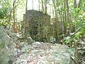
Cooper Bay ruin is a ruin in Cooper Bay, on the north side of Tortola in the British Virgin Islands. The ruin dates from the sugar plantation era, and was presumed abandoned during the economic collapse of the British Virgin Islands during the mid-19th century.
Until relatively recently, the ruins were extremely difficult to get to, as no roads led to the bay, and the ghuts leading down the mountain side were relatively steep. The bay is not accessible by sea due to the coral reefs lying close to the shore, and the strong north side swells. However, in 2007 a long road was cut down to the bay as part of a housing development making it relatively simple for visitors to see the ruins.
There is almost no historical record of the ruin, and it is presumed to one of the many relatively impoverished sugar plantations that fell into financial distress after the United Kingdom passed the Sugar Duties Act 1846, and was most likely abandoned after the insurrection of 1853.
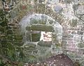
Although the ruins were clearly fortified (four musket firing bays are clearly visible on the seaward side of the ground floor on the main house), the house was not a public maintained fort, and was not known to have engaged in any armed conflicts. It is possible that the ruin was only fortified subsequently as a potential defence and slave insurrections prior to the abolition of slavery.
Cinnamon Bay is a body of water and a beach on St. John island, within Virgin Islands National Park, in the United States Virgin Islands.
Fort Purcell is a ruined fort near Pockwood Pond on the island of Tortola in the British Virgin Islands.
The Copper Mine on Virgin Gorda, British Virgin Islands, is a national park containing the ruins of an abandoned 19th-century copper mine.
Fort George is a colonial fort which was erected on the northeast edge of Road Town, Tortola in the British Virgin Islands above Baugher's Bay. The site is now a ruin.
In common with most Caribbean countries, slavery in the British Virgin Islands forms a major part of the history of the Territory. One commentator has gone so far as to say: "One of the most important aspects of the History of the British Virgin Islands is slavery."
Mount Healthy windmill is a ruined windmill on the north side of Tortola in the British Virgin Islands. It was formerly used during the plantation era of the Territory to crush sugar cane. After the collapse of the sugar economy in the early nineteenth century the windmill fell into disuse and became a ruin. It crushed cane for the sugar mill and rum distillery in nearby Brewer's Bay. There are other ruins like the Boiling House, remnants of the Animal Mill Round, distillery, hospital, storage, shed, and housing. The 18th century windmill belonged to the area's wealthiest planter. Slaves harvested and processed sugar cane into sugar at this extensive sugarcane plantation.
The Cooten Bay ruin is a ruin in Cooten Bay, on the north side of Tortola in the British Virgin Islands. The ruin probably dates from the sugar plantation era, although the fortification of the property with cannon may suggest an earlier date. It was presumed abandoned during the economic collapse of the British Virgin Islands during the mid-19th century, when many plantations were abandoned.
Great Thatch ruin is a ruin on Great Thatch island in the British Virgin Islands.
The Whelk Point Fort was a colonial fort erected on the southeast part of Tortola in the British Virgin Islands. The fort fell into disrepair and ruin, and relatively little of the original structure remains. In 1992 a house was built over the original foundations of the fort, but the remains of the barracks can still be seen on the land behind the house. The ruins are on private property and are not generally accessible to the public.
Portnablagh is a small village in County Donegal in Ulster, the northern province in Ireland. Portnablagh is located on the north-west coast of County Donegal, specifically the west side of Sheephaven Bay. It is on the N56 road.
Cinnamon Bay Plantation is an approximately 300-acre (1.2 km2) property situated on the north central coast of Saint John in the United States Virgin Islands adjacent to Cinnamon Bay. The land, part of Virgin Islands National Park, was added to the United States National Register of Historic Places on July 11, 1978. Archaeological excavations of the land document ceremonial activity of the Taínos, as well as historic remains of plantation ruins.
Reef Bay Sugar Factory Historic District is a historic section of Saint John, United States Virgin Islands located on the south central coast adjacent to Reef Bay. The land is the site of a sugar factory. The property was added to the U.S. National Register of Historic Places on July 23, 1981.
The Dutch Virgin Islands is the collective name for the enclaves that the Dutch West India Company had in the Virgin Islands. The area was ruled by a director, whose seat was not permanent. The main reason for starting a colony here was that it lay strategically between the Dutch colonies in the south and New Netherland. The Dutch West India Company was mainly affected by the competition from Denmark, England and Spain. In 1680 the remaining islands became a British colony.
Larmer Bay ruin is a ruin in Larmer Bay, on the north side of Tortola in the British Virgin Islands. The ruin dates from the sugar plantation era, and was presumed abandoned during the economic collapse of the British Virgin Islands during the mid-19th century.
Leinster Bay is a bay and former sugar cane plantation on the island of Saint John in the United States Virgin Islands. It is uninhabited and part of Virgin Islands National Park. Visitors can park at Annaberg and hike the Leinster Bay trail to access the bay, which is a popular snorkeling spot. Waterlemon Cay is a small cay in Leinster Bay. The ruins of the plantation's estate house can be reached by continuing past the bay and up the Johnny Horn Trail.
Reef Bay is a neighborhood and bay on the island of Saint John in the United States Virgin Islands. Most of this area is part of Virgin Islands National Park. The inhabited portion is along the west side of Reef Bay, near Fish Bay. The Reef Bay Sugar Factory ruins are located in the center of Reef Bay, in an area known as Genti Bay. The nearly 3 mile long Reef Bay Trail is a National Park Service maintained hiking trail that runs through the area from Centerline Road to Genti Bay.
Grove Place is a settlement on the island of Saint Croix in the United States Virgin Islands. It was added to the National Register of Historic Places in 1978.
The Estate Carolina Sugar Plantation near Coral Bay on Saint John, U.S. Virgin Islands is a historic sugar plantation and later rum distillery.
Mosquito Bay plantation was owned by Johan Lorentz Carstens, who was also the owner of the plantations Perlen on Saint Thomas, U.S. Virgin Islands and a smaller plantation on St. Jan.
Slob Historic District, near Christiansted, Virgin Islands, is a historic district which was listed on the National Register of Historic Places in 1987. The listing included nine contributing buildings, three contributing structures, and a contributing site on 9 acres (3.6 ha).
18°26′55″N64°37′02″W / 18.4487°N 64.6172°W