
The British Virgin Islands (BVI), officially the Virgin Islands, is a British Overseas Territory in the Caribbean, to the east of Puerto Rico and the US Virgin Islands and north-west of Anguilla. The islands are geographically part of the Virgin Islands archipelago and are located in the Leeward Islands of the Lesser Antilles and part of the West Indies.
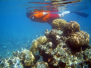
Snorkeling is the practice of swimming face down on or through a body of water while breathing the ambient air through a shaped tube called a snorkel, usually with swimming goggles or a diving mask, and swimfins. In cooler waters, a wetsuit may also be worn. The snorkel may be an independent item or integrated with the mask. The use of this equipment allows the snorkeler to observe the underwater environment for extended periods with relatively little effort, and to breathe while face-down at the surface.
Saint Croix is an island in the Caribbean Sea, and a county and constituent district of the United States Virgin Islands (USVI), an unincorporated territory of the United States.

The British Sub-Aqua Club or BSAC has been recognised since 1954 by UK Sport as the national governing body of recreational diving in the United Kingdom.

Norman Island is an island at the southern tip of the British Virgin Islands archipelago. It is one of a number of islands reputed to be the inspiration for Robert Louis Stevenson's pirate novel Treasure Island.

The Little Sisters is an informal name for a group of some of the smaller islands of the British Virgin Islands, south of Tortola and southwest of Virgin Gorda. These islands are also called the Southern Islands.
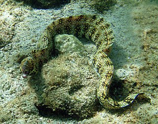
The snowflake moray, also known as the clouded moray among many vernacular names, is a species of marine eel of the family Muraenidae. It has blunt teeth ideal for its diet of crustaceans, a trait it shares with the zebra moray.

A snorkel is a device used for breathing atmospheric air when the wearer's head is face downwards in the water with the mouth and the nose submerged. It may be either a separate unit, or integrated into a swimming or diving mask. The integrated version is only suitable for surface snorkeling, while the separate device may also be used for underwater activities such as spearfishing, freediving, finswimming, underwater hockey, underwater rugby and for surface breathing while wearing scuba equipment. A standard snorkel is a curved tube with a shape usually resembling the letter "L" or "J", fitted with a mouthpiece at the lower end and made from plastic, synthetic elastomers, rubber, or light metal. The snorkel may have a loop or a clip to attach it to the head strap of the diving mask or swimming goggles, or may be tucked between the mask-strap and the head. Some snorkels are fitted with a float valve at the top to prevent flooding if the top opening is immersed, and some are fitted with a water trap and purge valve, intended for draining water from the tube.

Eustatia Island is a 30-acre island of the British Virgin Islands (BVI) in the Caribbean. The word "Eustatia" is a Greek derived word meaning, "good place to stay." The entire island, and a small neighboring island, Saba Rock, are under the same long term lease. The island is regularly featured and photographed for several publications and was listed as one of the top 20 most beautiful islands in the world in the December 2004 issue of Islands magazine.
Congo Cay is an uninhabited island of the United States Virgin Islands, located north of Lovango Cay. It is a snorkeling spot for charter boats from Saint Thomas and Saint John. Congo Cay in the US Virgin Islands is owned by the local government. As pretty much almost all of the smaller islands, islets and cays in the USVI, Congo Cay in the US Virgin Islands is a wild life refuge. It is one of the most beautiful non inhabited cays in the Virgin Islands and a nesting habitat for pelicans.
The marine life found in the Canary Islands is interesting, being a combination of North Atlantic, Mediterranean, and endemic species. In recent years, the increasing popularity of both scuba diving and underwater photography have provided biologists with much new information on the marine life of the islands.

The Indians are an uninhabited small archipelago of islets in the British Virgin Islands in the Caribbean. They are west of the small British Pelican Island and east of the small US Flanagan Island.

The Maldives, officially the Republic of Maldives, is a small archipelagic state in South Asia. It lies in the Indian Ocean southwest of Sri Lanka and India, about 700 kilometres (430 mi) from the Asian continent's mainland. The chain of 26 atolls stretches across the Equator from Ihavandhippolhu Atoll in the north to Addu Atoll in the south. The land area is roughly 298 square kilometres. Malé is the capital.

Molokini is a crescent-shaped, partially submerged volcanic crater which forms a small, uninhabited islet located in ʻAlalākeiki Channel between the islands of Maui and Kahoʻolawe, within Maui County in Hawaiʻi. It is the remains of one of the seven Pleistocene epoch volcanoes that formed the prehistoric Maui Nui island, during the Quaternary Period of the Cenozoic Era.

Carvel Rock is an uninhabited islet of the US Virgin Islands in the Caribbean, less than 2 acres in size. It is visited by boats as a scuba diving site, but its sheer cliffs and lack of a beach mean that landing would be practically impossible.
Coki Beach is on the island of Saint Thomas, United States Virgin Islands, in the Caribbean.
Temple Reef is an artificial reef off the coast of Pondicherry, India. It was constructed of fully recycled materials such as concrete blocks, rocks, trees, palm leaves, and iron bars by the Temple Adventures team starting from October 2013. Temple Reef Foundation currently maintains and monitors the reef.

Wadi El Gemal National Park is a national park in Egypt. It is 7,450 square kilometres (2,880 sq mi) in size, including 4,770 square kilometres (1,840 sq mi) of land and 2,100 square kilometres (810 sq mi) of marine space.

The Frederiksted Pier is the 1,526-foot, deep water, cruise ship pier located in Frederiksted, U.S. Virgin Islands. It is located at the west end of Saint Croix, U.S. Virgin Islands and accommodate two Eagle-class vessels, of a maximum of 142,000 gross tons each with drafts up to 29 feet and two mini-cruise vessels with drafts of 18 feet. Anchorage is also available in the outer harbor for larger ships. The platform of the pier is equipped with a fendering system that is designed for submarines.

Steven Cay is a small scrub-covered and rocky Caribbean island, about 28 feet high and situated 0.5 miles west of Cruz Bay on Saint John in the United States Virgin Islands. It is a popular destination for snorkelers and scuba divers,.


