
Sandy Hook is a barrier spit in Middletown Township, Monmouth County, New Jersey, United States. The barrier spit, approximately 6 miles (9.7 km) in length and varying from 0.1 to 1.0 mile wide, is located at the north end of the Jersey Shore. It encloses the southern entrance of Lower New York Bay south of New York City, protecting it from the open waters of the Atlantic Ocean to the east.

A cay, also spelled caye or key, is a small, low-elevation, sandy island on the surface of a coral reef. Cays occur in tropical environments throughout the Pacific, Atlantic, and Indian oceans, including in the Caribbean and on the Great Barrier Reef and Belize Barrier Reef.

The Abaco Islands lie in the northern Bahamas, about 193 miles east of Miami, Florida. The main islands are Great Abaco and Little Abaco, which is just west of Great Abaco's northern tip. There are several smaller barrier cays, of which the northernmost are Walker's Cay and its sister island Grand Cay. To the south, the next inhabited islands are Spanish Cay and Green Turtle Cay, with its settlement of New Plymouth, Great Guana Cay, private Scotland Cay, Man-O-War Cay, and Elbow Cay, with its settlement of Hope Town. Southernmost are Tilloo Cay and Lubbers Quarters. Also of note off Abaco's western shore is Gorda Cay, now a Disney-owned island and cruise ship stop renamed Castaway Cay. Also in the vicinity is Moore's Island. On the Big Island of Abaco is Marsh Harbour, the Abacos' commercial hub and the Bahamas' third-largest city, plus the resort area of Treasure Cay. Both have airports. A few mainland settlements of significance are Coopers Town and Fox Town in the north and Cherokee and Sandy Point in the south. Administratively, the Abaco Islands constitute seven of the 31 Local Government Districts of the Bahamas: Grand Cay, North Abaco, Green Turtle Cay, Central Abaco, South Abaco, Moore's Island, and Hope Town.

Exuma is a district of The Bahamas, consisting of over 365 islands and cays.

Mayreau is the smallest inhabited island of the Grenadines, with an area of about 0.46 sq. miles and a population of about 271. The population is centered in an unnamed village, located on Station Hill, a hilltop in the south-west of the island. It is an isolated community, accessible only by boat. Electricity was only recently (2002) provided by a central generator located on Saline Bay. There is a single-lane concrete road leading from the wharf on Saline Bay through the village to Saltwhistle Bay. The top of the island is crested with the small elementary school; the telecommunications building; the brick and stone Catholic Church of the Immaculate Conception, christened on May 12, 1930, and a Pentecostal church. From the crest of the hill behind the Catholic Church, there is an overlook of the Tobago Cays, Canouan and Union Island.

The Cayos Arcas is a chain of three tiny sand cays and an accompanying reef system in the Gulf of Mexico, 128 kilometres from the mainland. It is located approximately 130 kilometres from the mainland, west of Campeche. Their aggregate land area is 22.8 hectares. They belong to the municipality of Campeche in the state of Campeche.

Trunk Bay is a body of water and a beach on St. John in the United States Virgin Islands. Trunk Bay is part of the Virgin Islands National Park. Trunk Bay is named for the Leatherback turtle, which is endemic to the USVI and are locally known as trunks. The beach area is divided into two halves, the main Trunk Bay beach and swim area and Burgesman Cove which is located on the west end of Trunk Bay near Jumby Bay. Its amenities include a snack bar, showers and restrooms, a lifeguard, and an underwater trail for snorkeling its coral reef. Trunk Bay has consistently been voted one of the top beaches in the world.

North Caicos is the second-largest island in the Turks and Caicos Islands. To the west, the Caicos Cays link to Providenciales. To the east, it is separated from Middle Caicos by Juniper Hole, a narrow passage that can accommodate only small boats. A 1600-m (1-mile) causeway connects North Caicos to Middle Caicos.
Treasure Cay, is a parcel of land connected to Great Abaco Island in the Bahamas. It has a population of 1,187 as of the 2010 Bahaman census.

Waterhouse Island, part of the Waterhouse Island Group, is a 287-hectare (710-acre) granite island situated in Banks Strait, part of Bass Strait, lying close to the north-eastern coast of Tasmania, Australia.

Green Cay is an uninhabited island of the British Virgin Islands in the Caribbean. It sits between the eastern tip of Little Jost Van Dyke and Tortola. It is 14 acres (6 ha) in area.
Waterlemon Cay is a small cay surrounded by a fringing reef located in Leinster Bay on Saint John, U.S. Virgin Islands. It is named after the water lemon.

Sandy Cay is an uninhabited island of the British Virgin Islands in the Caribbean. It is located between Tortola and Jost Van Dyke. The island was owned by the Laurance Rockefeller Estate. On 1 May 2008, ownership of the island was transferred to the National Parks Trust of the Virgin Islands. In 2002, International NGO, Island Resources Foundation led a project to eradicate invasive black rats from the island.

Lankiam Cay, also known as Panata Island, is the smallest of the naturally occurring Spratly Islands. It has an area of 0.44 hectares, and is located about 7 nautical miles east-northeast of Philippine-occupied Loaita (Kota) Island, just west of the north of Dangerous Ground.
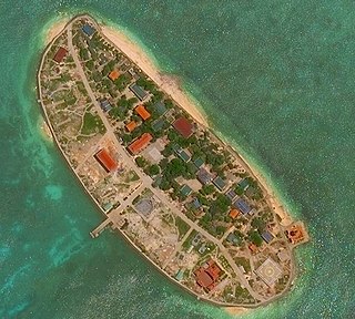
Sand Cay, also known as Bailan Island and Son Ca Island, is a cay on the north edge of the Tizard Bank of the Spratly Islands in the South China Sea. With an area of 7 hectares, it is the ninth largest, and the fourth largest former Vietnamese-administered, of the Spratly Islands. The island has been occupied by Vietnam since 1974,. It is also claimed by China (PRC), the Philippines, Vietnam, and Taiwan (ROC).
Stocking Island is a small, long, narrow island off the port of George Town, Great Exuma Island, The Bahamas. The island features beaches and several resorts.

Sphaerodactylus macrolepis, also known as the big-scaled dwarf gecko or the big-scaled least gecko, is a lizard of the Sphaerodactylus genus. It was first documented in 1859 in the US Virgin Islands, specifically, St. Croix. This diurnal species has since been spotted in other locations such as Puerto Rico with major populations in Culebra.
Dog Island is an uninhabitated small island of 207 ha located approximately 13 km (8.1 mi) to the north-west of Anguilla. It is low and rocky, with three small cays off the west and north coasts. The coastline is characterised by low cliffs alternating with sandy beaches. Large ponds lie inside two of the beaches. Dog Island lies west of the Prickley Pear Cays.


