Great Thatch ruin

Last updated

The ruin on Great Thatch Great Thatch ruin - main pic.jpg
The ruin on Great Thatch

Great Thatch ruin is a ruin on Great Thatch island in the British Virgin Islands.

The ruin probably dates from the sugar plantation era, but may be earlier. It was presumed abandoned during the economic collapse of the British Virgin Islands during the mid-19th century, when many plantations were abandoned. The ruin covers a significant estate, [1] and is an indicator of some wealth.

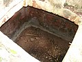
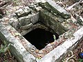
It is not clear when the ruin was finally fully abandoned, although bottles found on the site from the Portobello bottle company in Edinburgh, Scotland, suggest that it may have been as late as 1907.[ citation needed ] The cistern on the site does not exhibit the same level of deterioration as similar parts of ruins in the Territory[ citation needed ] which are known to have been abandoned during the 1850s.

Images

Footnotes

  1. Gerald (8 April 2010). "THE RUINS OF GREAT THATCH". See St John. Retrieved 13 December 2020.

Related Research Articles

British Virgin Islands British Overseas Territory in the Caribbean

The British Virgin Islands, officially the Virgin Islands, are a British Overseas Territory in the Caribbean, to the east of Puerto Rico and the U.S. Virgin Islands and north-west of Anguilla. The islands are geographically part of the Virgin Islands archipelago and are located in the Leeward Islands of the Lesser Antilles and part of the West Indies.

Virgin Islands Island group of the Caribbean Leeward Islands

The Virgin Islands are an archipelago in the Caribbean Sea. They are geologically and biogeographically the easternmost part of the Greater Antilles, the northern islands belonging to the Puerto Rico Trench and St. Croix being a displaced part of the same geologic structure. Politically, the British Virgin Islands have been governed as the western island group of the Leeward Islands, which are the northern part of the Lesser Antilles, and form the border between the Caribbean Sea and the Atlantic Ocean. The archipelago is separated from the true Lesser Antilles by the Anegada Passage and from the main island of Puerto Rico by the Virgin Passage.

Tobago autonomous island in the Republic of Trinidad and Tobago

Tobago is an island within the Republic of Trinidad and Tobago. It is located 35 kilometres (22 mi) northeast of the mainland of Trinidad and southeast of Grenada, about 160 kilometres (99 mi) off the coast of northeast Venezuela. According to the earliest English-language source cited in the Oxford English Dictionary, Tobago bore a name that has become the English word tobacco. The official bird of Tobago is the cocrico.

Wupatki National Monument Protected area in Coconino County, Arizona

The Wupatki National Monument is a United States National Monument located in north-central Arizona, near Flagstaff. Rich in Native American archaeological sites, the monument is administered by the National Park Service in close conjunction with the nearby Sunset Crater Volcano National Monument. Wupatki was listed on the National Register of Historic Places on October 15, 1966. The listing included three contributing buildings and 29 contributing structures on 35,253.2 acres (14,266.5 ha).

Saint John, U.S. Virgin Islands One of the main islands of the United States Virgin Islands

Saint John is one of the Virgin Islands in the Caribbean Sea and a constituent district of the United States Virgin Islands (USVI), an unincorporated territory of the United States.

Water Island, U.S. Virgin Islands

Water Island is an island territory currently belonging to the American Virgin Islands, an American territory located in the Caribbean Sea. The rest of the U.S. Virgin Islands were acquired by the Americans in 1917 from Denmark, however Water Island was excluded, thus the Danish East Asiatic Company, and by proxy the Danish kingdom, continued to own Water Island until several decades later. Water Island was bought by the American government in 1944, and in 1996 it was transferred to the U.S. Virgin Islands. The island is of volcanic origin and lies to the south of Saint Thomas in the Charlotte Amalie harbor. Ferry service runs regularly from Crown Bay, Saint Thomas to Phillips Landing, Water Island; the ferry ride is about 10 minutes.

Derrygonnelly Human settlement in Northern Ireland

Derrygonnelly is a small village and townland in County Fermanagh, Northern Ireland. Near Lower Lough Erne, the village was home to 680 people and dates to the Plantation era. It is situated within Fermanagh and Omagh district.

Fort Purcell is a ruined fort near Pockwood Pond on the island of Tortola in the British Virgin Islands.

Copper Mine, Virgin Gorda

The Copper Mine on Virgin Gorda, British Virgin Islands, is a national park containing the ruins of an abandoned 19th-century copper mine.

Piracy in the British Virgin Islands

Piracy in the British Virgin Islands was prevalent during the so-called "Golden Age of Piracy", mainly during the age of 1690-1730. Privateering was also widely practised in the jurisdiction throughout frequent colonial wars, not least by emancipated slaves who, with in preference to back-breaking labour in the fields for pitiful wages, took enormous risks to capture fortunes on the seas with the sanction of the Crown. In 1808, Patrick Colquhoun, a prize agent for the Territory spoke of "the most daring outrages which are frequently committed by people of colour."

Slavery in the British Virgin Islands

In common with most Caribbean countries, slavery in the British Virgin Islands forms a major part of the history of the Territory. One commentator has gone so far as to say: "One of the most important aspects of the History of the British Virgin Islands is slavery."

Hans Lollik Island

The Hans Lollik Islands are two islands in the US Virgin Islands. Great Hans Lollik Island ("GHL") is found approximately 8,000 feet beyond the central northshore of St. Thomas, US Virgin Islands, separated from St. Thomas by the Leeward Passage. Little Hans Lollik and Pelican Cay lie to the north of Hans Lollik on the same shelf. The major part of the benthic zone around Hans Lollik is rocky and supports a dense diverse coral habitat.

Babingley Human settlement in England

Babingley is a hamlet and abandoned village in Norfolk, England, about 1 mile (1.6 km) northwest of Castle Rising and 5 12 miles (9 km) north-north-east of King's Lynn.

Great Thatch

Great Thatch is an uninhabited island of the British Virgin Islands in the Caribbean. It is one of the westernmost islands in the Territory. It is believed to take its name from the famous pirate, Edward Teach, although there is little evidence Blackbeard ever sailed in the Virgin Islands.

Mount Healthy windmill

Mount Healthy windmill is a ruined windmill on the north side of Tortola in the British Virgin Islands. It was formerly used during the plantation era of the Territory to crush sugar cane. After the collapse of the sugar economy in the early nineteenth century the windmill fell into disuse and became a ruin. It crushed cane for the sugar mill and rum distillery in nearby Brewer's Bay. There are other ruins like the Boiling House, remnants of the Animal Mill Round, distillery, hospital, storage, shed, and housing. The 18th century windmill belonged to the area's wealthiest planter. Slaves harvested and processed sugar cane into sugar at this extensive sugarcane plantation.

Cooper Bay ruin

Cooper Bay ruin is a ruin in Cooper Bay, on the north side of Tortola in the British Virgin Islands. The ruin dates from the sugar plantation era, and was presumed abandoned during the economic collapse of the British Virgin Islands during the mid-19th century.

Cooten Bay ruin

The Cooten Bay ruin is a ruin in Cooten Bay, on the north side of Tortola in the British Virgin Islands. The ruin probably dates from the sugar plantation era, although the fortification of the property with cannon may suggest an earlier date. It was presumed abandoned during the economic collapse of the British Virgin Islands during the mid-19th century, when many plantations were abandoned.

Catherineberg Sugar Mill Ruins United States historic place

Catherineberg Sugar Mill Ruins is an historic site located in the Virgin Islands National Park, east of Cruz Bay on Saint John, U.S. Virgin Islands. The ruins are an example of an 18th-century sugar and rum factory.

Larmer Bay ruin

Larmer Bay ruin is a ruin in Larmer Bay, on the north side of Tortola in the British Virgin Islands. The ruin dates from the sugar plantation era, and was presumed abandoned during the economic collapse of the British Virgin Islands during the mid-19th century.

Ruins photography Sub-genre of photography

Ruins photography, sometimes called ruin porn, is a recent movement in photography that takes the decline of the built environment as its subject. While "ruins" may be broadly defined as the remnants of human achievement, "ruins photography" refers specifically to the capture of urban decay in the post-industrial areas of the world. Ruins photography catalogues the abandonment and decline of cities most of all, and has sparked conversations about the role of art in various urban renewal, restoration, and conservation projects in cities throughout the globe.