
The British Virgin Islands (BVI), officially the Virgin Islands, are a British Overseas Territory in the Caribbean, to the east of Puerto Rico and the US Virgin Islands and north-west of Anguilla. The islands are geographically part of the Virgin Islands archipelago and are located in the Leeward Islands of the Lesser Antilles and part of the West Indies.
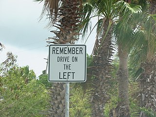
The United States Virgin Islands (USVI) is the only place under United States jurisdiction where the rule of the road is to drive on the left. However, virtually all passenger vehicles are left hand drive due to imports of U.S. vehicles.

The history of the British Virgin Islands is usually, for convenience, broken up into five separate periods:
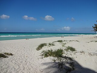
Varadero, also referred to as Playa Azul, is a resort town in the province of Matanzas, Cuba, and one of the largest resort areas in the Caribbean. Varadero Beach is rated one of the world's best beaches in TripAdvisor's Traveler's Choice Awards since 2019, ranking at number 9 as of January 2024. Common activities include fishing and excursions to Matanzas, Cárdenas, and the Península de Zapata.

The Abaco Islands lie in the north of The Bahamas, about 193 miles east of Miami, Florida, US. The main islands are Great Abaco and Little Abaco, which is just west of Great Abaco's northern tip. There are several smaller barrier cays, of which the northernmost are Walker's Cay and its sister island Grand Cay. To the south, the next inhabited islands are Spanish Cay and Green Turtle Cay, with its settlement of New Plymouth, Great Guana Cay, private Scotland Cay, Man-O-War Cay and Elbow Cay, with its settlement of Hope Town. Southernmost are Tilloo Cay and Lubbers Quarters. Also of note off Abaco's western shore is Gorda Cay, now a Disney-owned island and cruise ship stop renamed Castaway Cay. Also in the vicinity is Moore's Island. On the Big Island of Abaco is Marsh Harbour, the Abacos' commercial hub and The Bahamas' third-largest city, plus the resort area of Treasure Cay. Both have airports. Mainland settlements include Coopers Town and Fox Town in the north and Cherokee and Sandy Point in the south. Administratively, the Abaco Islands constitute seven of the 31 Local Government Districts of The Bahamas: Grand Cay, North Abaco, Green Turtle Cay, Central Abaco, South Abaco, Moore's Island and Hope Town.

Road Town, located on Tortola, is the capital and largest town of the British Virgin Islands. It is situated on the horseshoe-shaped Road Harbour in the centre of the island's south coast. The population was about 15,000 in 2018.
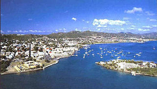
Christiansted is the largest town on Saint Croix, one of the main islands composing the United States Virgin Islands, a territory of the United States of America. The town is named after King Christian VI of Denmark.
Tortola is the largest and most populated island of the British Virgin Islands, a group of islands that form part of the archipelago of the Virgin Islands. It has a surface area of 55.7 square kilometres with a total population of 23,908, with 9,400 residents in Road Town. Mount Sage is its highest point at 530 metres above sea level.

Necker Island is a 30-hectare (74-acre) island in the British Virgin Islands just north of Virgin Gorda. The island is entirely owned by Sir Richard Branson, chairman of the Virgin Group, and is part of the Virgin Limited Edition portfolio of luxury properties. The whole island operates as a resort and can accommodate up to 40 guests, with additional room for six children.

Cayo Coco (Cays) or is an island on the north coast of central Cuba, known for its all-inclusive resorts. It lies within the Ciego de Ávila Province and is part of a chain of islands called Jardines del Rey. The cay is administered by the Morón municipality, has a surface area of 370 km2, and is named after the white ibis, locally called coco (coconut) birds. The island is known for its long beaches and many resort hotels.

Salt Cay is the second largest of the Turks Islands, one of the two island groups forming of the British territory of the Turks and Caicos Islands in the Caribbean. Its area is 6.74 square kilometres. The size of the district, which also includes some unpopulated islands like Cotton Cay nearby, is 9.1 square kilometres. The population is 108, all in the district capital Balfour Town, established in 1673, on the west coast.

The Collectivity of Saint Martin, commonly known as simply Saint Martin, is an overseas collectivity of France in the West Indies in the Caribbean, on the northern half of the island of Saint Martin, as well as some smaller adjacent islands. Saint Martin is separated from the island of Anguilla by the Anguilla Channel. Its capital is Marigot.

Robb White III was an American writer of screenplays, television scripts, and adventure novels. Most of the latter had a maritime setting, often the Pacific Navy during World War II. White was best known for juvenile fiction, though he has proven popular with adults as well. Nearly all his books are out of print; nevertheless, White has a devoted following among baby boomers, many of whom were introduced to him through inexpensive paperbacks available in American schools in the mid-20th century.
Bellamy Cay is an island in the British Virgin Islands, located entirely within Trellis Bay on Beef Island. Formerly called Blanco Islet, this island is named after its most famous resident, "Black Sam" Bellamy, the "prince of pirates".

Eustatia Island is a 30-acre island of the British Virgin Islands (BVI) in the Caribbean. The word "Eustatia" is a Greek derived word meaning, "good place to stay." The entire island, and a small neighboring island, Saba Rock, are under the same long term lease. The island is regularly featured and photographed for several publications and was listed as one of the top 20 most beautiful islands in the world in the December 2004 issue of Islands magazine.
The Cat Cays are two islands in the Bahamas, North Cat Cay and South Cat Cay, approximately 10 miles (16 km) south of Bimini. North Cat Cay is a privately owned island and is run as a private members club by the Cat Cay Yacht Club. South Cat Cay is currently under development.
Eugene K. Tonkonogy was an entrepreneur, lawyer, and owner of the island Marina Cay.

Hurricane Irma was an extremely powerful and devastating tropical cyclone that was the first Category 5 hurricane to strike the Leeward Islands on record, followed by Maria two weeks later. At the time, it was considered the most powerful hurricane on record in the open Atlantic region, outside of the Caribbean Sea and Gulf of Mexico, until it was surpassed by Hurricane Dorian two years later. It was also the third-strongest Atlantic hurricane at landfall ever recorded, just behind the 1935 Labor Day Hurricane and Dorian. The ninth named storm, fourth hurricane, second major hurricane, and first Category 5 hurricane of the extremely active 2017 Atlantic hurricane season, Irma caused widespread and catastrophic damage throughout its long lifetime, particularly in the northeastern Caribbean and the Florida Keys. It was also the most intense hurricane to strike the continental United States since Katrina in 2005, the first major hurricane to make landfall in Florida since Wilma in the same year, and the first Category 4 hurricane to strike the state since Charley in 2004. The word Irmageddon was coined soon after the hurricane to describe the damage caused by the hurricane.

The Virgin Islands are an archipelago in the Caribbean Sea. The islands fall into three different political jurisdictions:
The effects of Hurricane Irma in the British Virgin Islands were significant in terms of both human and socio-economic impact on the Territory. Hurricane Irma struck the British Virgin Islands as a Category 5 hurricane during the daylight hours of Wednesday, 6 September 2017. It caused widespread destruction, and killed a total of four people. The eye of the hurricane traveled over the three major islands in the group: Virgin Gorda, Tortola and Jost Van Dyke.


