The original structure is believed by some to have been built at an unascertained date by the original Dutch settlers of the islands to protect slave pens that were built in Port Purcell below. It is likely that the initial structure was built in response to a massacre of the inhabitants of the original settlement in Baugher's Bay in 1625.
However, the main fortification was built (or rebuilt) by the British in the late 18th century around the outbreak of the American War of Independence as part of the general upgrade of the fortifications of Road Town.
Fort George formed part of a formidable defensive network of forts around Road Town at this time, including the eponymous Road Town Fort (under what is now the site of the Boungainvillea clinic), Fort Burt above Road Reef on the south west side of the harbour, and Fort Charlotte set high above on Harrigan's Hill.
Fort George never actually engaged in combat after restoration by the British. The combination of the formidable martial defences of Road Town, and relatively small strategic and economic importance of Tortola persuaded both foreign colonial powers and privateers and pirates alike to focus on other targets within the region.
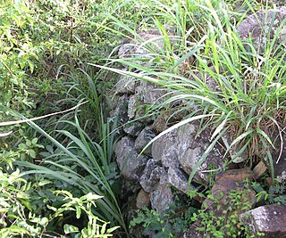
Today the remains of the fort are barely recognisable. Despite being featured in the British Virgin Island government's promotional website the remains of the Fort are on private land, to which there is no public access. The property has a house on it, which is rented, and access to the site depends upon the goodwill of the incumbent tenants. As of 2007[update] the remains are predominantly used as storage.
The history of the British Virgin Islands is usually, for convenience, broken up into five separate periods:
Road Town, located on Tortola, is the capital and largest town of the British Virgin Islands. It is situated on the horseshoe-shaped Road Harbour in the centre of the island's south coast. The population was about 15,000 in 2018.
Tortola is the largest and most populated island of the British Virgin Islands, a group of islands that form part of the archipelago of the Virgin Islands. It has a surface area of 55.7 square kilometres with a total population of 23,908, with 9,400 residents in Road Town. Mount Sage is its highest point at 530 metres above sea level.
Cruz Bay, U.S. Virgin Islands is the main town on the island of Saint John in the United States Virgin Islands. According to the 2000 census, Cruz Bay had a population of 2,743.
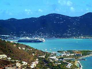
Road Harbour, located in Road Town, Tortola, is the commercial seaport of the British Virgin Islands. There are a number of smaller marinas around the harbour, such as the Road Reef Marina and the Fort Burt Marina, an overnight small boat anchorage, customs and immigration offices. Inter island ferries stop at the ferry dock on the NW edge of Road Harbour next to Customs. Road Harbour is deep and large enough to handle many of the cruise ships that make Tortola a port of call.
The Queen Elizabeth II Bridge, sometimes called the Beef Island Bridge, is a bridge, 70 meters (230 ft) long, that links Beef Island with Tortola in the British Virgin Islands. The original bridge was opened in 1966, and was replaced by a new bridge in 2003.
St. Phillip's Anglican Church, also known as the African Church, in the Kingstown area of Tortola in British Virgin Islands, was built in 1840 by a community of Africans who had been liberated from illegal slave ships.
Fort Purcell is a ruined fort near Pockwood Pond on the island of Tortola in the British Virgin Islands.
Joost van Dyk was a Dutch privateer who was one of the earliest European settlers in the British Virgin Islands in the seventeenth century, and established the first permanent settlements within the Territory. The islands of Jost Van Dyke and its smaller neighbor Little Jost Van Dyke, as well as Little Dix Bay on Virgin Gorda island, are named after him.
Fort Charlotte is a fort built on Harrigan's Hill, Tortola, British Virgin Islands. The fort was named after Queen Charlotte.
Fort Burt is a colonial fort that was erected on the southwest edge of Road Town, Tortola in the British Virgin Islands above Road Reef Marina. The site is now a hotel and restaurant of the same name, and relatively little of the original structure remains. However, one of the original cannons has survived and stands on the veranda of the hotel, vigilantly looking over the harbour.
Fort Recovery is a fort on the West End of Tortola in the British Virgin Islands. In historical records, the fort is often referred to as Tower Fort, and the area around the fort is still referred to as "Towers" today. A hotel is now built around the Tower.
Road Town Fort is a colonial fort which was erected on Russell Hill in Road Town, Tortola in the British Virgin Islands above the town's main wharf. In historical records it is sometimes referred to as Fort Road Town. The fort subsequently fell into ruin, and in the 1960s the Bougainvillea clinic was built on top of the old structure. The strong room of the original fort, which was once the Territory's treasury, still survives today, and is now used as a storeroom by the clinic.
Wickams Cay and Little Wickam's Cay were former islands of the British Virgin Islands in the Caribbean. They were both located in Road Harbour, but due to reclamation of land projects in Tortola, Wickhams Cay now makes up part of Road Town, the capital of the British Virgin Islands. The areas are known as Wickhams Cay and Wickhams Cay II. Also included in the same reclamation projects were former islands known as Bird Cay and Dead Horse Cay.
Several of the islands strung across the South entrance of Castle Harbour, Bermuda were fortified in the early days of the territory, hence the harbour's name. When official settlement of the archipelago by England began in 1612 the first permanent town, St. George's was placed on the North side of St. George's Harbour. St. George's Harbour could be accessed directly by channels from the East. Those channels, however, were shallow, suitable, originally, only for small ships. As a consequence, and despite any major settlement on its shores, Castle Harbour was an important anchorage in the early years of the colony, with its main entrance, Castle Roads being an important route in from the open Atlantic for shipping. It was also a weak point, as it was remote from the defences of St. George's Harbour, and difficult to reach. It was quickly fortified and garrisoned by a standing militia.
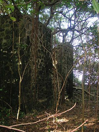
Cooper Bay ruin is a ruin in Cooper Bay, on the north side of Tortola in the British Virgin Islands. The ruin dates from the sugar plantation era, and was presumed abandoned during the economic collapse of the British Virgin Islands during the mid-19th century.
The Cooten Bay ruin is a ruin in Cooten Bay, on the north side of Tortola in the British Virgin Islands. The ruin probably dates from the sugar plantation era, although the fortification of the property with cannon may suggest an earlier date. It is presumed that it was abandoned during the economic collapse of the British Virgin Islands during the mid-19th century, when many plantations were abandoned.
The Whelk Point Fort was a colonial fort erected on the southeast part of Tortola in the British Virgin Islands. The fort fell into disrepair and ruin, and relatively little of the original structure remains. In 1992 a house was built over the original foundations of the fort, but the remains of the barracks can still be seen on the land behind the house. The ruins are on private property and are not generally accessible to the public.
The Dutch Virgin Islands is the collective name for the enclaves that the Dutch West India Company had in the Virgin Islands. The area was ruled by a director, whose seat was not permanent. The main reason for starting a colony here was that it lay strategically between the Dutch colonies in the south and New Netherland. The Dutch West India Company was mainly affected by the competition from Denmark, England and Spain. In 1680 the remaining islands became a British colony.
Larmer Bay ruin is a ruin in Larmer Bay, on the north side of Tortola in the British Virgin Islands. The ruin dates from the sugar plantation era, and was presumed abandoned during the economic collapse of the British Virgin Islands during the mid-19th century.
This page is based on this Wikipedia article Text is available under the CC BY-SA 4.0 license; additional terms may apply. Images, videos and audio are available under their respective licenses.