
The Hayle Estuary and Carrack Gladden SSSI is a Site of Special Scientific Interest, noted for its biological interest, in west Cornwall, England, UK. It consists of three distinct parts, each of which is covered in a separate article: the Hayle Estuary, the sand-dune system of Porth Kidney Sands and the coastal headland at Carrack Gladden.

Hayle is a port town and civil parish in west Cornwall, United Kingdom. It is situated at the mouth of the Hayle River and is approximately seven miles (11 km) northeast of Penzance.

Angarrack is a village in west Cornwall, England, UK. It is in the parish of Gwinear-Gwithian a mile to the east of Hayle. Immediately south of the village Angarrack viaduct carries the Cornish mainline railway over the Angarrack River. The name comes from An Garrek which means "The Rock" in the Cornish language. According to the Ordnance Survey the spelling is Angarrack but on signs near the village, it is variously spelled Angarrack, Angharrack, or Angarrick.

Phillack is a village in west Cornwall, England, United Kingdom. It is about one mile (1.6 km) northeast of Hayle and half-a-mile (0.8 km) inland from St Ives Bay on Cornwall's Atlantic ocean coast. The village is separated from the sea by a range of high sand dunes known as The Towans.

Connor Downs is a village in west Cornwall, England, United Kingdom, in the civil parish of Gwinear-Gwithian. It is situated approximately two miles (3 km) east of Hayle and about two miles south-southeast of Gwithian churchtown. The name "Connor" was originally the name of Connerton, the medieval manor of the parish of Gwithian.
The West Cornwall Railway was a railway company in Cornwall, Great Britain, formed in 1846 to construct a railway between Penzance and Truro. It purchased the existing Hayle Railway, and improved its main line, and built new sections between Penzance and Hayle, and between Redruth and Truro, and opened throughout in 1852.

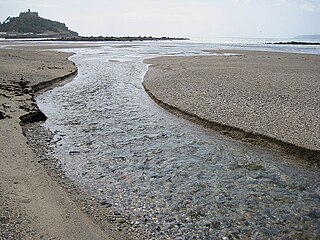
The River Hayle is a small river in West Cornwall, England, United Kingdom which issues into St Ives Bay at Hayle on Cornwall's Atlantic coast.

Towan is found in many placenames in Cornwall. However, The Towans usually refers to the three-mile (5 km) stretch of coastal dunes which extends north-east from the estuary of the River Hayle to Gwithian beach with a midpoint near Upton.
Joppa is a farmstead settlement in Cornwall, England, United Kingdom. It is situated approximately one mile (1.6 km) southeast of Hayle and is in Hayle civil parish.
There are seventeen disused railway stations on the Cornish Main Line between Plymouth in Devon and Penzance in Cornwall, England. The remains of nine of these can be seen from passing trains. While a number of these were closed following the so-called "Beeching Axe" in the 1960s, many of them had been closed much earlier, the traffic for which they had been built failing to materialise.

Fraddam is a village in west Cornwall, England, United Kingdom. It is two miles (3 km) southeast of Hayle. It is in the civil parish of Gwinear-Gwithian
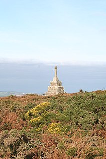
Tregonning Hill is the westerly of two granite hills overlooking Mount's Bay in west Cornwall, United Kingdom, the other being Godolphin Hill. They are approximately 6 kilometres (3.7 mi) west of the town of Helston. The Plymouth chemist William Cookworthy mixed china stone with kaolin, mined from the hill to make Plymouth porcelain; which was the first time porcelain was made in Europe. Part of the hill is designated as a Site of Special Scientific Interest (SSSI) and at the date of notification (1994) was the only known site of western rustwort in Great Britain.
The Red River which discharges into the sea to the west of Marazion is one of two watercourses in Cornwall in southwest England, UK, which share this name.
Halamanning is a hamlet in west Cornwall, England, situated approximately 5.5 miles (8.9 km) east of Penzance and 4 miles (6.4 km) south of Hayle. Halamanning is in the parish of St Hilary and is in the Cornwall and West Devon Mining Landscape, which was designated as a World Heritage Site in 2006.

Nancegollan is a village in the civil parish of Crowan in west Cornwall, England. Nancegollan is on the B3303 road and south-east of Leedstown.
Perran Downs is a hamlet near Perranuthnoe, Goldsithney and St Hilary in Cornwall, England. It is close by to the 13th-century St Hilary Church

Wheal Alfred is the site of a former copper and lead mine and a designated Site of Special Scientific Interest (SSSI) in west Cornwall, England, UK. The mine is located 1 mile (1.6 km) east of the town of Hayle and is also a Geological Conservation Review site. The mine is famous to geologists for its important mineral specimens such as mimetite and pyromorphite.
Loggans Moor is a nature reserve and Site of Special Scientific Interest, noted for its biological characteristics, in west Cornwall, England, UK. It is located 1 mile north-east of the town of Hayle, off the A30 road.
The Cornish Copper Company (CCCo) was originally a copper smelting business founded in Camborne, Cornwall in 1756. However it soon moved to Hayle and by 1758 had constructed its copper smelting works there. By 1769 the company had built the grade II listed Copperhouse Dock.
Hayle North is an electoral division of Cornwall in the United Kingdom and returns one member to sit on Cornwall Council. The current Councillor is John Pollard, an Independent.

